Ohio Revolutionary Memorial Commission Historical Markers
In 1930 the Ohio Revolutionary Memorial Commission designated the location of a number of Revolutionary War and War of 1812 markers along the roadways that existed from near Toledo to Cincinnati as parts of the Ohio Revolutionary Memorial Trail network.
Ohio
Revolutionary
Memorial
Trail
$50 Fine
or
10 days
imprison-
ment or
both for
defacing
this
marker
Ohio State
General Code
Section 12489 — — Map (db m137356) HM
Built by General St. Clair in 1791, on his campaign against the Indians.
It was enlarged in 1792 and used by General Wayne in 1793, on his march to Fallen Timbers. — — Map (db m30661) HM
1755 - Simon Kenton - 1836
»»««
In Oakland Cemetery, one
mile east,is the grave and
monument of Simon Kenton,
pioneer, soldier, Indian scout.
Also, "The Indian Hunter,"
by J.Q.A.Ward, noted sculptor
and native of . . . — — Map (db m44106) HM
Near here, at the forks
of the Mad River, in 1799
Simon Kenton and other
Kentuckians erected the
first American Stockade
in the Mad River Valley. — — Map (db m137376) HM
Within this park and immediate vicinity, former site of the Shawnee Indian Village of Piqua. The Shawnees and their British Allies were defeated by General George Rogers Clark with his army of Kentucky Frontiersmen. This battle greatly advanced the . . . — — Map (db m35295) HM
Site of
Fort Jefferson
The most advanced post
established by General St. Clair
on his campaign
against the Northwestern
Indian Tribes in 1791. — — Map (db m138773) HM
Site of
Fort Greene-Ville
»»««
The largest pioneer fort
in Ohio, built in 1793, by
General Anthony Wayne.
Here, August 5, 1795, the
Treaty was signed by which
much of present Ohio was
opened to White . . . — — Map (db m19878) HM
Abatis and Camp
»»««
General Wayne’s Army in
1794 and General Winchester’s
Army in 1812 encamped on
this spot.
Here also was the western
end of Gen. Winchester’s Abatis. — — Map (db m136580) HM
Built by General Wm. H. Harrison in Oct. 1812 and named for General Winchester.
For a time it was the only defensive work against the British and Indians in Northwestern Ohio. — — Map (db m18717) HM
Pontiac Birthplace
»»««
Here, in 1712, was born the
Great Indian chief who in-
cited Pontiac’s Conspiracy.
He federated the tribes and
with the aid of the French
threatened British suprem-
acy. Killed in Illinois . . . — — Map (db m28350) HM
Here, between the site of the old Shawnee Council House and the hill to the south, Simon Kenton, in 1778, successfully ran an Indian Gantlet, 158 rods - almost one half mile - long. — — Map (db m14071) HM
The famous Shawnee Village destroyed four times by pioneer forces. It remained Ohio's leading Indian Town until 1807. On the rise to the west stood the bark Council House. — — Map (db m241945) HM
7/8 mile west – site of
Fort Necessity
Erected in 1812 by Hull’s
army on its march north-
ward from Fort McArthur,
when incessant rains and
mud made further advance
impossible. — — Map (db m136824) HM
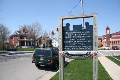
Girty's Island
»»««
Named for George Girty,
renegade brother of Simon Girty.
This was his hiding place
between various treach-
erous expeditions. — — Map (db m136576) HM
Here was fought the first of the major engagements of Logan’s 1786 campaign, in which eight Shawnee towns were destroyed and Chief Moluntha killed. Kenton here ran the gantlet in 1778. — — Map (db m136689) HM
[South side of marker]:
Zanesfield
»»««
Once a Wyandot village and
home of Chief Tarhe, whose
daughter, Myeerah, Isaac Zane
married here about 1776, and thus
established the home of the first
white man . . . — — Map (db m19801) HM
Ohio's
Revolutionary
Memorial
Trail
Text on North Side :
Hull-Winchester Marches
1812 • Marches • 1813
- - - - -
5
Miles to
Hull's
Crossing
Text on South Side : . . . — — Map (db m93522) HM
Ohio's
Revolutionary
Memorial
Trail
Text on North Side :
Hull-Winchester Marches
1812 • Marches • 1813
- - - - -
Michigan
—
Ohio
State Line
Text on South Side : . . . — — Map (db m93602) HM
Site of
Fort Adams
One-fourth mile east.
Built by General Wayne
In August 1794.
A deserter from this fort
warned the Indians of
the American approach. — — Map (db m136595) HM
Here, where the Shawnees were defeated by Clark's 1782 expedition, Dayton was founded, in 1796. Hull's army and other War of 1812 troops were mobilized at this point. — — Map (db m36365) HM
Charloe
»»««
From this point, known as
the “Upper Delaware Town,”
Wayne destroyed the Indians'
abundant crops, which
skirted the Auglaize all
the way to Fort Defiance. — — Map (db m136582) HM
1000 feet east – site of
Fort Brown
Erected in the War of
1812 by a contingent
of Harrison’s army and
commanded by Colonel Brown. — — Map (db m136590) HM
Fort St. Clair
One mile west
Erected in 1791-92, by order
of General James Wilkinson.
Here, on November 6th, 1792,
Major John Adair's Kentucky
Volunteers were attacked by
Little Turtle. — — Map (db m138808) HM
3 miles east – site of
Fort Jennings
Built by Colonel William Jennings
in 1812, as one of the
posts along General Harrison’s
march to the confluence of
the Auglaize and the Maumee. — — Map (db m136591) HM
Two blocks south - site of
Fort Stephenson
Here, in 1813, Major Croghan
with only 160 men and the
cannon, "Old Betsy," heroically
defended the fort against
over 1300 British and Indians.
— — Map (db m221621) HM
Indian Gantlet and Race Course
»»««
From the present State Street
to the railroad bridge was
a famous Indian race track
and gantlet run by captives.
James Whittaker ran it so
well that he was adopted and
given . . . — — Map (db m31692) HM
Site of camps during the
Pontiac Conspiracy
Here Bradstreet's British
expedition camped in 1764.
Also the farthest point
west reached by colonial
forces under command of
Israel Putnam.
— — Map (db m135756) HM
Ohio
Revolutionary
Memorial
Trail
Text on South Side :
Harrison • Shelby
Marches • 1813
- - - - -
12
Miles to
Brady's
Island
Text on North Side :
Harrison • Shelby
Marches . . . — — Map (db m20577) HM
Pioneer Portage
Here, at the headwaters
of the Miami, St. Mary’s and
Auglaize Rivers, was the only
land travel necessary in
early days between the
Lakes and the Ohio River. — — Map (db m136611) HM
Through the forest to the
east may still be seen the
original trail of Hull’s army
in June 1812, enroute to
Detroit. Some of the corduroy
timbers are still buried
along the route. — — Map (db m137357) HM
Ohio's
Revolutionary
Memorial
Trail
Text on West Side :
Harrison's
March • 1813
- - - - -
25
Miles to
Whittaker's
Reserve
Text on East Side :
Harrison's
March • 1813
- - . . . — — Map (db m93495) HM
Founded by Presbyterians in 1822, and, after several changes of administration, abandoned in 1834.
These missions were important factors in the winning of the west. — — Map (db m228820) HM
Ohio's
Revolutionary
Memorial
Trail
Text on West Side :
Harrison's
March • 1813
- - - - -
28
Miles to
Brady's
Island
Text on East Side :
Harrison's
March • 1813
- - - - . . . — — Map (db m93477) HM
Ohio's
Revolutionary
Memorial
Trail
Text on South Side :
Harrison-Hull-Tupper
1812 • Marches • 1813
- - - - -
6
Miles to
Dudley's
Massacre
Text on North Side : . . . — — Map (db m93456) HM
Ohio's
Revolutionary
Memorial
Trail
Text on South Side :
Harrison-Hull-Tupper
1812 • Marches • 1813
- - - - -
½
Mile to
Fort
Meigs
<————
Text on North . . . — — Map (db m93521) HM
Ohio's
Revolutionary
Memorial
Trail
Text on East Side :
Harrison's March - 1813
- - - - -
½
Mile to
Fort
Meigs
Text on West Side :
Harrison's March - 1813
- - - - - . . . — — Map (db m76976) HM
Burning of Crawford
»»««
One-half mile northeast,
June 11, 1782, the Indians
burned Colonel William Crawford
at the stake, in revenge for
massacre of the Christian
Moravian Indians by William-
son's earlier . . . — — Map (db m20362) HM
Ohio's
Revolutionary
Memorial
Trail
Text on South Side :
Harrison's March - 1813
- - - - -
2
Mile to
Crawford's
Burning
Text on North Side :
Harrison's March - 1813
- - - - . . . — — Map (db m93691) HM
Ohio's
Revolutionary
Memorial
Trail
Text on North Side :
Harrison's March - 1813
- - - - -
24
Miles to
Fort
Morrow
Text on South Side :
Harrison's March - 1813
- - - - - . . . — — Map (db m94531) HM