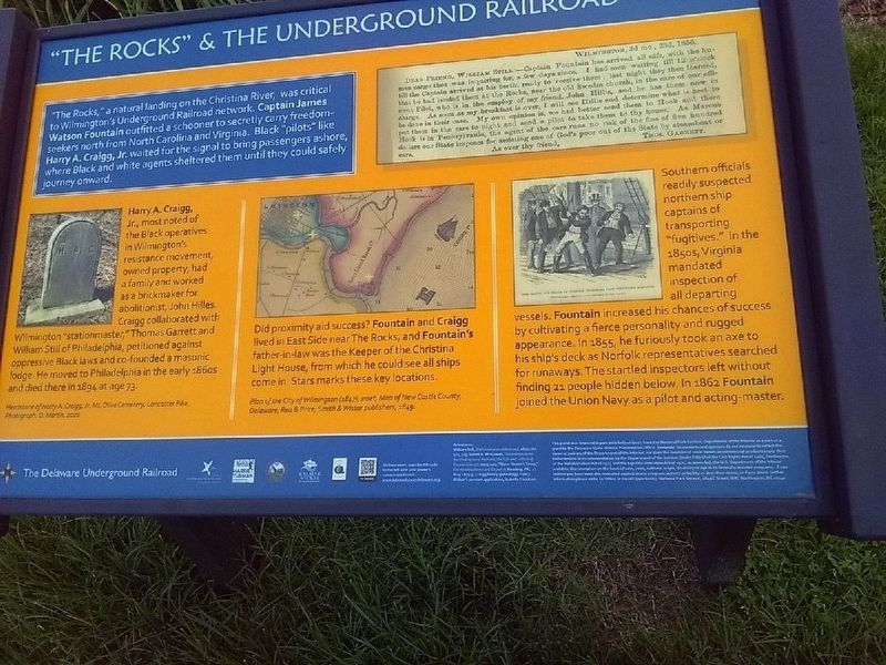
"The Rocks," a natural landing on the Christina River, was critical to Wilmington's Underground Railroad network. Captain James Watson Fountain outfitted a schooner to secretly carry freedom-seekers north from North Carolina and Virginia. Black . . . — — Map (db m226518) HM
While the Choptank River could pose a troublesome barrier to those without a boat, others used the river as a path to freedom.
Josiah Bailey, an enslaved logger and shipbuilder, rowed six miles up the river. His destination was Poplar Neck, . . . — — Map (db m79172) HM
On Crouse Park Lane west of Gay Street (Maryland Route 404), on the right when traveling west.
With more free than enslaved blacks and a sympathetic Quaker population, Caroline County was a hotbed of Underground Railroad activity until slavery was abolished in Maryland in 1864.
Slaves, freemen of color, and whites often . . . — — Map (db m205449) HM
On Market Street at North 2nd Street on Market Street.
Many facets of 19th century rural life focused on a county’s courthouse. Elected officials, lawyers, merchants, and ordinary citizens all had reasons to gather at the Caroline County Courthouse Square. For the enslaved and abolitionists, the . . . — — Map (db m79340) HM
The Choptank River was as entwined with the history of slavery and freedom on the Eastern Shore as any plantation. Slaves arrived by boat for auction and left the dock in the hands of a new owner. At wharves like this, black watermen played an . . . — — Map (db m79342) HM
Growing up as a slave near Easton, MD, Moses Viney often heard, "The wild geese come from Canada, where all are free." When he was 23 years old, Moses learned he might be sold to a new owner in the Deep South. To avoid this fate, he and two . . . — — Map (db m79341) HM
The Quakers, also known as Friends, who met in this Meeting House not only held strong opinions on the abolition of slavery and women’s rights, but they also acted on those beliefs.
After 1790, the Friends who gathered here refused membership to . . . — — Map (db m79354) HM
William Still’s mother Sidney and several of his siblings lived in a cottage on the plantation where they were enslaved. Sidney escaped with her children to join her husband in New Jersey, but she was soon recaptured and returned to Maryland. . . . — — Map (db m79313) HM
On North Main Street (Route 480) just south of Cedar Lane, on the right when traveling south. Reported missing.
More than cargo flowed through commercial towns like Greensboro. Abolitionist ideas and freedom seekers on the move created tension within a society dependent on slavery.
Site of the northern-most bridge over the Choptank River, Greensboro . . . — — Map (db m79356) HM
Gilpin’s Point was one of the busiest wharves along the Choptank River in Caroline County where steamboats and sailing vessels transported people, timber, agricultural products, and seafood. It sat just upriver from Dr. Anthony C. Thompson’s . . . — — Map (db m79311) HM
The forests and waterways of the Eastern Shore, traditional land of the Choptank and Nanticoke Indians, provided the backup for the austere home life, backbreaking labor, and dramatic escapes of enslaved blacks.
Hundreds of acres of white . . . — — Map (db m113807) HM
Harriet Tubman’s parents, Rit and Ben Ross, moved to Poplar Neck in 1847. Her father worked as a lumber foreman on Dr. Anthony C. Thompson’s 2,200 heavily forested acres. Harriet probably made her first escape from this place in 1849, and she . . . — — Map (db m79173) HM
Refugees from slavery came here for temporary sanctuary.
Under the cover of darkness, they crept across these fields toward the home of Quaker Jacob and Hannah Leverton. The house, a rare, documented Underground Railroad station, still . . . — — Map (db m79303) HM
On Linchester Road (Route 817) at Main Street (Maryland Route 331), on the left when traveling west on Linchester Road.
Daily life at and around Linchester Mill provided fertile yet dangerous ground for those seeking freedom.
The mill, a general store, post office and homes at this site brought whites and blacks, free and enslaved, into regular contact. . . . — — Map (db m79299) HM
After Quakers sold their meetinghouse to the local black community in 1849, the new owners established Mt. Pleasant Methodist Episcopal Church. The original church building has since burned, but the modern day congregation still uses the . . . — — Map (db m79178) HM
Common in the mid-19th century, this cabin is a rare survivor today. James H. and Mary Ann Webb built this one-room house in the 1850s, using materials found in the surrounding landscape. Hand-hewn log walls rest on a foundation of ballast stones . . . — — Map (db m79305) HM
On Greenbrier Road, 1.5 miles east of Maple Dam Road, on the right when traveling east.
Harriet Tubman spent some of her childhood on this farm once owned by Edward Brodess. It was here that she experienced the comforts of family and the cruelties of slavery.
Tubman was born a few miles away, on Anthony Thompson's plantation. . . . — — Map (db m205133) HM
Near Bucktown Road at Greenbriar Road. Reported missing.
Dorchester County occupies a central place in the story of the Underground Railroad, the secret network of "stations" and "conductors" that sheltered and shepherded hundreds of enslave African Americans to freedom in the mid-1800s. The famed . . . — — Map (db m126550) HM
On Washington Street (Maryland Route 343) at Ocean Gateway (U.S. 50) on Washington Street. Reported permanently removed.
Harriet Tubman, known as "Minty", was born to Rittia 'Rit' Green Ross, her mother, and Benjamin 'Ben' Ross, her father. Ben and Rit Ross were both enslaved (but to different owners) at the time of Harriet's birth. The number of Harriet Tubman's . . . — — Map (db m109922) HM
On High Street at Spring Street, on the right when traveling north on High Street.
The Call of Freedom
Dorchester County occupies a central place in the story of the Underground Railroad, the secret network of "stations" and "conductors" that sheltered and shepherded hundreds of enslave African Americans to freedom in the . . . — — Map (db m3964) HM
On Washington Street (Maryland Route 343) at Ocean Gateway (U.S. 50) on Washington Street.
The local community, joined by others across the nation, honors its native daughter, Harriet Ross Tubman. Her memory endures through artistic expression in works of literature, music, sculpture, paint, photography, performance, and more. . . . — — Map (db m109915) HM
On High Street north of Court Lane, on the left when traveling north.
One of the oldest buildings in Cambridge, the Caile-Bayly house was built sometime in the mid-18th century. Based on archaeology and analysis by architectural historians, the one-room cabin behind the house appears to have initially functioned as . . . — — Map (db m205040) HM
On Washington Street (Maryland Route 343) at Ocean Gateway (U.S. 50), on the right when traveling east on Washington Street. Reported permanently removed.
Harriet Tubman led many slaves from Dorchester County to Canada (via the suspension bridge at Niagara Falls). One trip with "fugitive slaves" occurred in November 1856, when Tubman conducted Josia (Joe) Bailey, William Bailey, Peter Pennington . . . — — Map (db m109913) HM
As a deep-water tributary of the Chesapeake Bay, the Choptank River was a commercial artery of the Eastern Shore since colonial times. Cargoes of timber, tobacco, and farm harvests were hoisted by dockworkers to waiting ships.
During the . . . — — Map (db m78737) HM
On Church Creek Road (Maryland Route 16) at Bayly Road, on the right when traveling west on Church Creek Road.
In October 1857, ten years before Stanley Institute was established two large groups of enslaved families successfully fled this area.
Caroline and Daniel Stanley and their six children escaped with Nat and Lizzie Amby and six others. Two . . . — — Map (db m114843) HM
On Washington Street (Maryland Route 343) at Ocean Gateway (U.S. 50) on Washington Street. Reported permanently removed.
William Still
William Still (1821- 1902) was born in Burlington New Jersey. His parents had been enslaved on the Eastern Shore of Maryland. To escape slavery, William Still’s parents and their young daughter fled to New Jersey before . . . — — Map (db m117270) HM
Near Golden Hill Road south of Key Wallace Drive, on the right when traveling south.
The Blackwater National Wildlife Refuge, one of over 560 national wildlife refuges, provides critical habitats for native plants and wildlife.
The 17 acres that for the Harriet Tubman Underground Railroad State Park are surrounded by the . . . — — Map (db m114439) HM
On Key Wallace Drive at Visitor Center Access Road on Key Wallace Drive.
It is no accident that for years more fugitives escaped from slavery in Maryland than any other state—the 1850 census recorded 259 runaways. Location played a critical role in these escapes. Networks of black and white abolitionists helped . . . — — Map (db m168865) HM
On Church Creek Road (Maryland Route 16) 0.6 miles south of Brannock Neck Road, on the right when traveling south.
The 125-mile Harriet Tubman Tubman Underground Railroad Byway is the only place in the nation that preserves and interprets the landscapes where Harriet Tubman was born, lived, labored, and fled. In 1849, she liberated herself from the . . . — — Map (db m205114) HM
On Golden Hill Road (Maryland Route 335) 0.1 miles north of Wildlife Drive, on the right when traveling south.
Born nearby on Anthony Thompson's plantation in 1822, Harriet Tubman spent more than 25 years living and laboring amid landscapes like these.
This watery, lowland environment shaped the nature of life here. Tubman learned how to navigate . . . — — Map (db m205119) HM
On Golden Hill Road (Maryland Route 335) south of Key Wallace Drive, on the right when traveling south.
Church Creek sits along MD Route 16, which follows an ancient Indian trail between the Chesapeake and Delaware bays. More enslaved people were able to escape from farms, homes, and businesses along this northbound road than from other parts of . . . — — Map (db m205120) HM
Near Golden Hill Road south of Key Wallace Drive, on the right when traveling south.
Explore the scenic byway, follow the path to freedom and discover Harriet Tubman's rich history.
Experience extraordinary stories of courage along the Harriet Tubman Underground Railroad Byway. With unspoiled landscapes virtually unchanged . . . — — Map (db m114437) HM
Near Golden Hill Road south of Key Wallace Drive, on the right when traveling south.
Discover the extraordinary life and legacy of Harriet Tubman in the landscape of her childhood and early adult life.
Harriet Ross Tubman, an American legendary human rights advocate and suffragist, was born in enslaved in Dorchester . . . — — Map (db m114438) HM
Near Golden Hill Road (Maryland Route 335) south of Key Wallace Drive, on the right when traveling south.
The term "Underground Railroad" originated in the 1830s. It refers to resistance against slavery and acts of self-liberation, escape, and flight. Determining their own fate, runaways from Maryland's Eastern Shore sought refuge in the nearby . . . — — Map (db m205121) HM
During the 1840s and 1850s, the locals knew Reverend Samuel Green as a literate, highly respected Methodist Episcopal preacher and community leader. His church once stood here on land donated in 1843 by free woman Sarah Young. While the building . . . — — Map (db m79150) HM
Harriet Tubman spent her formative years in and around Madison, once called Tobaccostick. As a young woman, she worked for Joseph Stewart in his home and fields, until she joined her father Ben Ross in Stewart’s lumber harvesting operation. . . . — — Map (db m126562) HM
Harriet Tubman was born nearby on Harrisville Road at the Anthony Thompson plantation around 1822, where Thompson enslaved her father, Ben Ross, and about 40 other people. While Tubman’s roots began near here, she moved to Bucktown during her . . . — — Map (db m126547) HM
Founded in 1876 as Jefferson Methodist Episcopal Church, New Revived United Methodist Church was one of five African American congregations established in this vicinity between 1864 and 1880. These churches were rooted in faith communities that . . . — — Map (db m78782) HM