John Hunt Morgan Heritage Trail in Indiana Historical Markers
This series includes 27 John Hunt Morgan Heritage Trail markers detailing the July 1863 Raid ("The Great Raid") of Confederate General John Hunt Morgan through southeastern Indiana.
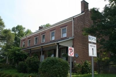
On U.S. 1 at North Dearborn Road, on the right when traveling north on U.S. 1.
On July 13, 1863, General Morgan's raiders looted a tavern in this Community. The Irish-born and agitated proprietor, James Murtaugh, protested, but without any luck. The tavern was an Inn with a dance hall on the second floor, which could be . . . — — Map (db m86240) HM
On North Dearborn Road at Kildeer Lane, on the left when traveling east on North Dearborn Road.
General Morgan and his raiders struck New Alsace on Monday, July 13, 1863. Here at St. Paul Church, Father Roman Weinzapfel was celebrating Mass at 8:30 a.m. when the Raiders stole his horses. Today, the church appears much as it did in 1863. Across . . . — — Map (db m100078) HM
On S. State Street south of Mill Street, on the right when traveling south.
July 8, 1863. Confederate General John Hunt Morgan and 2,000 cavalrymen crossed the Ohio River into Indiana. They were transported from Brandenburg, Kentucky, on two captured steamboats. For six days, the Raiders rode through Southern . . . — — Map (db m66873) HM
On Jamison Road at N. Dearborn Road, on the right when traveling south on Jamison Road.
During the afternoon of July 13, 1863, General John Hunt Morgan crossed the Whitewater River a few hundred yards north of this point. His exhausted men were strung out behind him, but managed to burn the wooden bridge once the straggling ranks were . . . — — Map (db m66875) HM
On S. State Street south of Mill Street, on the right when traveling south.
By July 1863, the American Civil War had entered its third brutal summer. In the East, Confederate forces commanded by Robert E. Lee successfully turned back repeated Union attempts to capture the Southern capital at Richmond. General Lee even . . . — — Map (db m66872) HM
On Capitol Avenue (Indiana Route 337) at Cherry Street, on the right when traveling north on Capitol Avenue.
On July 9, 1863, Colonel Lewis Jordan, Commander of the 5th Regiment, Indiana Legion units (Home Guard) had established a defensive position south of Corydon by 12:30 p.m., General Morgan’s cavalry forces successfully outflanked Jordan's position. . . . — — Map (db m126277) HM
On Otterbein Road SE, 0.2 miles west of Union Chapel Road SE, on the left when traveling north.
On the night of July 8t, 1863, Morgan’s 1st Brigade, commanded by Colonel Basil W. Duke, camped in this area. This brigade, ferried across first, rode northward from Morvin’s Landing, skirmishing along the way with the Indiana Legion. The militiamen . . . — — Map (db m126275) HM
On Morvins Landing Road at Indiana Route 11, on the right when traveling south on Morvins Landing Road.
On Tuesday, July 7, 1863, the first units of General Morgan’s cavalry command arrived at Brandenburg, Kentucky. Their mission was to capture boats to be used for ferrying Morgan’s two thousand men across the 800-1,000-yard-wide Ohio River into . . . — — Map (db m126274) HM
On Indiana Route 135, 0.2 miles north of 2nd Street, on the right when traveling north.
July 8, 1863. Confederate General John Hunt Morgan and 2,000 cavalrymen crossed the Ohio River into Indiana. They were transported from Brandenburg, Kentucky, on two captured steamboats. For six days, the Raiders rode through Southern Indiana. . . . — — Map (db m126220) HM
On Indiana Route 135, 0.2 miles north of 2nd Street, on the right when traveling north.
By July 1863, the American Civil War had entered its third brutal summer. In the East, Confederate forces commanded by Robert E. Lee successfully turned back repeated Union attempts to capture the Southern capital at Richmond. General Lee even . . . — — Map (db m126219) HM
On Greene Street NE (Indiana Route 135) at Church Street, on the right when traveling north on Greene Street NE.
On the night of July 9, 1863, Morgan’s cavalrymen camped in the fields in this vicinity. Following an afternoon of looting in Corydon, they reached this point via two parallel roads by early evening. This site is approximately 25 miles from their . . . — — Map (db m126278) HM
On West Main Street, on the left when traveling north.
On July 11, 1863, General Morgan's main column arrived in Dupont, late in the evening. They traveled approximately 35 miles that day. Most of the Raiders camped at the bend of Camp Creek (#1), near the present day school. General Morgan spent the . . . — — Map (db m100023) HM
On South Old Michigan Road at U.S. 421, on the left when traveling west on South Old Michigan Road.
Hurriedly vacating Dupont early Sunday morning, July 12, 1863, General Morgan's 2,000 cavalrymen headed east. A Dupont resident, Thomas Stout, was commandeered as a guide. The raiders passed numerous farms destroying crops and gathering fresh . . . — — Map (db m100026) HM
On State Road 250 at County Road 140W, on the right when traveling east on State Road 250.
Throughout the day of July 11, 1863, Morgan's Raiders streamed northward from Lexington, passing through Hinesville (now Blocher), Deputy, and Paris. As a diversionary tactic, a regiment of cavalry rode eastward on the Kent Road, creating a sense of . . . — — Map (db m99771) HM
On State Road 3, 0.1 miles south of State Road 7, on the right when traveling south.
Early Saturday morning, July 11, General Morgan and his raiders followed the roads northward from Lexington toward Vernon. At Vernon, Morgan demanded the surrender of the town, but was rebuffed. The Home Guard commander responded that the town was . . . — — Map (db m99774) HM
On West Indian Trail (State Road 350) at County Road 450E, on the left when traveling east on West Indian Trail.
As General Morgan neared Pierceville, an urgent message was sent to Governor Oliver P. Morton reporting the threatening situation. At the time, what is now State Road 350 was a railroad bed. West of this location, detachments of the Raiders burned . . . — — Map (db m100061) HM
On State Road 101 north of Asche Road, on the right when traveling north.
Located on the southeast corner of State Road 101 and County Road 900N stands the Ferris Schoolhouse. The structure still stands and has been converted to a private residence. General Morgan spent the evening of July 12, 1863, inside the school . . . — — Map (db m100075) HM
On Tyson Street at South Washington Street, on the right when traveling east on Tyson Street.
The Morgan Raiders arrived in Versailles at 1 p.m., Sunday, July 12, 1863, and proceeded to rob the county treasury and to obtain fresh horses. The Raiders also captured and paroled 300 local men, who had assembled in hopes of defending Versailles. . . . — — Map (db m100052) HM
On South Cherry Street (State Road 203) south of Walnut Street, on the right when traveling south.
About dusk on July 10, 1863, Brigadier General John Hunt Morgan and his men rode into Lexington, then the county seat of Scott County. The raiders had ridden approximately 45 miles since camping the previous night in the Palmyra area. Lexington was . . . — — Map (db m99756) HM
On Cherry Street (State Road 203) at English Drive, on the left when traveling north on Cherry Street.
On the night of July 10, 1863, most of John Hunt Morgan's cavalry camped along town Creek in these fields. the next morning, while some of the raiders stole what they wanted from Lexington businesses and homes, others scoured the area for horses to . . . — — Map (db m99760) HM
On State Road 356 at Vienna High Street, on the left when traveling east on State Road 356.
In the late afternoon of July 10, 1863, Confederate General John Hunt Morgan's men reached Vienna and seized the Jeffersonville Railroad Station from the agent and telegraph operator. Morgan's telegraph specialist, Lieutenant George "Lightning" . . . — — Map (db m99515) HM
On State Road 356 at High Street, on the left when traveling east on State Road 356.
July 8, 1863. Confederate General John Hunt Morgan and 2,000 cavalrymen crossed the Ohio River into Indiana. They were transported from Brandenburg, Kentucky, on two captured steamboats. For six days, the Raiders rode through Southern Indiana. . . . — — Map (db m99516) HM
On East Canton Road at North Canton Road S, on the right when traveling east on East Canton Road.
On the afternoon of July 10, 1863, General Morgan’s men looted Canton stores and confiscated fresh horses. The raiders continued east from there toward New Philadelphia, crossed the middle fork of the Blue River, and proceeded into Scott County. . . . — — Map (db m126321) HM
On North New Salem Finley Knob Road at Leota Road, on the right when traveling north on North New Salem Finley Knob Road.
This located provides a scenic overlook of the Scott County area. Morgan’s raiders passed here on the afternoon of July 10, 1863. Temperatures were in the 90s and the Raiders were loaded down with much booty. Stolen items included bolts of calico . . . — — Map (db m126322) HM
On S. Main Street (State Road 135) south of Small Street, on the right when traveling north.
On July 10, 1863, shortly before noon, General Morgan entered Salem with two brigades of cavalry. One was commanded by Colonel Basil Duke, his brother-in-law, and the other by Colonel Adam Johnson.
While in Salem, the troops looted, then burned . . . — — Map (db m74080) HM
On Indiana Route 135, 0.1 miles south of East Terrell Lane, on the left when traveling north.
In the early morning of July 10, 1863, General Morgan assembled his cavalry troops and met with his officers at this point. He dispatched a patrol to a railroad four miles to the east. This patrol followed the tracks north, destroying telegraph . . . — — Map (db m126320) HM
On Public Square (South Side) (State Road 135) at South Main Street, on the left when traveling east on Public Square (South Side).
On July 10, 1863 at his headquarters on the southeast side of courthouse square, General Morgan watched the indiscriminate looting of Salem.
Hardest hit was Berkey’s Store on the northwest corner of the square. At Berkey’s more than $1,000 . . . — — Map (db m46794) HM