1752 entries match your criteria. Entries 101 through 200 are listed.⊲ Previous 100 — Next 100 ⊳
E Clampus Vitus Historical Markers
The Ancient and Honorable Order of E Clampus Vitus (ECV) is a fraternal organization dedicated to the preservation of the heritage of the American West, especially the history of the Mother Lode and gold mining regions of the area. More than 1,400 markers point the way to the past.
On September 12, 1861, Jacob Markley staked out a land claim of 160 acres, a parcel that included this site. Markley erected a 16 by 20 foot log cabin somewhere near this plaque, covering it with shakes made from local Sugar Pine. He also built a . . . — — Map (db m157808) HM
On August 2, 1885, fire broke out in the Town of Markleeville destroying several buildings, including Harvey and Rask’s Bucher Shop and Smokehouse. Later on in the Fall, the building was rebuilt and reopened as Rask’s Butcher Shop.
The building . . . — — Map (db m11963) HM
In 1875, the Alpine County seat was moved from Silver Mountain (Kongsberg) to Markleeville. A new jail being needed, a foundation was laid using logs. The iron cells from the old jail were placed thereon and using the mortise and tenon method the . . . — — Map (db m3007) HM
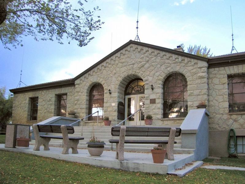
Built by the citizens of Markleeville in 1882 it remained in operation until 1929 when the new Webster School was completed. In 1966, with the old school on the verge of total destruction, the Historical Society of Alpine County began to raise funds . . . — — Map (db m3006) HM
Settled by Scandinavian miners in 1858, - then called Kongsberg. Renamed Silver Mountain in 1863 and made county seat of Alpine County Aug. 11th, 1864. During the Sixties, the town supported a post-office, two newspapers, express office, telegraph . . . — — Map (db m58786) HM
This marks the home of John Albert Thompson (Snowshoe Thompson) great pioneer of the Sierras and hero of the mountains, who for twenty winters carried the mail over the deep snow of the mountains on his long skies: Giving help to those in need along . . . — — Map (db m21302) HM
Markleeville had few amenities during its rollicking youth, though like most respectable
pioneer towns, it boasted a hurdy house. These establishments provided the predominantly
male population a chance to unwind with a drink and possibly . . . — — Map (db m169617) HM
The Raymond Mining District was in operation from 1863 – 1869. It was located roughly four miles north of Silver Mountain and four miles south-west of Markleeville, along Krumm Creek entering Pleasant Valley. Named for R. W. Raymond, who . . . — — Map (db m116092) HM
This plaque is dedicated on September 10, 1960 by the ancient and honorable society of E Clampus Vitus to honor the memory of the early miners, both placer and quartz, of Amador County on the Mother Lode in California.
It marks the place where . . . — — Map (db m10851) HM
In the mineral rich Ione Valley, between Ione and the southern Mokelumne River, where once mining communities like, Lancha Plana, Camp Opra and Camanche dotted the maps, is the town of Buena Vista. Situated at the intersections of two thoroughfares . . . — — Map (db m101437) HM
Old No. 7 was the last steam locomotive to operate over the Amador Central Railroad between Ione and Martell. The twelve mile long railroad lies entirely within Amador County and is one of the shortest railroads in this country. Iron Ivan is a fine . . . — — Map (db m2371) HM
In 1848, Mexican Settlers from Sonora, Mexico established a camp on the north back of the Mokelumne River and called it Sonora Bar. At the start of the California Gold Rush miners flocked to the Mokelumne River and set up camps and towns along its . . . — — Map (db m126094) HM
Judge Smith proclaimed Jackson the Seat of Justice after Clerk Collier canvassed the votes of the May 1851 election in which 1224 votes were cast for Moquelumne Hill and 1014 for Jackson. An armed party from Moquelumne Hill pursued Judge Smith to . . . — — Map (db m27499) HM
Gold changed an entire way of life in California during the Gold Rush. In 1860 Andrew Kennedy and three partners filed 4 mining claims of about 600 feet long. Two shafts were started near what is now Highway 49. The shafts were started, which . . . — — Map (db m101351) HM
Started about 100 years ago as Ryan’s Station. In 1888 became known as Martell’s Station. This was the main terminal for stagecoaches from Amador County gold mines. Large shipments of gold bullion were made from Martell’s Station to San Francisco, . . . — — Map (db m70230) HM
Known as the National Hotel from 1913 to 1962, this hostelry is built over double springs at which earlier gold seekers stopped to refresh themselves. It has been in constant operation since 1862 and has served as a focal point for “community . . . — — Map (db m27670) HM
This monument marks the site of a spring that refreshed the early travelers into this region. So many bottles were found around this spring that some Chilean miners called the site "Bottileas" or place of the bottles, the first name by which the . . . — — Map (db m21371) HM
Since 1850
Has served Jackson Gate since
The California Gold Rush
NRHP Plaque:
Augustino Chichizola's
Store
Has been placed on the
National Register
of Historic Places
By the United States
Department of the . . . — — Map (db m33376) HM
This newspaper was started in Volcano October 27, 1855. It was moved to Jackson in April, 1857. The Amador Ledger is the fourth oldest weekly newspaper in California and the oldest in Amador County. This building became the new home of the Amador . . . — — Map (db m44139) HM
Prospectors in 1849 traveled from the Mokelumne River through Clinton on the way to the diggins in Volcano. In the early 1850’s the camp of Clinton became a market town, supplying the placer miners of the middle and southern forks of Jackson Creek, . . . — — Map (db m100578) HM
D’Agostini Winery was started in 1856 by Adam Uhlinger, a Swiss immigrant. The original wine cellar, with walls made from rock quarried from nearby hills, hand hewn beams, and oak casks, is still in use and part of the present winery. Some original . . . — — Map (db m100585) HM
This hotel is a member of the State of California 100 Year Club and was opened for business in 1860. Bellotti Inn is one of oldest hotels still in continuous operation serving travelers in the State of California. The earliest hotel opened on this . . . — — Map (db m29819) HM
Established in 1869 by Carlo Soracco, the store and adjoining residence were copied from similar buildings in Genoa, Italy. Carlo’s son, Frank, one of Amador County’s leading citizens, became proprietor in 1894. C. Soracco Co. was a major supplier . . . — — Map (db m57992) HM
A man of tremendous ambition, Leland Stanford, Sr., was one of California’s most distinguished businessmen, politicians, philanthropists, and proponents of education. Lured to California by the Gold Rush in 1852, he became an owner of Sutter Creek’s . . . — — Map (db m12610) HM
The jail was built in 1908 to replace the original jail that was destroyed by a fire started when an unidentified inmate set his mattress on fire and burned to death. Sutter Creek and Amador County shared the cost of the new cement jail built by the . . . — — Map (db m57980) HM
At this spot on Plug St. about 100 feet from the intersection of Consolation Ave. is where John Doble chronicled his journey from Indiana, though Central America, up the coast to San Francisco and finally to the gold diggins of Volcano.
His . . . — — Map (db m85859) HM
This plaque is in memory of the pioneers of California who assembled in Volcano where Moose Milk was originated.
Dedicated this 13th day of January, 1951 by E Clampus Vitus.
[A rededication marker, just below the main one, . . . — — Map (db m9055) HM
This plaque is in commemoration of two soldiers of a party from Stevenson’s New York Regiment who discovered Volcano Valley in late 1848 and camped here in Soldier Gulch through a hard winter. Their bodies were discovered in the spring and buried . . . — — Map (db m11364) HM
Built in 1856, the Bavarian Brewery is one of two historic breweries in Volcano, named for brewer Peter Seible. A notable example of early masonry, the precisely cut stones in the front facade are still plumb today. The deep cellar, used for the . . . — — Map (db m200302) HM
The Thomas Starr King Bell was donated to the town of Volcano by Unitarian preacher Thomas Starr King in 1862, who was greatful to the town for its support for the Union and the election of Abraham Lincoln. The bell was originally located at the . . . — — Map (db m101341) HM
[Larger Marker]:
Started 1848 by soldiers of Colonel Stevenson’s Regiment. Named by miners because of apparent volcanic appearance. Here the first California rental library, 1850, was established. And one of the first “Little . . . — — Map (db m100574) HM
Born in Bucks County Pennsylvania, Neal a blacksmith by trade came to California with John Fremont’s second expedition in 1844. After working for John Sutter briefly at New Helvetia, obtained a land grant and established Rancho Esquon. After . . . — — Map (db m61826) HM
On this site the remains of Katie Thompson, Mattie Thompson, and Josie Campbell were laid to rest. The children, were the grandchildren of Joseph Campbell, and all died of Scarlett Fever in 1877. Joseph Campbell was a prominent pioneer in this area . . . — — Map (db m61767) HM
In 1902, Diamond Match Co., established the Butte Co. Railroad. The So PAC tracks ran between Chico, Durham, and Stirling City. Regular train service between Chico and Magalia began Nov. 2, 1903. Magalia depot was completed soon thereafter. April 8, . . . — — Map (db m61223) HM
Named for George Lovelock, born in Wales in 1824, emigrated to California in 1850. George Lovelock settled in Butte County in 1851 and began a successful business in Butte Creek Canyon before moving not far from this present site to establish a . . . — — Map (db m61685) HM
[ Upper Marker ]
This property
Magalia
Community Church
Has been placed on the
National Register
of Historic Places
By the United States
Department of the Interior
[ Lower Marker ]
The Magalia . . . — — Map (db m29609) HM
Site of Gold Rush settlements Long’s Bar, Adamstown, White Rock, and nearby Banner Mine. Sam Neal discovered gold here in 1848. First Christian and Masonic observances in Butte County held here 1849. First county ferry franchise, 1850. — — Map (db m113876) HM
Mining settlement named for
Benjamin Nelson
who discovered gold here in 1850.
Town was on both sides of W. Branch
of N. Fork of Feather River. — — Map (db m113875) HM
Constructed in 1903, this depot is one of three maintained along the Butte County Railroad, a 31 mile line from Chico to Stirling City, completed by Diamond Match Co. in 1904. The railroad was later acquired by Southern Pacific and operated as a . . . — — Map (db m29671) HM
Editor's Note: All the "E's" on this marker are backwards
The historic inn, first built in 1857 by Pat Kelley sold to John Stokes in 1866.
Destroyed by fire in 1868. Rebuilt in 1868, is the only remaining one of five hotels which . . . — — Map (db m61765) HM
This peaceful community, gateway to the remote regions of the High Lakes of Butte and Plumas Counties, owes its origin and subsequent development to the entrance of the Diamond Match Company to California. With the purchase of about 40,000 acres of . . . — — Map (db m61764) HM
September 25, 1882 – August 1, 1968
Founder of Mother Lode Association in 1919, which created colorful Highway 49 – California’s first highway association.
Plaque and 100 year capsules placed on July 23, 1976 by Golden Chain . . . — — Map (db m6876) HM
He was born Sept. 25, 1882 on the old Stevenot Homestead one-half mile west of this marker. Son of Emile K. and Sarah E. Stevenot and the grandson of Gabriel K. Stevenot, Calaveras County pioneer who pitched tent there in April, 1850.
Student, . . . — — Map (db m6847) HM
This building, once owned by Sam Choy, is the only building remaining from a large Chinese settlement here in early Gold Rush days. Now owned by the City of Angels Camp. — — Map (db m31889) HM
Built in the early 1850’s, year not documented, by Frank Egan, as the Central Park Hotel. Then, it included a brothel upstairs. The hotel was sold to Mrs. Mitrovich and renamed The Waverly Hotel. Blagoje “Billy” Ratkovich bought the . . . — — Map (db m40811) HM
In Tribute
To the pioneer craftsman whose skills, ingenuity and determination established permanent communities in the wake of the gold rush, and whose progeny have continued to contribute to the region’s character and spirit, recognition is . . . — — Map (db m58925) HM
Avery one-room school was established April 4, 1886. School was in session from March to December due to winter snows that kept the highway closed.
Hazel Fischer taught here from July 1916 to March 1941. Ms Fischer took all the students to San . . . — — Map (db m53304) HM
The oldest continuously operated hotel in Calaveras County, it was built as a family home in 1851 by Joseph and Sarah Goodell of Maine. The Goodells later relocated to Stockton. In 1853 Peter and Nancy Avery, also of Maine, began operating it as a . . . — — Map (db m20626) HM
July 1875, at Funk Hill 4 miles due east Black Bart, alias Charles E. Bolton or Boles, wearing a flour sack mask and a linen duster, waving a double-barrelled shot gun held up the Wells Fargo Sonora to Milton Stage. The first successful stage . . . — — Map (db m70090) HM
Present site of one of the last family-founded and-still-operated-by-that-family phone companies in America. Founded by Jim Tower, who strung his first telephone wires in 1895 tacked along posts of barb wire fences, earning himself the colorful . . . — — Map (db m57982) HM
With the discovery of copper ore in 1860 by Thomas McCarty and William K. Reed, the town of Copperopolis sprang into existence and soon became the largest producer of copper in the western United States. The population of Copperopolis grew to exceed . . . — — Map (db m13004) HM
Located atop a prominent hill, this cemetery overlooks the community of Copperopolis and it’s surrounding area.
After crossing through the wrought iron gates and walking amongst the paths you’ll find yourself surrounded by the 4 foot natural stone . . . — — Map (db m19759) HM
Josephine Felix arrived from France in 1852, one of the first settlers in Salt Spring Valley. Soon widowed, she established a waystation at the junction of the Angels and Central Ferry Roads. She wed neighbor Alban Hettick and the couple developed a . . . — — Map (db m58929) HM
In the 1860’s Copperopolis had a population of 10,000 and was the principal mine in the west. The mine closed in 1945.
This building has housed a saloon since it was built in 1862. Twice it survived raging fires which destroyed the town.
The bar . . . — — Map (db m19770) HM
Board’s Crossing was first used as a cattle crossing in the early 1870’s. Brothers David and William Board moved here from Missouri in 1854. They settled in Salt Springs Valley and raised cattle. This shallow ford across the river was a favorite . . . — — Map (db m58791) HM
Built in 1860 by John and Rebecca Gardner, this was a stage coach stop on the Big Trees Carson Valley Road. A toll road from 1862 – 1910. The hotel served as a depot for stockmen and as a summer resort.
Noted for its ice cold . . . — — Map (db m57983) HM
Built is 1861 by Antonio and Caterina Gagliardo. Served as a Post Office and social center for the community of Douglas Flat. A hand dug well located next to the store supplied Douglas Flat with good fresh water and remains in good shape today. . . . — — Map (db m58852) HM
A portion of this building served as the Calaveras County Courthouse from 1852 to 1866, when the county seat was removed to San Andreas. George W. Leger then acquired the court building and made it a part of his adjoining hotel, which has been . . . — — Map (db m11537) HM
Beneath this spot in 1851, Joe H. Zumwalt established the first chapter of the Ancient and Honorable Order of E Clampus Vitus. On his way West, Zumwalt discovered an amusing ritual in the newspaper office at Bowling Green, Mo. Arriving in Moke Hill . . . — — Map (db m45976) HM
First American scientist awarded the Nobel Peace Prize (Physics – 1907); Dean of American Optics; Measured velocity of light, ether drift, standard meter, steller diameters. Lived here during childhood. — — Map (db m32818) HM
During the Gold Rush Days of California the organization known as E Clampus Vitas flourished throughout the gold diggings. It was sort of a parody of the solemn and mysterious fraternal orders then so popular in the states. Every member held an . . . — — Map (db m115597) HM
E Clampus Vitus-What mystery and magic that name recalls! Mystery as to its meaning which is unknown; magic as its name conjures the Golden Days of California’s statehood. E Clampus Vitus was established in West Virginia in the 1840’s by Ephraim Bee . . . — — Map (db m122664) HM
Founder of Murphys, 1848.
John and brother Daniel set up trading post; hired Miwok Indians to mine gravel – paid them in merchandise
Murphys was first known as Murphys Diggings; then Murphys Camp – later Murphys
John Murphy . . . — — Map (db m34335) HM
Member of Fremont’s Battalion during Mexican War. Established Indian trading posts throughout Central San Joaquin Valley. Leader of the first expedition of the Mariposa Battalion into Yosemite Valley, 1851
Dr. Lewis Leach described Savage as . . . — — Map (db m34057) HM
The brothers John Murphy (1824-1892) and Daniel Murphy (1826-1882) reportedly pitched their trading tent near this site late in 1848. — — Map (db m51558) HM
Near this spot the “E.C.V. Saloon” stood in 1853. Believed to be the only E. Clampus Vitus (miners’ fun fraternal order) saloon officially recorded. — — Map (db m32875) HM
Built in 1858 by Pierre Bonet with fire proof steel shutters and stone walls. Owned and operated by Victorene Compere to provision the miners. Restored and preserved as a private residence in 1939.
Historic American Building Survey No. 1108 . . . — — Map (db m32872) HM
William Gordon Huff
1903 ~ 1993
Sublime Nobel Grand Patriarch
Grand Clamp Artist
Visionary • Artist • Sculpture
Bill conceived, named, and created
E Clampus Vitus Wall of Comparative Ovations
as a memorial to portray early . . . — — Map (db m31195) HM
At this place, April 30th 1892, without warning, a lone bandit fired two charges of buckshot into the stage carrying the payroll for the Sheepranch Mine. Miss Johanna Rodesino, a passenger, was instantly killed. Babe Raggio, driver, was severely . . . — — Map (db m11683) HM
In this cemetery lie the remains of 600 Calaveras pioneers. All died in the once adjacent county hospital and were interred here between 1890 and the 1910’s. Mostly older men, they lacked the means to be buried in a church or town cemetery. Some . . . — — Map (db m19324) HM
The Red Barn Museum is the only remnant of The Calaveras County Hospital that remains on these grounds. The two-story hospital was built in 1870, and remained in use until Mark Twain Hospital was constructed in 1951. This building served as the . . . — — Map (db m102244) HM
The discovery of gold in 1860 on George Johnson's Sheep Ranch, by Harvey Childers led to the birth of the community. In the 1870's the town included a Catholic and Protestant Church, a post office, a two teacher school with 30 students, and the . . . — — Map (db m102263) HM
First located in 1867, the fabulous Sheep Ranch Mine produced more than 8 million dollars in gold while in operation. Aquired in 1877, by senator George Hearst, K.B. Haggin and associates. It was operated continuously by the Hearst firm until 1893, . . . — — Map (db m102288) HM
For more than 80 years, the area was known as Onion Valley due to the profusion of wild onions growing here. It was mainly used as a summer stock range. In the late 1860-70’s a sawmill was operated by C. Brown. Later a man called “Turkey” Johnson . . . — — Map (db m40974) HM
From New York in 1900 to the present day in California; from cookhouse to firehouse this bell has been a part of Vallecito’s history.
In 1906, Beach Thompson needing water for his hydraulic mining, and investors in San Francisco needing . . . — — Map (db m32727) HM
The store was built in 1851 and opened for business in 1852 by the Dinkelspiel family, who had recently emigrated from Germany. The buildings were made of rhyolite tuff blocks from the Altaville Quarry. The small adjoining building originally used . . . — — Map (db m11967) HM
The original three foot narrow gauge line was built by the San Joaquin & Sierra Nevada Railroad, extending from Brack’s Landing on the Mokelumne River, east to Valley Springs. The depot and turntable were built around the time of completion of the . . . — — Map (db m10635) HM
In 1859 Tacitus Ryland Arbuckle located a homestead in the Sacramento Valley, and in 1875 had the land plotted for a town site. The legendary Arbuckle founded the town, deeded the lots, furnished the nails, and helped build the first houses in what . . . — — Map (db m54548) HM
This house, also called the Tin House because of its pressed metal siding has a symmetrical façade that is suggestive of a Colonial Revival influence. In the 1890’s a flour mill was located on this site but eventually closed because of continued . . . — — Map (db m72987) HM
In the 1850s, Chinese came to California, a land they called Gum Shan, meaning Mountain of Gold, for the same reason as other nationalities: to seek their fortune. As the placer gold played out, Chinese took jobs building railroads, dams, levees, . . . — — Map (db m54986) HM
The property upon which this house sits has been owned by several notable California pioneers including John Bidwell and Charles D. Semple. It is unknown who built this house and exactly when. It is known however that the first resident of the house . . . — — Map (db m118596) HM
Squire Silas Stone emigrated with his family from Iowa in 1853 and settled half mile east of this marker. The pioneer's home stood nearby until 1957. His son Albert eventually expanded the ranch to 800 acres and gave the family name to the present . . . — — Map (db m93667) HM
You protected us on the field of battle. You watched over our eternal rest. You will not be forgotten. We are forever grateful.
Dedicated in memory of Specialist 4th Class George D. (Doug) Deitrick and his scout dog, Egor (75IM), . . . — — Map (db m93604) WM
From 1860 to 1906, this area was the largest coal mining district in California. Five towns (Nortonville, Somersville, Stewartville, Judsonville and West Hartley) grew up around twelve major mines. Today the towns are gone. The buildings having been . . . — — Map (db m139449) HM
This was the first high school constructed in Contra Costa County. Supported by the Womans Club of Antioch, the first joint communities bond was passed in 1908 for $20,000 by Antioch, Pittsburg, Somersville, Nortonville and Live Oak.
Charles . . . — — Map (db m91845) HM
This area was the original site of the coal mining town of Somersville. The town was located here because of the availability of good drinking water. When the railroad arrived in 1866, water could be hauled from the San Joaquin River and the town . . . — — Map (db m93608) HM
Eleven women founded the Woman's Club of Antioch in February, 1902. They pledged to "improve and beautify the town, to do any business which shall promote the educational, industrial, benevolent, social or political welfare of its members or the . . . — — Map (db m93605) HM
This house, which serves as the museum for the East Contra Costa Historical Society, was originally built by Johnson and Elizabeth Fancher in 1878. In the early 1880's the Fanchers sold the house and surrounding acreage to John and Letitia Byer. In . . . — — Map (db m94652) HM
At this location, in 1878, a railroad station was established for the San Pablo and Tulare Railroad, which ran from Los Banos to Martinez, later to become part of the Southern Pacific Railway, for the purpose of taking on water, and became known as . . . — — Map (db m17325) HM
The history of this property dates to 1858, when George Chapman built and operated a two-story hotel with an apartment on a third floor. It was the site of Clayton's first Post Office. Following a fire in 1864, a new building was constructed in 1867 . . . — — Map (db m150415) HM
Born in Mexico in 1832 the renowned "Robin Hood of the El Dorado" spent his early days in Californa working in Contra Costa County as a vaquero before turning bandit.
Dedicated By
Joaquin Murrieta Chapter No. 13
E Clampus Vitus
November . . . — — Map (db m24567) HM
As early as 2000 BC, this area was home to the Volvon Miwok Native Americans. Many artifacts of their lifestyle were found when American settlers arrived in the 1800s.
Under the Homestead Act between 1862 and 1872, Clayton's founder, Joel Clayton . . . — — Map (db m150414) HM
This area in the mid 1850s, was a known hideout for legendary bandit Joaquin Murrieta, who worked as a vaquero for John Marsh on his rancho just east of here. It was also frequented by John "Grizzly" Adams, famed California mountain man.
In 1927 . . . — — Map (db m94657) HM
Jacob Rhine's National Saloon had an impressive inventory of cigars and liquor in 1874.
The saloon was renamed after Carl Berendsen bought the property in 1905. He added a building shipped from San Francisco via Martinez for family living . . . — — Map (db m57976) HM
Joel Clayton owned the property facing Morris Street from 1857 to 1870. His estate sold the lots to J. H. Keller in 1877 who built a house, slaughter house, butcher shop, and barn.
George Scammon owed most of the remaining lots and planted . . . — — Map (db m150416) HM
Don Salvio Pacheco granted this land designated as a cemetery to serve Clayton and Concord. There are many prominent pioneers of early Clayton and Concord buried here. They include members of the following families: Atchinson, Babel, Clayton, . . . — — Map (db m93630) HM
1752 entries matched your criteria. Entries 101 through 200 are listed above. ⊲ Previous 100 — Next 100 ⊳