14 entries match your criteria.
Virginia, Clinch River Forts Circa 1774 Historical Markers
Palisaded forts, some built on Virginia Governor Lord Dunmore’s order, for settler protection during “Lord Dunmore’s War” with the Cherokees.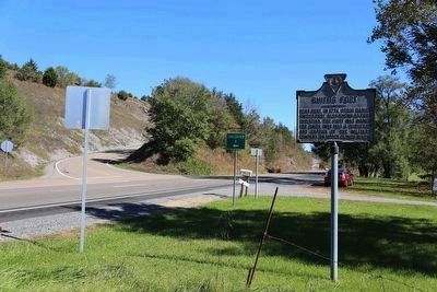
By J. J. Prats, October 18, 2015
Smith’s Fort Marker on Northbound U.S. 19 at Crossover A
| 1 ► Virginia, Russell County, Belfast Mills — XY-17 — Smith’s Fort — |
| 2 ► Virginia, Russell County, Castlewood — X-7 — Russell’s Fort — |
| 3 ► Virginia, Russell County, Dickensonville — KA-13 — Dorton’s Fort — |
| 4 ► Virginia, Russell County, Elk Garden — X-9 — Elk Garden Fort — |
| 5 ► Virginia, Russell County, Lebanon — X-8 — Glade Hollow Fort — |
| 6 ► Virginia, Russell County, Mew — X-18 — Moore’s Fort — |
| 7 ► Virginia, Scott County, Dungannon — K-18 — Patrick Porter — (1737–1805) — |
| 8 ► Virginia, Scott County, Gate City — K-13 — Blackmore’s Fort — |
| 9 ► Virginia, Scott County, Glenita — KA-7 — Carter’s Fort — |
| 10 ► Virginia, Scott County, Snowflake — K-17 — Houston’s Fort — |
| 11 ► Virginia, Tazewell County, Frog Level — X-16 — Indian-Settler Conflicts — |
| 12 ► Virginia, Tazewell County, Liberty — XY-13 — Maiden Springs Fort — |
| 13 ► Virginia, Tazewell County, Pisgah — XY-14 — Big Crab Orchard Or Witten’s Fort — Reported missing |
| 14 ► Virginia, Tazewell County, Tazewell — X-10 — William Wynne’s Fort — |