The Mississippi Mound Trail project is a self-guided driving tour located along or near Highway 61 in the Mississippi Delta. The trail route parallels the Mississippi River. The Mississippi Mound Trail has 33 historical markers.
On Jeff Davis Boulevard east of South Temple Road, on the right when traveling east.
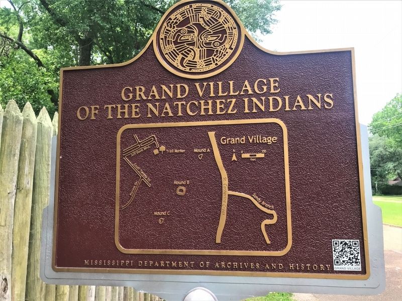
Of the six mounds identified on the early 18th-century maps of the Grand Village, three remain. Mound A is now eroding into St. Catherine Creek. Mound B is a pyramidal platform mound, roughly seven feet tall, built in four stages. Each stage served . . . — — Map (db m103758) HM
On Emerald Mound Road, 1 mile west of Natchez Trace Parkway, on the right when traveling west.
Covering roughly eight acres, Emerald Mound is the second largest Mississippian mound north of Mexico. The main platform was constructed in three stages beginning ca. AD 1350. Archaeological excavations have confirmed that the first and second . . . — — Map (db m97256) HM
On Foster Mounds Road, 0.5 miles south of Steam Plant Road, on the right when traveling north.
Foster Mounds consists of two mounds located on either end of a large village or plaza. Mound A was built in four stages during the Plaquemine Period, sometime after AD 1400. Its original size and shape have been modified to accommodate the late . . . — — Map (db m105230) HM
On Mississippi Route 1 north of Clark Place, on the right when traveling north.
Christmas Mound is a single conical mound
approximately ten feet in height. Archaeological
excavations in 2013 determined that the mound was built
in a single stage on top of an earlier midden deposit. The
midden dates to ca. AD 400, but the . . . — — Map (db m173987) HM
On Old Mill Road, 0.4 miles south of Bald Hill Road, on the right when traveling south.
Of the three original mounds overlooking Bayou Pierre, only one remains. A pyramidal platform, Mound A is currently 16 feet tall. Excavations indicate that Native Americans built the mound in multiple stages during the Coles Creek Period, from AD . . . — — Map (db m103785) HM
On Rodney Road, 1.6 miles west of Montgomery Road, on the left when traveling west.
Windsor Mounds includes four rectangular platform mounds overlooking Bayou Pierre. Mound A, visible from the road, is the largest at over 30 feet, and has a ramp extending toward the east. Mounds B, C, and D range in height from 3 to 16 feet. The . . . — — Map (db m103783) HM
On Coahoma-Rich Road, 0.9 miles south of U.S. 61, on the right when traveling south.
When first recorded, Salomon Mounds had three (possibly four) large platform mounds and as many as eight smaller mounds arranged around a central plaza. The smaller mounds have been plowed away, while one of the large mounds was destroyed in 1958 . . . — — Map (db m107621) HM
On State Highway 6, 0.5 miles east of Crum Road, on the right when traveling east.
The Dunn site consists of three earthen mounds. Mound A is oval in shape and just over sixteen feet in height. Mounds B and C have ben diminished by erosion and are less than three feeet in height. Archaeological excavations in 2013 indicate that . . . — — Map (db m154827) HM
On Norfolk Road, 0.1 miles east of Thomas Road, on the right when traveling west.
The Edgefield site consists of three conical earthen mounds arranged on a northwest-southeast axis. The two largest mounds are roughly 20 feet in height, while the third is just under ten feet. Much of the surrounding soil has been removed for use . . . — — Map (db m234537) HM
On U.S. 49, 8.8 miles north of Interstate 220, in the median.
The Pocahontas site consists of two mounds and an
associated village area. Mound A is a rectangular platform
mound currently 20 feet tall, built between AD 750 and
1500. Excavations located structural features on the mound
surface, as well . . . — — Map (db m121103) HM
On Mississippi Route 7, 0.5 miles south of Smith Road, on the right when traveling south.
Jaketown is the site of some of the earliest Indian earthworks
in Mississippi. Of eighteen mounds recorded, only Mounds
A, B, and C are still visible. The earliest stages of Mound A
were built in the Late Archaic/Poverty Point Period . . . — — Map (db m235137) HM
On Grace Road, 0.3 miles west of State Highway 1, on the left when traveling south.
Of the five original mounds located on the eastern bank of Steele Bayou, only Mounds A and B survive. At 40 and 16 feet respectively, Mounds A and B were built using a technique called basket loading. Archaeological excavations found evidence of at . . . — — Map (db m154734) HM
On Deer Creek Road, 1.6 miles east of U.S. 61, on the right when traveling east.
Aden Mounds consists of three mounds surrounding a rectangular plaza, the fourth side open to Jeff Davis Bayou. Mounds A and B are rectangular platform mounds nearly 10 feet in height. Mound C is no longer visible, but archaeologists discovered its . . . — — Map (db m154464) HM
On Mississippi Route 35N, 0.5 miles south of Interstate 55, on the right when traveling south.
Seven mounds were originally recorded at the Batesville site. Of these, two remain intact. Mound B is a rectangular platform mound nine feet high; Mound C is a conical and stands 20 feet high. Mounds A and D have been greatly reduced by plowing but . . . — — Map (db m102575) HM
On Creek Road, 0.3 miles west of Barfield Road, on the right when traveling west.
The Anguilla site consists of a single rectangular
platform mound located on the south side of Deer Creek.
The mound is currently 20 feet in height, but originally
may have been taller. It was constructed by Native
Americans during the Late . . . — — Map (db m235138) HM
On Crab Apple Lane at Willow Lane, on the right when traveling north on Crab Apple Lane.
Of the original four mounds located at the Cary site, only Mound A survives. Located on the south side of Deer Creek, the mound was built on top of a midden deposit containing ceramic and animal bone artifacts as well as a fragment of a stone . . . — — Map (db m157616) HM
On Deer Creek Road, 0.4 miles south of State Route 16, on the right when traveling south.
The Carter site consists of two earthen mounds separated by
a plaza area. Mound A was built in at least two stages and is
13 feet tall. Mound Bis a burial mound and stands at just
under seven feet tall. Both mounds are roughly six feet . . . — — Map (db m157608) HM
On Rolling Fork Road south of Helena Road, on the right when traveling south. Reported missing.
Mont Helena may have had as many as three mounds in the past. The remaining mound is 26 feet high, but its original dimensions were even more impressive. Roughly 10 feet of mound fill was removed around 1900 prior to the construction of the Colonial . . . — — Map (db m170694) HM
On U.S. 61, 0.5 miles south of West Avenue, on the right when traveling south.
Rolling Fork Mounds consisted of three earthen mounds, all
of which have sustained significant damage since they were
first described in 1926. At that time, Mound A was 38 feet
tall, Mound B was 20 feet tall, and Mound C was less than
two feet. . . . — — Map (db m157533) HM
On Old U.S. 61, 0.8 miles south of Evansville Road, on the right when traveling south. Reported missing.
There are currently two mounds located at the Beaverdam site, though there may originally have been more. Mound A has eroded over time and is now 11 feet tall. Early 20th-century accounts describe it as rectangular in shape with a two-tiered . . . — — Map (db m116174) HM
On Austin Road, 0.2 miles west of Old U.S. 61, on the left when traveling west.
Located on the eastern bank of the Beaverdam Lake, the Evansville site originally had at least four earthen mounds. Today, only Mounds A and B remain. When first recorded, Mound A had a two-tiered platform—the west side was roughly 18 feet tall and . . . — — Map (db m116171) HM
On Indian Mound Road, 1.5 miles west of Old U.S. 61, on the right when traveling west.
Hollywood Mounds originally consisted of a large platform mound surrounded by a series of smaller mounds. At 20 feet in height, Mound A is the site's central feature and was once enclosed on three sides by connected mounds forming an embankment. . . . — — Map (db m116166) HM
On Old U.S. 61, 0.5 miles south of Hollywood Road, on the right when traveling south.
The Johnson Cemetery site currently consists of a single mound and associated village, but may originally have had a second mound. The existing mound is 12 feet high in height and was most likely pyramidal in shape, though its dimensions have . . . — — Map (db m116168) HM
On Silver Bullet Boulevard near State Route 3, on the left when traveling north. Reported missing.
Haynes Bluff originally consisted of one large and three smaller platform mounds surrounding a plaza. Mounds A and C remain, while Mounds B and D were destroyed in 1967. Mound A, the largest at the site, was originally 30 feet tall and has a ramp . . . — — Map (db m157666) HM
On U.S. 61 south of Demby Drive, on the right when traveling south.
The Glass site originally consisted of four pyramidal mound surrounding an open plaza, with a possible fifth mound located to the north. Of these, Mound A alone remains undamaged. It stands 30 feet high and has a ramp extending south toward the . . . — — Map (db m103780) HM
On Yazoo Refuge Road, 1 mile east of State Highway 1, on the right when traveling east.
The Law site originally consisted of three earthen mounds. Mound A, the largest of the mounds and the one to survive, is just under 20 feet tall and has a ramp facing south toward a plaza area. Mound B was originally 13 feet tall and was located . . . — — Map (db m154742) HM
On Yazoo Refuge Road east of Deer Lake Road, on the right when traveling east.
Of Swan Lake's four original mounds, three were arranged in a line running parallel to the lake. Of these, only Mound B is visible today. Mound A is located a short distance to the northeast. Sixteen feet in height, Mound A is oblong in shape and . . . — — Map (db m154741) HM
On State Highway 1 north of Indian Road, on the right when traveling north.
Winterville Mounds was an important political and religious center during the Mississippi (ca. AD 1200-1450). First occupied during the Coles Creek Period, beginning around AD 1000, the site originally had as many as 23 mounds, the largest of which . . . — — Map (db m154826) HM
On State Highway 24, 0.5 miles north of Millbrook Road, on the right when traveling east.
The Smith Creek site consists of three mounds surrounding a large plaza. Mound A is the site's largest monument, at over 30 feet. Mound B is a burial mound surrounded by a ditch or moat. Mound C, to the east, is eroding into Smith Creek; its . . . — — Map (db m96735) HM
On State Highway 24 west of Pleasant Valley Road, on the right when traveling west.
The Lessley site consists of one large, rectangular platform mound. Excavations in 2013 determined that the mound was built in two or more stages, beginning in the Late Coles Creek or Early Plaquemine Period, ca. AD 1100-1350. Based on excavated . . . — — Map (db m96644) HM