On E Freemason St, on the right when traveling west.
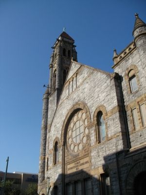
This 1894 Richardsonian Romanesque granite and sandstone church was designed by Norfolk architects James E. R. Carpenter and John V. Peebles. It was built to accommodate the growing congregation of the 1850 Granby Street Methodist Church at the . . . — — Map (db m3372) HM
On Boush Street north of W Main Street, on the right when traveling south.
Tidal flooding from hurricanes and northeasters has always been a part of Norfolk’s relationship with the sea. In 1693, the Royal Society of London reported that “there happened a most violent storm in Virginia, which stopped the course of . . . — — Map (db m3374) HM
Hostilities between the British and the Dutch continued for a number of years after the British took New Amsterdam in 1664 and established the colony of New York. The effects were felt in Hampton Roads where Dutch ships destroyed a fleet of tobacco . . . — — Map (db m21212) HM
In 1641 a “chapel of ease” was built here where St. Paul’s Church is now. The 1680 survey of the new town designated this site for a church and burying ground. Many of the founders of Norfolk are buried here. When Norfolk became a . . . — — Map (db m3371) HM
A cedar tree near this location, then known as Foure Farthing Pointe, was described in the original patent defining the western boundary of the 50 acres that comprised Norfolk Town. In August 1680 John Ferebee, surveyor for Lower Norfolk County, was . . . — — Map (db m3409) HM
On March 8, 1862 CSS Virginia steamed past this point (1) to a battle which would forever change naval warfare. This ship had previously been a Union steam frigate, USS Merrimack, which had been destroyed near the Gosport Navy Yard . . . — — Map (db m200157) HM
Battleships bearing the name Wisconsin have graced the waters off Norfolk and Hampton Roads since the beginning of the twentieth century. Ornately designed to show-off the “Stars and Stripes” of the United States, the first battleship . . . — — Map (db m203276) HM
Redefining the skyline of downtown Norfolk, battleship Wisconsin stands stoically with dominating presence. After months of dredging and construction, Wisconsin majestically slipped into the seemingly tailored berth without a hitch on . . . — — Map (db m203277) HM
Battleship Wisconsin and the sister-ships of the Iowa Class arguably hold a symbolic status as monuments in naval surface warship design. Unlike torpedo boats, tin-can destroyers, flat-top aircraft carriers, and pig-boat submarines, . . . — — Map (db m3378) HM
The Armed Forces Memorial is located here on a river that has for more than 200 years carried servicemen off to war and returned them home to loved ones. Within the Memorial are 20 inscriptions from letters written home by U.S. service members who . . . — — Map (db m3475) HM
Off this point in the Elizabeth River is the zero mile buoy marking the beginning of the Atlantic Intracoastal Waterway. In colonial times water transportation was the principal mode for moving cargo. The idea of a canal connecting the Elizabeth . . . — — Map (db m3478) HM
In the 1950s the downtown waterfront contained an assortment of aging facilities-wharves, warehouses, rail lines, ship chandlers, tugboat operations, and ferry docks. The city of Norfolk made a significant decision. An area of downtown along the . . . — — Map (db m3480) HM
Navy Escort Carriers based in Norfolk helped win the Battle of the Atlantic. They were the smallest, slowest, and most vulnerable of the Navy's aircraft carriers, but as noted World War II historian Samuel Eliot Morison wrote, "These escort carrier . . . — — Map (db m21213) HM
After northern states began abolishing slavery during the Revolutionary era, fugitives from throughout southeastern Virginia and northeastern North Carolina started to escape by ship from the Norfolk waterfront. With luck and determination, many . . . — — Map (db m5602) HM