1002 entries match your criteria. The first 100 are listed. Next 100 ⊳
Montana National Register Sign Program Historical Markers
Aluminum plaques "Listed in the National Register of Historic Places by the United States Department of the Interior in cooperation with the Montana Historical Society."
On Bannack Road near State Highway 278, on the left when traveling east.
Sidney Edgerton arrived at Bannack from Ohio in September 1863 to begin his appointment as Chief Justice of the Supreme Court of Idaho Territory. The massive territory encompassed Idaho, all of Montana, and the western half of Wyoming, with the . . . — — Map (db m124263) HM
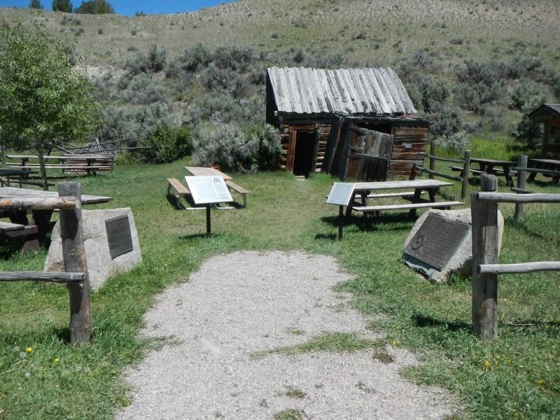
Near Bannack Road (State Highway 278), on the left when traveling east.
Bannack epitomizes the tough, primitive towns that sprang up with gold discoveries. Its story also illustrates a century of survival, through boom and bust periods associated with resource extraction and technological advances. On July 28, 1862, . . . — — Map (db m124262) HM
On East Center Street near North Idaho Street, on the left when traveling south.
The four buildings that make up this small historic district show the growth of Dillon’s city government. Buildings include ones constructed in the Progressive Era, the New Deal, and the 1960s, when the city built a shelter for one of its water . . . — — Map (db m180751) HM
On South Pacific Street at East Clark Street, on the right when traveling west on South Pacific Street.
The Martin Barrett House, built in 1912, was the in-town retirement home of prominent pioneer rancher, politician and philanthropist Martin Barrett and his wife Alice. One of the finest examples of early-twentieth-century architecture in Dillon, the . . . — — Map (db m209432) HM
On North Custer Avenue near Fifth Street West when traveling north.
Building contractor Ernest Adler constructed these attached, flat roofed storefronts between 1914 and 1920. A German immigrant, Adler was one of Hardin’s most prolific builders. Situated on the edge of the business district, the one-story brick . . . — — Map (db m189252) HM
On West Third Street (Old U.S. Highway 87) at North Crow Avenue, on the right when traveling west on West Third Street (Old U.S. Highway 87).
Hardin women began raising money for a library in 1909. Numerous fundraisers followed, and in 1912 a hundred-book library opened in the home of Walter and Ella Fearis. After the city passed a mill levy in 1914, Walter Fearis wrote library benefactor . . . — — Map (db m189329) HM
On North Custer Avenue at 5th Street West, on the right when traveling north on North Custer Avenue.
Hardin women began raising money for a library in 1909. Numerous fundraisers followed, and in 1912 a hundred-book library opened in the home of Walter and Ella Fearis. After the city passed a mill levy in 1914, Walter Fearis wrote library benefactor . . . — — Map (db m189254) HM
On East Railway Street near North Central Avenue, on the right when traveling east.
Hardin’s first railroad depot was moved from Fort Custer after being cut into small sections and transported by train over the Big Horn Bridge. That depot was expanded in 1909, but was deemed inadequate after the homestead boom dramatically . . . — — Map (db m189370) HM
On West Third Street (Old U.S. Highway 87) near North Chouteau Avenue, on the left when traveling west.
As Hardin’s residential neighborhoods began to take shape during the 1910s and 1920s, the new Craftsman style emerged as a favored design. Its popularity was partly due to the ready availability and low cost of the machine-made, mass-produced . . . — — Map (db m189330) HM
On North Crawford Avenue near West 6th Street, on the left when traveling north.
In 1900, John Svaren left his home in Bergen, Norway, to join family in South Dakota. There he learned English before homesteading to North Dakota in 1909. With his bride, Betsy, Svaren arrived in Hardin in 1917 to build a home. He applied his . . . — — Map (db m189331) HM
On North Central Avenue near West 3rd Street (Old U.S. Highway 87), on the right when traveling north.
Long before fur trappers entered the Bighorn Valley, Crows, Sioux, and Cheyennes vied for the area’s abundant game. In 1876, Sioux and Cheyenne warriors defeated the U.S. Army at the Battle of the Little Bighorn; the following year, the Army . . . — — Map (db m189333) HM
On North Central Avenue at 2nd Street West, on the left on North Central Avenue.
German immigrant Anton Becker had great faith in Hardin’s future. Becker bought this lot on May 30, 1907, the day town lots went on sale. He soon constructed a two-story brick building, in front of which he installed Hardin’s first cement sidewalk. . . . — — Map (db m189367) HM
On North Central Avenue near 2nd Street West, on the left when traveling north.
The elaborate corbelling on the front façade and the parapet above the transom evoke the glory days of this building, which long provided recreation for Hardin residents. German immigrant Anton Becker, owner of the hotel next door, constructed the . . . — — Map (db m189365) HM
On West 4th Street near North Central Avenue, on the left when traveling west.
Montana created twenty-six counties during its 1910 county-splitting craze. Among them was Big Horn County, carved from portions of Yellowstone and Rosebud Counties in 1913. Private entrepreneurs constructed the new county’s first courthouses. In . . . — — Map (db m189332) HM
On North Central Avenue near Second Street West, on the left when traveling north.
Charles and Rushann Schneider built this two-story brick business block in 1910. Anticipating the arrival of electricity by four years, the Schneiders had their building wired during its construction. The exterior’s relative simplicity reflects the . . . — — Map (db m189363) HM
On North Custer Avenue near 8th Street West, on the left when traveling north.
St. Joseph’s Catholic Church of Hardin was founded by Jesuit missionaries to the Crow Indians. Fr. Thomas Grant of St. Francis Xavier’s Mission purchased three town lots for $425 in 1908. The Jesuits constructed a plain, gable-front wooden building . . . — — Map (db m189251) HM
On West Third Street (Old U.S. Highway 87) near North Central Avenue, on the left when traveling west.
On May 4, 1917, Hardin celebrated the “formal opening of the Gay block . . . with a grand ball in the south store room of this magnificent structure.” The storage area’s hardwood floor was perfect for dancing, and construction of the two-story brick . . . — — Map (db m189361) HM
On Bypass U.S. 287 near Slifka Lane, on the right when traveling west.
Norwegian immigrant Tom Toston established a ranch and ferry near here in 1871. Strategically located at the junction of the Helena-Gallatin Valley Road and the road to Radersburg, a settlement quickly grew up around Toston’s ranch. Soon the town . . . — — Map (db m188779) HM
On Broadway (U.S. 12) near South Cedar Street, on the right when traveling north.
J. P. Kearns came to Townsend from Benton, Wisconsin, in 1899. Business-educated and experienced, Kearns astutely recognized the town’s need for a new financial institution and founded the State Bank of Townsend only three months later. The bank was . . . — — Map (db m141732) HM
On South Spruce Street at B Street, on the right when traveling north on South Spruce Street.
On December 5, 1875, Masons in Meagher County chartered Valley Lodge No. 21 (A.F. & A.M.) in Centerville, a farming community just north of present-day Townsend. The lodge moved to Townsend in 1884, shortly after the Northern Pacific Railroad . . . — — Map (db m188781) HM
On State Highway 308, 1 mile east of South 6th Street, on the left when traveling west.
A large red granite monument commemorates the 75 miners who died in the 1943 explosion at the Smith Mine. The United Mine Workers of America installed this memorial in 1947 to memorialize Montana’s worst coal mining disaster. Twenty-two of the Smith . . . — — Map (db m190162) HM
On Main Street (State Highway 308) at South 2nd Street, on the right when traveling west on Main Street.
A coal-mining town established in 1905, Bearcreek developed quickly, and after just one year the town boasted telephones, city water, and electric streetlights. Bert Vaill, a cashier with the Carbon County Bank of Red Lodge, purchased this lot from . . . — — Map (db m190148) HM
On State Highway 308, 0.1 miles west of Scotch Coulee Road, on the right when traveling west.
Thirty-nine corrugated metal structures mark the site of the Smith Mine, a ghostly reminder of a once vibrant mining district. The Montana Coal and Iron Company (MCI) began developing the Smith Mine in earnest after the arrival of the Montana, . . . — — Map (db m190143) HM
On South 1st Street at U.S. 212, on the left when traveling north on South 1st Street.
“Chief shepherd” Walter Jordan and “singing evangelist” Lucile Park preached to a packed house at an October 1908 revival meeting, held above the meat market on Joliet’s Main Street. Forty-five charter members joined together to found the Joliet . . . — — Map (db m190744) HM
On Main Street at East Central Avenue, on the left when traveling north on Main Street.
The Bank of Joliet opened in 1904 and began planning construction of this stately one-story building soon after. By the time the $8,000 building was completed in 1907, the bank had new owners and a new name. Built on Joliet’s most visible corner, . . . — — Map (db m190745) HM
On North Broadway Avenue (Route 212) south of 9th Street, on the right when traveling south.
Local physician Dr. Samuel Souders owned this commercial lot in 1909 when Dan Davis, an advocate for the construction of a fancy opera house, proposed it for the construction of his vision. The newspapers reported weekly for several months on Davis’ . . . — — Map (db m45384) HM
On Hauser Avenue North near 5th Street West, on the right.
The manager of the Red Lodge Brewery, Paul Lehrkind, purchased this lot in 1920, likely with the intent of building a home. However, despite efforts to survive Prohibition by manufacturing the “near beer” Bud-O (“Always on Top”), Lehrkind was forced . . . — — Map (db m190277) HM
On North Broadway Avenue (U.S. 212) south of 11th Street, on the right when traveling south.
A combination moving picture theater and boarding house were the original tenants of this two-story masonry building, completed in 1908. Several directors managed the rather short-lived Alcazar, including Steve Roman, whose family long monopolized . . . — — Map (db m45387) HM
On Hauser Avenue North near 7th Street West, on the left when traveling north.
Over a quarter of the houses in the elite “Hi Bug” neighborhood were built between 1900 and 1901, including this one-and-one-half-story home, erected as a real estate investment by Red Lodge merchant Walter R. Hall and his wife Louisa. After leasing . . . — — Map (db m190244) HM
On North Broadway Avenue (U.S. 212) north of 10th Street, on the right when traveling north.
Americans organized much of their social life around fraternal groups at the turn of the twentieth century. The Benevolent and Protective Order of Elks provided an important social and charitable outlet for Red Lodge's professionals, who circulated . . . — — Map (db m45395) HM
On North Broadway Avenue (U.S. 212) at 10th Street, on the right when traveling north on North Broadway Avenue.
Butte architect P. J. Donahue drew the plans for the 1899 landmark after fire destroyed its predecessor. Situated at the busy northern end of the commercial district, the building today provides an excellent example of restrained, classically . . . — — Map (db m45402) HM
On North Broadway Avenue (U.S. 212) at 9th Street, on the right when traveling north on North Broadway Avenue.
When prominent local physician and surgeon Dr. Samuel Souders built this magnificent hospital in 1909, it was considered “state-of-the-art.” Amenities included a central heating system, wide doorways and hallways, an elevator, and . . . — — Map (db m45404) HM
On Hauser Avenue North near 3rd Street West (State Highway 78), on the left.
Forty-five guests enjoyed a sumptuous dinner and housewarming at the home of John and Alphia Chapman on November 12, 1903. Begun in 1902, completion of the residence was delayed when contractor Walter S. Smith suffered a serious fall from the porch . . . — — Map (db m190278) HM
On North Broadway Avenue (U.S. 212) south of 11th Street, on the right when traveling south.
This two-story building was under construction in 1907, and for a short time housed part-owner Charles Antilla’s dry goods store. In 1912, new owners Ed Ricketts and C. V. Lucas located their Okay Meat Market, later the Red Lodge Meat Market, on the . . . — — Map (db m45388) HM
On 3rd Street West near Airport Road, on the left when traveling west.
A natural springs and pond provided ice and water for a brewery established here in the early 1890s. In 1894, arson destroyed the ice house and brewery buildings, but a small, one-room log residence escaped the blaze. Dan Davis purchased the . . . — — Map (db m190562) HM
On Hauser Avenue North at 5th Street West, on the left when traveling north on Hauser Avenue North.
Architect Seth Hunneywell designed and built this Colonial Revival two-and-one-half-story home for Alfred and Ruth Flager, who lived here from 1902 to 1911. Costing approximately $3,500 to build and boasting “all the modern conveniences,” its “eight . . . — — Map (db m190274) HM
On 6th Street West near Word Avenue North, on the right when traveling west.
Prominent lumber merchant C. C. Bowlen purchased this lot in 1901. Two years later, when attorney George Pierson decided to build a larger home, Bowlen purchased Pierson’s front-gable residence and moved it a block south to this location. . . . — — Map (db m190559) HM
On North Broadway Avenue (U.S. 212) north of 10th Street, on the left when traveling north.
Photographer Mark E. Hawkes and his son Charley built a photography studio at this location where much of Red Lodge’s history was documented in pictures. Charley later struck out for Great Falls, and son Harry joined Mark. Hawkes & Son sold the . . . — — Map (db m45405) HM
On North Broadway Avenue (U.S. 212) at 11th Street, on the right when traveling north on North Broadway Avenue.
In the 1920s Italian shoemaker Ludovico Iarussi (later changed to Jarussi) owned this property containing his shop and several frame commercial buildings. In 1929 Iarussi razed the older shops and constructed the present building. Financially . . . — — Map (db m45409) HM
On U.S. 212 near Two Mile Bridge Road, on the left when traveling north.
Finnish immigrant Ephraim Kent settled in Red Lodge in the early 1900s to work in the coal mines while his wife, Fiina, began a small dairy business. It was a family venture from the start, with all the children pitching in to deliver raw milk in . . . — — Map (db m190567) HM
On North Broadway Avenue (U.S. 212) at 8th Street, on the right when traveling north on North Broadway Avenue.
Red Lodge Miner’s Local No. 1771 had grown to more than a thousand members when this labor temple was built in 1909. The United Mine Workers of America organized nationally in 1896 and by 1898, Local No. 1771 had 200 members. The building is a . . . — — Map (db m45412) HM
On Broadway Avenue South (U.S. 212) near 11th Street West, on the left when traveling north.
Early Red Lodge businessmen James Blackburn and Dominic Marino jointly built this fine two-story commercial building circa 1905 to house a mercantile business. A series of saloons later occupied the ground floor. An upstairs boarding house, first . . . — — Map (db m190220) HM
On 7th Street West at Word Avenue North, on the right when traveling west on 7th Street West.
A four-square plan, tapered porch pillars, and flared overhanging eaves reflect the Craftsman style influence that affords this distinctive home a more modern appearance than its contemporary neighbors. Decorative cresting and leaded glass add . . . — — Map (db m190440) HM
On Hauser Avenue North at 6th Street West, on the left when traveling north on Hauser Avenue North.
Rocky Fork Town and Electric Company sold this lot and the one next door to F. P. Musser for $84 in 1896. Immediate resale to real estate agent T. P. McDonald for $177 netted Musser a handsome profit. This four-square cottage was either moved or . . . — — Map (db m190247) HM
On Hauser Avenue North near 5th Street West, on the right when traveling north.
The sloping roof of this one-and-one-half-story house once shaded an open porch. The curved roofline and shed dormer add Craftsman style elegance to the home, constructed on a double lot after 1907. The interior also reflected Craftsman ideals with . . . — — Map (db m190276) HM
On Broadway Avenue South (U.S. 212) near 12th Street East, on the right when traveling north.
These two turn-of-the-twentieth-century wood-frame commercial buildings with a tiny shop sandwiched in between today share one façade. In 1900, Biagio Sconfienza opened a bakery in the one-story building. In 1903, as the business prospered, Biagio . . . — — Map (db m190225) HM
On South Broadway Avenue (U.S. 212) at 13th Street, on the right when traveling south on South Broadway Avenue.
German-born Victor and Otto Neithammer first established their meat market on North Broadway in 1912, raising their own livestock to supply this and other local family-run stores. Because the Neithammers' employees represented many ethnic groups, . . . — — Map (db m45415) HM
On Word Avenue North at Adams Avenue North, on the left when traveling north on Word Avenue North.
One of nine remaining homes on Nutting Row, this foursquare cottage features a hip-roofed main block with ornate dormers with shingles in an imbricate pattern. The design and plan of this 1907 home reflects William B. Nutting’s role in the . . . — — Map (db m190448) HM
On Hauser Avenue North near 7th Street West, on the left when traveling north.
“Coziness” was the watchword of progressive builders in the early twentieth century. Small, well-designed houses proliferated after 1900 in part to compensate for the expense of such modern conveniences as indoor plumbing. Plans for . . . — — Map (db m190227) HM
On North Broadway Avenue north of 11th Street, on the right when traveling north.
Designed by Red Lodge carpenter and amateur architect Frank A. Sell and built by W. T. Pernham in 1902, this impressive brick commercial building was home to the Red Lodge Picket and, after 1918, the Picket-Journal, the primary news . . . — — Map (db m45416) HM
On Hauser Avenue North near 6th Street West, on the left when traveling north.
Michigan-born attorney George Pierson and his wife Loretta moved to Red Lodge in 1894. Soon thereafter they purchased this lot, where they lived in a one-story cottage. After the Piersons decided to build this “Free Classic” Queen Anne style . . . — — Map (db m190248) HM
On 6th Street West near Word Avenue North, on the left when traveling west.
During the summer of 1887, Ben F. Pippinger became Red Lodge’s first teacher, hired to teach the children of the Rocky Fork Coal Company miners opening the area’s first coal mines. Pippinger later ran the Cloverdale Dairy on a ranch north of town. . . . — — Map (db m190453) HM
On North Broadway Avenue (U.S. 212) at 12th Street, on the left when traveling north on North Broadway Avenue.
High transom windows that provide interior light for a mezzanine commercial display area are an interesting design feature of this well-constructed commercial building. The simple chain-patterned ornamentation of buff brick across the tall parapet . . . — — Map (db m45419) HM
On North Broadway Avenue (U.S. 212) at 11th Street, on the right when traveling north on North Broadway Avenue.
The Rocky Fork Coal Company constructed this hotel, originally the Spofford, which welcomed its first guests on July 4, 1893. This architectural landmark, built before the commercial district was platted, originally had its main entrance on 11th . . . — — Map (db m45390) HM
On 2nd Street East at Haggin Avenue, on the right when traveling west on 2nd Street East.
Pure Rock Creek water and a ready market of thirsty coal miners struck Bozeman beer baron Julius Lehrkind as a recipe for success. With nephews Fred and Paul, Julius incorporated the Red Lodge Brewing Company in 1910, hiring the prominent . . . — — Map (db m190564) HM
On 12th Street at North Broadway Avenue (U.S. 212), on the right when traveling west on 12th Street.
Rapid growth of the young town of Red Lodge coincided with the arrival of the Northern Pacific Railroad’s branch line in 1889. The area became Montana’s leading coal mining region. Town lots were platted by the secretary of the Rocky Fork Town and . . . — — Map (db m45386) HM
Near State Highway 78, 0 miles north of Lower Continental Drive, on the left when traveling north.
The Consolidated Mausoleum Company made the case for constructing a communal mausoleum in a full-page newspaper advertisement in 1921. “The present high state of civilization demands for the masses a more humane and sanitary method of taking care of . . . — — Map (db m190570) HM
On Word Avenue North at 7th Street West, on the left when traveling north on Word Avenue North.
Prominent Red Lodge businessman William B. Nutting subdivided this northwestern neighborhood as the Nutting Addition circa 1899. Beginning in 1900 with this home, he built five cottages north of his own residence that became known as Nutting Row. J. . . . — — Map (db m190443) HM
On Hauser Avenue North at 5th Street West, on the right when traveling north on Hauser Avenue North.
A steep-roofed gable-front cottage with a wraparound porch stood on this lot by 1901. Sometime before 1907 Rose Robbins—who owned the one-and-one-half-story home along with many other lots in the neighborhood—expanded the residence, adding a rear . . . — — Map (db m190275) HM
On Broadway Avenue South near 13th Street East, on the right when traveling north.
Original rusticated and ashlar concrete blocks and the 1935 ROMAN marquee distinguish the façade of this early movie theater. Austrian immigrant Steve Roman built the theater in 1917. One of fourteen sons, nineteen-year-old Roman came to Red Lodge . . . — — Map (db m190222) HM
On Hauser Avenue North near 5th Street West, on the left when traveling north.
Real estate speculation abounded after the Northern Pacific Railroad constructed a branch line to Red Lodge to take advantage of the area's rich coal deposits. In 1891 Nathan Smethurst purchased this lot for $36, selling it for a profit the same . . . — — Map (db m190249) HM
On Hauser Avenue North near 7th Street West, on the left when traveling north.
A prestigious corner site contributes much to the elegance of this Queen Anne style cottage, built by rancher and businessman Louis Sichler in 1902. The steep and asymmetrical roofline, projecting gables, and two-storied bay epitomize the Queen Anne . . . — — Map (db m190245) HM
On Hauser Avenue North near 3rd Street West, on the right when traveling north.
W. A. Talmage arrived in Red Lodge in 1888 to manage a branch of a Billings mercantile. By 1894, the ambitious businessman owned his own large hardware and farm implements store on Billings Avenue. Undoubtedly, his business connections helped . . . — — Map (db m190436) HM
On Hauser Avenue North at 6th Street West, on the left when traveling north on Hauser Avenue North.
According to an oral tradition handed down in the Crockett family, this gable-front cottage was moved here from “Old Town.” It was remodeled circa 1901 when it is first recorded on this lot. At that time, prominent merchant W. A. Talmage owned the . . . — — Map (db m190246) HM
On North Broadway Avenue at 11th Street, on the left when traveling north on North Broadway Avenue.
Originally intended as a meeting hall with storefront space, tenants Byton Down and Robert Pryde redesigned the building’s ground floor before its completion for use as a theater. When the Iris opened in 1925, residents viewed it as welcome . . . — — Map (db m45410) HM
On North Broadway Avenue (U.S. 212) at 10th Street, on the left when traveling north on North Broadway Avenue.
A keen sense of the town’s future prompted businessman William Talmage to move his hardware business away from the busy commercial center a few blocks south to this building in 1894. When other businesses began to move to the newly platted main . . . — — Map (db m45420) HM
On Broadway Avenue South near 12th Street West, on the left when traveling north.
This fine example of masonry architecture, with its unusually preserved storefront and recessed entry, appears almost as it did in 1900 when Walter Hall opened his first-floor grocery. Sandstone banding, corbelled arches, and original stained glass . . . — — Map (db m190221) HM
On Main Street near Munro Avenue, on the left when traveling east.
In 1934, at the height of the Great Depression, fire destroyed four Main Street buildings, including the First National Bank. When the economy recovered, local contractor V. E. Figg designed and constructed this 1940 commercial structure. With . . . — — Map (db m164217) HM
On Castner Street (State Road 331) near Bridge Street, on the right when traveling north.
Pennsylvania native John Castner discovered rich coal deposits along Belt Creek in 1870. Within just a few years, he and Fort Benton trader T.C. Power opened a commercial coal mine near here. The partners sold coal for use by the Great Northern . . . — — Map (db m143650) HM
On Castner Street (State Road 331) near 5th Street, on the right when traveling north.
Lewis and Clark named nearby Belt Butte for its girdle of rocks and, in 1877, John Castner named his town Belt. Coal brought Castner here, and Fort Benton was the first market for his Castner Coal Company. Then, in 1889, the Boston and Montana . . . — — Map (db m143649) HM
On 3rd Avenue North near 3rd Street North, on the left when traveling west.
A graceful wraparound porch with square posts, a central entry beneath a projecting gable, and transomed windows distinguish this charming vernacular example of the Greek Revival style. Inside, a rounded hall ceiling adds lovely period elegance. The . . . — — Map (db m143826) HM
On 4th Avenue North near 4th Street North, on the right when traveling west.
Great Falls’ premier residential street, Fourth Avenue North, gained 24 new homes between 1900 and 1910. Among them was this substantial residence, constructed in 1904 for bookkeeper Edgar Newlon and his wife Anna. The home is a classic American . . . — — Map (db m143823) HM
On 4th Ave North near 7th Street North, on the right when traveling west.
Pictured in 1909 in the Great Falls Tribune under the headline “A Great Falls Residence,” this Queen Anne style house was hardly typical of its day. An imposing two-and-one-half-story structure, the elegant home was built in 1901 for . . . — — Map (db m143815) HM
On 4th Avenue North near 7th Street North, on the right when traveling west.
A dramatic living room fireplace, crystal chandelier, and boxed-beam dining room ceiling are among the original fixtures continuing to decorate the interior of the Abe and Carrie Kaufman residence. Neoclassical, Craftsman, and Victorian detailing . . . — — Map (db m143816) HM
On 3rd Avenue North at 3rd Street North, on the left when traveling west on 3rd Avenue North.
The Boston and Montana Consolidated Copper and Silver Mining Company, later acquired by the Anaconda Company, chose a treeless bluff overlooking the river to locate its smelter and refinery in 1892. Among the seventeen managers’ houses built at . . . — — Map (db m143828) HM
On 1st Avenue South near 2nd Street South, on the left when traveling west.
During the busy 1890s, Great Falls’ business district swarmed with activity. City boosters such as pioneer rancher Robert Vaughn expressed confidence in the town’s future by investing in commercial real estate. Vaughn commissioned an unknown . . . — — Map (db m143679) HM
On 2nd Street North near 3rd Avenue North, on the right when traveling north.
By 1910, the Queen Anne style had lost much of its allure. Once admired, its artistic jumble of angles, textures, and colors had become reviled as cluttered and artificial. This rejection of complexity was gradual, and many houses—like this . . . — — Map (db m143856) HM
On 1st Avenue South at 4th Street South, on the left when traveling west on 1st Avenue South.
Streamline Moderne architecture celebrated America’s engineering prowess. The style—which offered an optimistic response to the woes of the Great Depression—promised a better future through technology. Its celebration of speed and . . . — — Map (db m143678) HM
On 4th Avenue North near 9th Street North, on the right when traveling west.
Charles E. Davis, “expert watchmaker and jeweler,” arrived in Great Falls with his wife, Grace, in 1900. With Charles’ two brothers, the couple opened a store on bustling Central Avenue, selling jewelry, watches, cut glass, gifts, and . . . — — Map (db m143805) HM
On 2nd Avenue North, 0.1 miles east of 5th Street North, on the right when traveling east.
Spirited revelry in the streets of Great Falls greeted news of the creation of Cascade County in 1887.
Named county seat, Great Falls grew quickly, with county offices located in various downtown buildings.
In 1891 voters approved the . . . — — Map (db m101873) HM
On River Drive North at !st Avenue North on River Drive North.
The Chicago, Milwaukee and St. Paul Railway was constructed between 1907 and 1909, the last transcontinental railroad to cross Montana. Its service to Great Falls during the homestead boom supported the city’s establishment as a major urban center . . . — — Map (db m141948) HM
On 3rd Street Northwest near 4th Avenue Northwest, on the right when traveling north.
Former Great Falls “cowhands” held a reunion in 1938. Now grown men, as boys they had earned money herding local milk cows in and out of town each day or driving range cattle through the city streets. Membership soon expanded beyond . . . — — Map (db m143671) HM
On 1st Avenue North near 9th Street North, on the right when traveling west.
A shortage of steel and limited purchases of nonessential goods during World War II caused the automobile industry to skyrocket after the war ended. As the troops came home and the economy recovered, Montana experienced this boom as well. By the . . . — — Map (db m143772) HM
On Central Avenue near 5th Street South, on the right when traveling east.
A close look at the Woolworth Building’s upper floors makes evident that it was originally two separate, but closely related edifices. Connecting arches over second-story windows, a decorative metal cornice, and a crowning brick parapet distinguish . . . — — Map (db m143769) HM
On 6th Street North near 2nd Avenue North, on the left when traveling south.
First Sermon by
Reverend Jacob Mills
401 Central Avenue
1884
Reverend Francis Asbury Riggin and Reverend William Wesley Van Orsdel secured present Church site
1886
First Sanctuary 1888
Second Sanctuary 1902
Educational . . . — — Map (db m143773) HM
The pioneer Methodist circuit rider William Wesley Van Orsdel—better known as “Brother Van”—arrived in Fort Benton, Montana, on the steamboat, Far West, in 1872. For forty-five years, he traveled on horseback, by wagon, by rail, and, finally, as a . . . — — Map (db m143788) HM
On Central Avenue at 5th Street, on the left when traveling west on Central Avenue.
An eclectic cultural landscape has long characterized the West Bank. Separated from downtown Great Falls by the broad Missouri River, the larger neighborhood has hosted a varied mix of industrial, residential, and commercial development since the . . . — — Map (db m143758) HM
On Park Drive South at Central Avenue, on the right when traveling south on Park Drive South.
Clean lines, formal monumental openings, and restrained revival details mark the 1939 Great Falls Civic Center as a municipal Art Deco style building. The Works Projects Administration provided most of the funding for the building. The . . . — — Map (db m143680) HM
On 3rd Street Northwest near 3rd Avenue North, on the right when traveling north.
An eclectic cultural landscape has long characterized the West Bank. Separated from downtown Great Falls by the broad Missouri River, the larger neighborhood has hosted a varied mix of industrial, residential, and commercial development since the . . . — — Map (db m143676) HM
On 6th Avenue South near Central Avenue, on the right when traveling south.
Beneath the façade of this solid-looking building stands a much older wooden boarding house. In 1891, only seven years after the founding of Great Falls, a two-story dwelling stood on this lot. Mrs. S. H. Lemon ran the boarding house in 1896 and . . . — — Map (db m143770) HM
On Central Avenue near 3rd Avenue South, on the right when traveling west.
Thirty-six hundred people watched Nomads of the North at the grand opening of the Liberty Theatre in August 1921. A musical score, played on a $47,000 Wurlitzer organ, accompanied the silent film. An overflow crowd of two thousand toured the . . . — — Map (db m143756) HM
On Central Avenue at 9th Street North, on the right when traveling west on Central Avenue.
Freemasons trace their history to the stonemasons of Medieval Europe, an association referenced in the design for the Great Falls Masonic Temple. Constructed in 1914, the three-story building features a dramatic central tower and steep gable bays . . . — — Map (db m143771) HM
On 3rd Avenue North near 3rd Street North, on the left when traveling west.
Carroll B. McCulloh and his wife Ella constructed this elegant two-story brick home in 1911, raising their two children here. Its two-and-one-half stories, simple box shape, low-hipped roof, large central dormer, wide overhanging eaves, and offset . . . — — Map (db m143855) HM
On Central Avenue near 2nd Street South, on the right when traveling north.
In the 1880s Murphy, Maclay and Co. sold everything from flour and fine teas to window glass and blasting powder. Edgar Maclay and John Murphy established the firm with stores in Helena and Fort Benton in 1882. Two years later they sent Worden Wren . . . — — Map (db m143754) HM
On Central Avenue at Park Drive North, on the left when traveling west on Central Avenue.
Town founders Paris Gibson and Herbert Chowen built the original Park Hotel in 1892 to serve travelers disembarking at the nearby Great Northern Depot. When the hundred-room hotel burned in a 1913 fire, Park Hotel owners hired prominent Great Falls . . . — — Map (db m143753) HM
On 4th Avenue North near Park Drive North, on the right when traveling west.
Great Falls founder Paris Gibson was drawn to the power of the falls of the Missouri where he vowed to found an industrial center of “unsurpassed beauty.” Backed by railroad magnate James J. Hill, Gibson hired H. P. Rolfe to plat the . . . — — Map (db m143857) HM
On 4th Avenue North near 7th Avenue North, on the right when traveling west.
By 1908, Montana’s agricultural boom was in full swing, and real estate agents like John Quigley, whose firm offered farms “on 20 years payments,” seemed poised to make a fortune. That year forty-eight-year-old Quigley built this large . . . — — Map (db m143807) HM
On Central Avenue near 4th Street North, on the right when traveling west.
Thirty-six hundred people watched Nomads of the North at the grand opening of the Liberty Theatre in August 1921. A musical score, played on a $47,000 Wurlitzer organ, accompanied the silent film. An overflow crowd of two thousand toured the . . . — — Map (db m143757) HM
On 3rd Avenue North at 7th Street North on 3rd Avenue North.
Shortly after Pope Pius X established the Diocese of Great Falls in 1904, Great Falls’ first bishop, Matthias Lenihan, hired Montana architect John Hackett Kent to design a cathedral equal to those in Europe. Kent, who helped design the Montana . . . — — Map (db m141924) HM
1002 entries matched your criteria. The first 100 are listed above. Next 100 ⊳