On H Street Northwest at 7th Street Northwest, on the right when traveling east on H Street Northwest.
Welcome to downtown Washington, DC — an area rich in history, culture, and places to see. You will enjoy visiting the following sites located in the vicinity of this sign.
Ford's Theatre
Ford's Theatre National Historic Site, . . . — — Map (db m113106) HM
On 4th Street Northwest at Indiana Avenue Northwest, on the left when traveling south on 4th Street Northwest.
Welcome to downtown Washington DC - an area rich in history, culture and places to see. You will enjoy visiting the following sites located in the vicinity of this sign.
Clockwise from top:
"Lone Sailor" at the US Navy . . . — — Map (db m110214) HM
On 9th Street Northwest at F Street Northwest, on the right when traveling north on 9th Street Northwest.
Welcome to downtown Washington, DC — an area rich in history, culture, and places to see. You will enjoy visiting the following sites located in the vicinity of this sign.
Sites described clockwise from top left
Old Post . . . — — Map (db m113218) HM
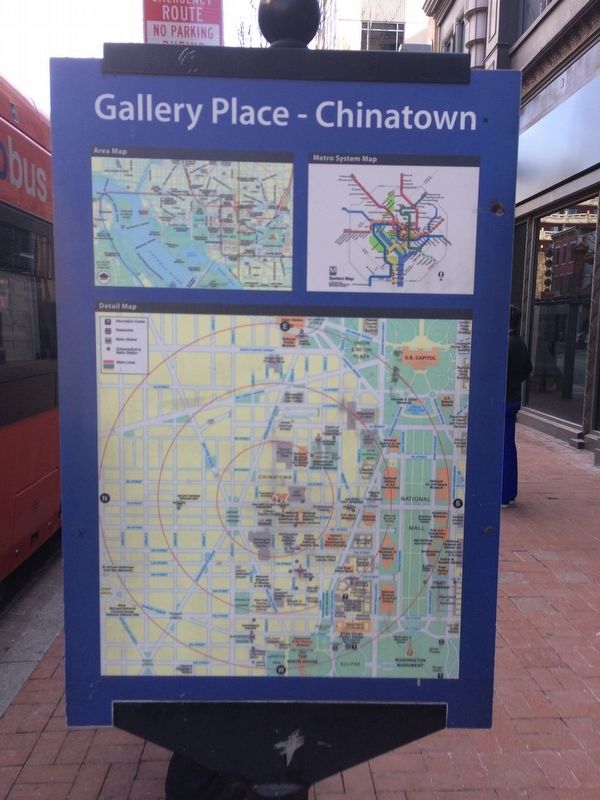
On F Street Northwest at 7th St Southwest, on the right when traveling west on F Street Northwest.
Welcome to downtown Washington, DC — an area rich in history, culture, and places to see. You will enjoy visiting the following sites located in the vicinity of this sign.
Chinatown Arch
Chinatown, centered on Seventh and H . . . — — Map (db m113226) HM
On F Street Northwest west of 12th Street Northwest, on the right when traveling east.
Welcome to downtown Washington, DC — an area rich in history, culture, and places to see. You will enjoy visiting the following sites in the vicinity of this sign.
[Clockwise from top left:]
Old Post Office Pavilion
The . . . — — Map (db m114658) HM
On Georgia Avenue Northwest (U.S. 29) at Rock Creek Church Road Northwest, on the right when traveling south on Georgia Avenue Northwest.
It’s the summer of 1862. Early morning, but already hot and dusty. You’re standing at this spot, when you see a tall man on horseback. It’s President Abraham Lincoln. You’re pleased to see him, but not surprised. After all, he rides by here . . . — — Map (db m130757) HM
On Martin Luther King Jr. Avenue Southeast at Good Hope Road Southeast, on the right when traveling north on Martin Luther King Jr. Avenue Southeast.
Late On The Night Of April 14, 1865, a guard at the other end of the Navy Yard Bridge allowed a young man on horseback to cross, despite a wartime curfew. Unbeknownst to the guard, the rider, John Wilkes Booth, had just shot President Abraham . . . — — Map (db m100715) HM
On M Street Southeast west of 11th Street Southeast, on the right when traveling east.
The body of John Wilkes Booth, assassin of President Abraham Lincoln, was brought to the Navy Yard for examination and identification aboard the USS Montauk. With the exception of Mary Surratt, the Lincoln conspirators (including Lewis Payne, . . . — — Map (db m126460) HM
On 3rd Avenue north of C Street, on the left when traveling north.
On April 14, 1865 John Wilkes Booth (of Maryland) assassinated President Abraham Lincoln at Fords Theater in downtown Washington. Booth's conspirators were arrested and tried by a Military Court here in Building 20 from May 9 to June 30, 1865. One . . . — — Map (db m29740) HM
Near South Beach Road, 0.8 miles south of Oceanic Drive. Reported permanently removed.
Divided loyalties and ironies tore at Marylander's hearts throughout the Civil War: enslaved African-Americans and free United States Colored Troops; spies and smugglers; civilians imprisoned without trial to protect freedom; neighbors and families . . . — — Map (db m72089) HM
Green Mount Cemetery was dedicated in 1839 on the site of the former country estate of Robert Oliver. This was the beginning of the “rural cemetery movement”; Green Mount was Baltimore’s first such rural cemetery and one of the first . . . — — Map (db m62629) HM
On 2nd Street at Gay Street, on the right when traveling north on 2nd Street. Reported permanently removed.
Divided loyalties and ironies tore at Marylanders’ hearts throughout the Civil War: enslaved African-Americans and free United States Colored Troops; spies and smugglers; civilians imprisoned without trial to protect freedom; neighbors and . . . — — Map (db m168144) HM
On Bel Alton Newtown Road at Fairground Road, on the left when traveling east on Bel Alton Newtown Road.
John Wilkes Booth and his accomplice Harold hid in a thick woods on Samuel Cox's farm. (One mile north →) for several days before escaping to Virginia after Lincoln's assassination April 14, 1865. — — Map (db m129023) HM
On Bel Alton Newton Road at Wills Road, on the right when traveling north on Bel Alton Newton Road.
John Wilkes Booth and David Herold remained hidden from April 16 to 21, 1865 in a nearby pine thicket, while Union troops searched for them. Thomas A. Jones brought them food and the newspapers. — — Map (db m39524) HM
On Bel Alton Newtown Road at Wills Road, on the right when traveling north on Bel Alton Newtown Road.
After assassinating President Abraham Lincoln on April 14, 1865, John Wilkes Booth and his accomplice, David A. Herold, fled Washington for Southern Maryland, a hotbed of Confederate sympathizers. After leaving the home of Dr. Samuel A. Mudd near . . . — — Map (db m39528) HM
On Bel Alton Newtown Road, on the left when traveling east.
Mid-18th century farm house (with alterations after 1800) was home of Col. Samuel Cox. This southern sympathizer fed and sheltered fugitives John Wilkes Booth and David E. Herold before dawn on Easter Sunday, April 16, 1865 following Booth's . . . — — Map (db m4458) HM
Near Bel Alton Newtown Road, 0.1 miles east of Rich Hill Farm Road, on the right when traveling west.
After leaving Dr. Samuel A. Mudd's house on April 15, 1865, John Wilkes Booth, the assassin of President Abraham Lincoln, and his accomplice David E. Herold avoided Zekiah Swamp and made a wide arc around the village of Bryantown. Unsure of their . . . — — Map (db m129036) HM
Near Rich Hill Farm Road, 0.1 miles north of Bel Alton Newtown Rd. Reported permanently removed.
(Right Banner)
After leaving Dr. Samuel A. Mudd's house on April 15, 1865, John Wilkes Booth, the assassin of President Abraham Lincoln, and his accomplice David E. Herold avoided Zekiah Swamp and made a wide arc around the village of . . . — — Map (db m129045) HM
Near Rich Hill Farm Road, 0.1 miles Bel Alton Newtown Rd.
)
1666
Hugh Thomas receives a 600 acre patent to "Rich Hill." )
1666—1714
Beginnings )
1714—1807
Brown Family Era )
(Image of Dr. Gustavus Brown) )
Scottish immigrant Dr. Gustavus Brown builds the house.
1729 . . . — — Map (db m129049) HM
On Olivers Shop Road (Maryland Route 232) 1.2 miles south of Leonardtown Road (Maryland Route 5).
On November 13, 1864, here at St. Mary’s Catholic
Church, Dr. Samuel A. Mudd was introduced to John
Wilkes Booth, the future assassin of President Abraham Lincoln. Booth had come to Charles County to
contact the Confederate underground here and . . . — — Map (db m924) HM
On Popes Creek Road, 1 mile south of Crain Highway (U.S. 301), on the right when traveling south.
Home of Confederate Mail Agent, Thomas A. Jones, who helped to shelter, and aided the escape of John Wilkes Booth and David Herold in their flight, April 16th to 21st 1865. — — Map (db m129119) HM
On Popes Creek Road, 3 miles south of Crain Highway (U.S. 301), on the left when traveling south.
After assassinating President Abraham Lincoln on April 14, 1865, John Wilkes Booth and his accomplice, David A. Herold, fled Washington for Southern Maryland, a hotbed of Confederate sympathizers. Concealed for several days in a pine thicket two . . . — — Map (db m128807) HM
On Popes Creek Road, 1.8 miles south of Crain Highway (U.S. 301).
John Wilkes Booth and David Herold set out from here for the Virginia shore during the night of April 21, 1865, in a boat supplied by Thomas A. Jones. — — Map (db m128809) HM
Near Crain Highway (U.S. 301) 0.7 miles south of Rock Point Road (Maryland Route 257). Reported permanently removed.
Divided loyalties and ironies tore at Marylander’s hearts throughout the Civil War: enslaved African-Americans and free United States Colored Troops; spies and smugglers; civilians imprisoned without trial to protect freedom; neighbors and . . . — — Map (db m24540) HM
Near Crain Highway (U.S. 301) south of Venus Road, on the right when traveling north.
Divided loyalties and ironies tore at Marylanders' hearts throughout the Civil War: enslaved African Americans and free United States Colored Troops; spies and smugglers; civilians imprisoned without trial to protect freedom; neighbors and . . . — — Map (db m186732) HM
Near Chapel Point Road, on the right when traveling east.
Divided loyalties and ironies tore at Marylander’s hearts throughout the Civil War: enslaved African-Americans and free United States Colored Troops; spies and smugglers; civilians imprisoned without trial to protect freedom; neighbors and families . . . — — Map (db m1104) HM
In this center of Confederate activity, at the Brawner Hotel, Detective Captain William Williams unsuccessfully offered Thomas Jones $100,000 reward for information that would lead to the capture of John Wilkes Booth. — — Map (db m128825) HM
Near Commerce Street west of Chapel Point Road when traveling west.
Port Tobacco was the home and place of business of George Atzerodt. Although he failed to murder Vice President Andrew Johnson, he was convicted and executed for his role in the plot to assassinate President Abraham Lincoln.
Part . . . — — Map (db m128954) HM
On Dr. Samuel Mudd Road (Maryland Route 232) near Poplar Hill Road (Maryland Route 382).
This house was the home of Dr. Samuel Alexander Mudd and his wife, Sarah Frances Dyer. Early on the morning of April 15, 1865, John Wilkes Booth arrived here with a companion, David E. Herold, and asked Mudd to set Booth’s broken leg. Afterward, as . . . — — Map (db m921) HM
On Dr. Samuel Mudd Road (Maryland Route 232) south of Poplar Hill Road (Maryland Route 382).
Divided loyalties and ironies tore at Marylanders’ hearts throughout the Civil War: enslaved African-Americans and free United States Colored Troops; spies and smugglers; civilians imprisoned without trial to protect freedom; neighbors and families . . . — — Map (db m922) HM
On Leonardtown Road (Maryland Route 5) near Mattawoman - Beantown Road (Maryland Route 5).
Dr. Mudd set the broken leg of Wilkes Booth who escaped from Washington after Lincoln's assassination on April 14, 1865. Dr. Mudd was tried and imprisoned on Dry Tortugas Island. — — Map (db m8932) HM
On Crain Highway (U.S. 301) at Cedarville Road, on the right when traveling south on Crain Highway.
John Wilkes Booth
and his companion David Herold
entered Charles County near this spot after assassinating President Abraham Lincoln in Washington on April 14, 1865. — — Map (db m24211) HM
On Brandywine Road (Maryland Route 381) 0.1 miles south of Woodyard Road (Maryland Route 223), on the left when traveling south.
The assassin of Lincoln stopped here at the house of Mrs. Surratt to secure ammunition on the night of April 14, 1865. He rode on to "T.B." and then to Dr. Mudd's who set his broken leg. — — Map (db m3612) HM
On Brandywine Road at Woolyard Road (Maryland Highway 223) on Brandywine Road.
Divided loyalties and ironies tore at Marylanders’ hearts throughout the Civil War: enslaved African-Americans and free United States Colored Troops; spies and smugglers; civilians imprisoned without trial to protect freedom; neighbors and families . . . — — Map (db m60164) HM
Near Brandywine Road (Maryland Route 381) 0.1 miles south of Woodyard Road (Maryland Road 223), on the left when traveling south. Reported permanently removed.
Owned and operated by the ardently pro-Southern Surratt family, this building was used by Confederate agents as a safe house during the Civil War. Built in 1852, the structure was a tavern, hostelry and post office.
Surratt's son, John, Jr., a . . . — — Map (db m4188) HM
On Brandywine Road, 0.1 miles north of Horseshoe Road, on the right when traveling north.
Owned and operated by the ardently pro-Southern Surratt family, this building was used by Confederate agents as a safe house during the Civil War. Built in 1852, the structure was a tavern, hostelry, and post office.
Surratt's son, John, . . . — — Map (db m154461) HM
Near Brandywine Road (Maryland Route 381) just north of Horseshoe Road, on the right when traveling north.
Built in 1852 for the family of John and Mary Surratt. Restored in 1975 in recognition of the buildings national historical significance relating to the assassination of President Abraham Lincoln. — — Map (db m141912) HM
Near Capital Beltway (Interstate 95) west of National Harbor Boulevard, on the right when traveling east.
After assassinating Abraham Lincoln, John Wilkes Booth fled on horseback to Prince George's County. He was aided by Mary Surratt and stopped at her tavern in Surrattsville (now known as Clinton). Though many today believe she was innocent, Mary . . . — — Map (db m127709) HM
On National Harbor Boulevard at Capital Beltway (Interstate 95), on the right when traveling south on National Harbor Boulevard.
1. Oxon Cove Farm & Oxon Hill Farm
Explore farm life and how it's changed over time by visiting the outbuildings and animal pens of a working farm, taking a wagon ride, and by participating in hands-on activities and living history . . . — — Map (db m202578) HM
On Point Lookout Road, on its terminus loop (Maryland Route 5), on the right when traveling north.
Divided loyalties and ironies tore at Marylanders’ hearts throughout the Civil War: enslaved African-Americans and free United States Colored Troops; spies and smugglers; civilians imprisoned without trial to protect freedom; neighbors and families . . . — — Map (db m1000) HM
Near Diagonal Road (Virginia Route 7) south of King Street (Virginia Route 7), on the right when traveling south. Reported permanently removed.
Welcome to Old Town Alexandria! Experience historical charm with contemporary flair from the river to the rails
Plan
Alexandria Visitors Center at Ramsay House
Knowledgeable staff help you create a perfect plan for your visit. . . . — — Map (db m115143) HM
Near Cameron Street east of North Union Street, on the right when traveling east. Reported permanently removed.
Welcome to Old Town Alexandria! Experience historical charm with contemporary flair from the river to the rails
Plan
Alexandria Visitors Center at Ramsay House
Knowledgeable staff help you create a perfect plan for your . . . — — Map (db m167097) HM
On North Main Street (State Highway 2) at Courthouse Lane (Local Route 1204), on the right when traveling north on North Main Street.
Built approximately 1820, the Star Hotel was one of two taverns serving Bowling Green. During the Civil War, it was operated by the Henry Gouldman family, and became a notorious Confederate spy headquarters and safe haven to those who aided Lincoln . . . — — Map (db m207706) HM
On AP Hill Boulevard (U.S. 301) 2.3 miles south of Tidewater Trail (U.S. 17), on the right when traveling north.
This is the site of Locust Hill, Richard Henry Garrett's farm. Early on the morning of 26 April 1865, a 16th New York Cavalry detachment cornered John Wilkes Booth, the assassin of President Abraham Lincoln, and his co-conspirator, David E. Herold, . . . — — Map (db m151255) HM
On U.S. 301, 2.5 miles south of U.S. 17, on the right when traveling north. Reported missing.
This is the Garrett place where John Wilkes Booth, assassin of Lincoln, was cornered by Union soldiers and killed, April 26, 1865. The house stood a short distance from this spot. — — Map (db m1584) HM
On King Street at Caroline Street, on the left when traveling north on King Street.
In front of you is the Brockenbrough-Peyton House where fugitives John Wilkes Booth and David Herold accompanied by three former Confederate soldiers arrived about 2:30 pm April 24, 1865, 10 days after Booth shot Lincoln. The owner, Randolph . . . — — Map (db m207405) HM
On AP Hill Boulevard (U.S. 301) at Tidewater Trail (U.S. 17), on the right when traveling south on AP Hill Boulevard.
On this road two miles south is the Garrett place. There John Wilkes Booth, Lincoln's assassin, was found by Union cavalry and killed while resisting arrest, April 26, 1865. — — Map (db m22246) HM
On Dahlgren Road (Virginia Route 206) at Cleydael Boulevard, on the right when traveling north on Dahlgren Road.
Dr. Richard H. Stuart built a T-shaped house just southeast of here in 1859 as a summer residence for his family. John Wilkes Booth and his accomplice David Herold, guided by a local farmer, arrived here on 23 April 1865 while attempting to escape . . . — — Map (db m138070) HM
On Dahlgren Road (Virginia Route 206) at Cleydael Boulevard, on the right when traveling north on Dahlgren Road. Reported permanently removed.
This T-shaped house was built in 1859 by Dr. Richard Stuart as a summer residence for his family. On Sunday afternoon, April 23, 1865, John Wilkes Booth and three companions came to this house seeking medical assistance from Dr. Stuart. Suspicious . . . — — Map (db m2925) HM
On US 301 James Madison Parkway, 0.5 miles south of VA 3 Kings Highway, on the right when traveling south.
The site of Port Conway is located five miles south on the Rappahannock River. Francis Conway laid out the town in 1783, and the next year the Virginia General Assembly passed an act establishing it. James Madison, Father of the Constitution and . . . — — Map (db m7290) HM
Near Skyline Drive south of Lee Highway (U.S. 211), on the right when traveling south.
During the Civil War, this gap in the Blue Ridge was of significant tactical importance for the movement of troops, artillery, and supply wagons. The Thornton’s Gap Turnpike, a macadamized (hard-surfaced) road, passed through the gap and linked . . . — — Map (db m100651) HM