First called Savage Diggins after the man who discovered gold here, 1848. Renamed Big Oak Flat about 1850 after giant oak tree that stood in the center of town, near this spot. Oak, which was about 13 feet in diameter and was undermined in 1869 and . . . — — Map (db m194153) HM
Reportedly founded about 1849 by group of Englishmen who employed Chinese as miners. Much surface gold found on hills and flats. Headquarters for stage lines in early 1850’s, and for several California Chinese mining companies. First Chinese tong . . . — — Map (db m906) HM
Near this site, now inundated by the waters of Don Pedro Reservoir, stood the historic town of Jacksonville. It was settled by Julian Smart who planted the first garden and orchard in the spring of 1849. Named for Colonel A. M. Jackson. In 1850 it . . . — — Map (db m5784) HM
Stopping place of packers carrying supplies to miners. Often 200 jackasses on hill over night furnishing concert suggesting name “Jackass Hill”. Very coarse gold found here. $10,000 taken from 100 square feet of ground. Quartz found containing 3/4 . . . — — Map (db m6861) HM
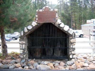
Replica, with original chimney and fireplace. Here on Jackass Hill, young Mark Twain, while guest of Gillis Brothers, 1864-65, gathered material for "Jumping Frog of Calaveras", which first brought him fame, and for "Roughing It". — — Map (db m53262) HM
Site of ferry crossing established 1860 by Thomas H. Parrott connecting mining towns of Tuttletown and Vallecito. Ferry in operation until 1903 when first bridge built. Ferry boat of flat bottom wooden construction propelled on heavy cables. Cable . . . — — Map (db m6839) HM
Name derived from two sawmills erected here to supply mining timbers early 1850’s. Population at one time 1000. Rich in pocket gold in heyday. Mining camp of Mexican woman, Doña Elisa Martinez, at north end of flat, reported to have been hideout . . . — — Map (db m149166) HM
Springfield received name from abundant springs gushing from limestone boulders. Town with its stores, shops and hotel, built around plaza. Once boasted 2,000 inhabitants. Believed founded by Donna Josefa Valmesada, Mexican woman of means with . . . — — Map (db m6810) HM
Early day stopping place for men and mounts. Named for Judge Anson A. H. Tuttle who built first log cabin here in 1848. Stones used in this base from old Swerer Store built in 1854, remains of which still exist, 1949. Mark Twain traded here. . . . — — Map (db m6843) HM
Formerly called “First Garrote” traced to hanging of Mexican for stealing horse. Adobe buildings still standing (1949) built in 1849 as shown by dated adobe brick taken from partition. Gold discovered here 1849. Thousands in placer gold taken from . . . — — Map (db m178693) HM
Sizable settlement established at this rich placer location in 1849 by miners spreading east from Big Oak Flat and Groveland. Famous Hangman's Tree, part of which still stands (1950), reported to have been instrumental in death of a number of . . . — — Map (db m163766) HM
Tuolumne County history begins here. Early in 1848 a party of Philadelphia prospectors under the leadership of James Woods discovered gold 500 feet south east of this marker, where the old road crosses the creek now bearing Woods’ name. James . . . — — Map (db m5782) HM
Settled by Julian Smart who planted first garden and orchard in Tuolumne County in spring of 1849. Named for Colonel A.M. Jackson who opened first trading post in 1849. In 1850 was second largest town in county and gathering center for thousands of . . . — — Map (db m53523) HM
“His heart was finer metal than any gold his shovel ever brought to light”. Gallant Mex. War veteran fought in principal battles. Came California, ’49, Jackass Hill, ’50. Built famous cabin, intimately associated there with Mark Twain . . . — — Map (db m53330) HM
In 1850 this community was alive with gold miners. James D. Fair, after whom the Fairmont Hotel in San Francisco is named, was one of the most notable. The Mississippi House, built in 1850, contains many relics including the original bar . . . — — Map (db m6811) HM
“Queen of the Southern Mines”, settled 1848 by Mexicans from Sonora, Mexico. City government established 1849. “Sonora Herald”, first newspaper in California mines, established July 4, 1950. Single copy, fifty cents; yearly, . . . — — Map (db m32021) HM
The first community in Tuolumne County to be founded (1855) entirely upon the operation of a lode mine. Site of the famous Soulsby Mine (discovered by Benjamine Soulsby) which produced over $6,500,00 by 1900. The first hardrock miners who worked . . . — — Map (db m6951) HM
Toll gate, fine hotel and stables near this spot 1850's. Jedediah Smith reputed to have been first white man to cross over or near Sonora Pass, 1827. Portion of road built by Tuolumne County Water Co., 1852. Surveyed to Bridgeport, Mono County, . . . — — Map (db m6884) HM
First placer camp in East Belt section of Mother Lode. Gold discovered here in 1853 by Scott brothers, descendants of Cherokee Indians. Scars of placer “diggings” in every little arroyo in Cherokee Valley healed over by Mother Nature . . . — — Map (db m6819) HM
Geographical center of East Belt Placer Gold Rush, 1856-57. First white settlers, the Franklin Summers family, arrived in 1854 and built log cabin half mile west. James Blakely, in 1858, discovered first quartz lode, half mile east, naming it . . . — — Map (db m6711) HM