111 entries match your criteria. The first 100 are listed. The final 11 ⊳
The Washington-Rochambeau Route Historical Markers
In 1781 the two Generals met in White Plains, New York, crossed the Hudson River and marched 450 miles south to Yorktown in Virginia where their and Lafayette’s armies defeated the British, ending the war.
On Main Street, 0.1 miles north of South Street, on the right when traveling north.
French General Jean Baptiste Donatien de Vimeur, comte de Rochambeau, and thousands of French ground and naval forces arrived in Newport in July of 1780 to assist the Americans in the War for Independence. After wintering in Newport, Rochambeau’s . . . — — Map (db m243483) HM
On Monroe Turnpike (Route 111) at Moose Hill Road, on the right when traveling north on Monroe Turnpike.
The
Rochambeau
Route
1781 – 82
In the Vicinity
French Troops Under
Duc De Lauzun
Enroute From Newport
To Yorktown
Encamped During
June 29 Through
July 1st 1781
Erected by The
Sons of the American Revolution
Gen. Gold . . . — — Map (db m190233) HM
On Church Hill Road (U.S. 6) at Queen Street, on the right when traveling east on Church Hill Road.
1732 ---- 1932
In Commemoration Of
The Two Hundredth Birthday Of
George Washington
----
Rochambeau
Established a Camp Here
June 28 To July 1, 1781
----
Soldiers Commanded By
Lafayette
Camped At This Spot
Placed by Mary . . . — — Map (db m26914) HM
On Church Hill Road (U.S. 6) at Queen Street, on the right when traveling west on Church Hill Road.
French General Jean Baptiste Donatien de Vimeur, comte de Rochambeau, and thousands of French ground and naval forces arrived in Newport in July of 1780 to assist the Americans in the War for Independence. After wintering in Newport, Rochambeau’s . . . — — Map (db m26915) HM
On Ridgebury Road at George Washington Hwy., on the right when traveling south on Ridgebury Road.
Gathered Built 1760 1851 This property is listed in the National Register of Historic Places by the United States Department of the Interior < Second Plaque: > Connecticut Washington – Rochambeau Revolutionary . . . — — Map (db m23423) HM
On Ridgebury Road at Old Stagecoach Road, on the left when traveling south on Ridgebury Road.
French General Jean-Baptiste Donatien de Vimeur, Comte de Rochambeau, and thousands of French ground and naval forces arrived in Newport in July of 1780 to assist the Americans in the War for Independence. After wintering in Newport, Rochambeau’s . . . — — Map (db m23416) HM
On Farmington Avenue (Connecticut Route 4) at Main Street (Connecticut Route 10), on the left when traveling east on Farmington Avenue.
Lest We Forget
In honor and grateful remembrance of our French Allies in the Revolution, whose army, under the command of General Count de Rochambeau, marched past this spot enroute from Newport and Providence, R.I., to join General Washington on . . . — — Map (db m190186) HM
On Main Street at Gold Street, on the right when traveling north on Main Street.
George Washington
was entertained by
Colonel Jeremiah Wadsworth in his home on this site on June 30, 1775 when on his way to Cambridge to assume command of the Army.
On September 21, 22, 23, 1780 with Lafayette, General Knox and Governor . . . — — Map (db m151930) HM
Near Main Street at Central Row, on the right when traveling north.
This tablet commemorates the historic first meeting of General George Washington and General Comte de Rochambeau, commander-in-chief of the French army in America, which took place September 20, 1780.
On that occasion and in a subsequent meeting . . . — — Map (db m52914) HM
On Tower Square just west of Prospect Street, on the right when traveling west.
Jeremiah Wadsworth was Commissary-General in the Continental Army. His house which stood at the present site of the Wadsworth Atheneum was the meeting place for many leaders of the American Revolution, among them Washington, Lafayette, and . . . — — Map (db m151929) HM
On American Row at Main Street, on the right when traveling west on American Row.
Washington – Rochambeau Revolutionary Route
Hartford
French General Jean Baptiste Donatien de Vimeur, comte de Rochambeau, and thousands of French ground and naval forces arrived in Newport in July of 1780 to assist the Americans . . . — — Map (db m43739) HM
On Main Street (Connecticut Route 10) at Grove Street, on the left when traveling north on Main Street.
Southington
French General Jean Baptiste Donatien de Vimeur, comte de Rochambeau, and thousands of French ground and naval forces arrived in Newport in July of 1780 to assist the Americans in the War for Independence. After wintering in . . . — — Map (db m165804) HM
On Marion Avenue at Burritt Street, on the right when traveling north on Marion Avenue.
Rochambeau
Lieut. General
Commanding
The Auxiliary French Armies
Under
Washington
July 10, 1780 Jan 11, 1783
Rochambeau's letter to Congress
"We are your brothers. We shall
conduct ourselves as such with you.
We shall fight . . . — — Map (db m33706) HM
On Main Street near Marsh Street, on the right when traveling north.
Washington – Rochambeau Revolutionary Route
Wethersfield
French General Jean Baptiste Donatien de Vimeur, comte de Rochambeau, and thousands of French ground and naval forces arrived in Newport in July of 1780 to assist the . . . — — Map (db m46299) HM
On Middlebury Road (Connecticut Route 64) 0.1 miles west of Charcoal Avenue, on the right when traveling east.
In this vicinity
French Troops under
Rochambeau
enroute to Yorktown
encamped during June 1781
Erected by the state
and
Mattatuck Branch,
Sons Amer. Rev.
Cooperating — — Map (db m19690) HM
Near East Main Street, on the left when traveling west.
This memorial was erected by Patriotic Citizens and Statesmen to commemorate two French Soldiers of Rochambeau's Army who volunteered to fight for American Independence under Washington, enroute from Newport to Yorktown, died and were buried here, . . . — — Map (db m36024) HM
On West Main Street at Church Street, on the right when traveling east on West Main Street.
Washington – Rochambeau Revolutionary Route
Waterbury, Middlebury, Southbury
French General Jean Baptiste Donatien de Vimeur, comte de Rochambeau, and thousands of French ground and naval forces arrived in Newport in July of 1780 to . . . — — Map (db m190232) HM
On West Town Street at Exeter Road (Connecticut Route 207), on the left when traveling north on West Town Street.
Winter Encampment in Lebanon
French General Jean Baptiste Donatien de Vimeur, comte de Rochambeau, and thousands of French ground and naval forces arrived in Newport in July of 1780 to assist the Americans in the War for Independence. After . . . — — Map (db m242004) WM
On Bolton Center Road, 0.1 miles east of Bayberry Road, on the left when traveling east.
In this Vicinity
French Troops Under
Rochambeau
Enroute to Yorktown
Encamped During June 1781
Erected by the State
and
Oxford Parish
Chapter D.A.R.
Cooperating — — Map (db m142365) HM WM
On Bolton Center Rd at Hebron Rd, on the right when traveling east on Bolton Center Rd.
Bolton
French General Jean Baptiste Donatien de Vimeur, comte de Rochambeau, and thousands of French ground and naval forces Arrived in Newport in July of 1780 to assist the Americans in the War for Independence. After wintering in Newport, . . . — — Map (db m190090) HM WM
On Huntington Road (Connecticut Route 14) at Pinch Street, on the left when traveling east on Huntington Road.
Eastern Connecticut
French General Jean Baptiste Donatien de Vimeur, comte de Rochambeau, and thousands of French ground and naval forces arrived in Newport in July of 1780 to assist the Americans in the War for Independence. After wintering in . . . — — Map (db m190106) HM
On Plainfield Pike (Route 14A) at Sterling Hill Road, on the left when traveling east on Plainfield Pike.
In this Vicinity
French Troops Under
Rochambeau
Enroute from Yorktown
Encamped During November 1782
Erected by the State and
Deborah Avery Putnam
Chap. D.A.R.
Cooperating — — Map (db m140728) HM WM
On Scotland Road (Connecticut Route 14) east of Mullen Hill Road, on the right when traveling west.
In This Vicinity
French Troops Under
Rochambeau
Enroute From Yorktown
Encamped During November 1782
Erected by the State
and
Windham Library
Association
Cooperating — — Map (db m216461) HM WM
A Victorious Allied Army Passed Here
1781 was a momentous year for the United States. A French Army, led by General Rochambeau, had arrived in Rhode Island in July 1780. By June 1781, it was ready to join the U.S. Continental Army against . . . — — Map (db m189558) HM
On Sunset Lake Road (Delaware Route 72) north of Dayett Mill Road, on the left when traveling north. Reported permanently removed.
During the American Revolution Lauzun's Legion
spent the winter and spring of 1782-1783 in Wilmington to help guard Philadelphia and Baltimore from British attack. The troops were housed in the Wilmington Academy, located where the Grand Opera . . . — — Map (db m209340) HM
On September 4-7, 1781, residents of Brandywine Village watched as thousands of American and French troops marched through their community along the King’s Highway on their way to Yorktown, Virginia. The combined forces, under the commands of . . . — — Map (db m140593) HM WM
On North Market Street south of East 9th Street, on the left when traveling south.
During the American Revolution Lauzun's Legion spent the winter and spring of 1782-1783 in Wilmington to help guard Philadelphia and Baltimore from British attack. The troops were housed in the Wilmington Academy, located where the Grand Opera . . . — — Map (db m166673) HM
On Pennsylvania Avenue Northwest at Jackson Place Northwest, on the right when traveling west on Pennsylvania Avenue Northwest.
[front, south face:]
Rochambeau
[back, north face:]
"We have been contemporaries and fellow labourers in the cause of liberty, and we have lived together as brothers should do, in harmonious friendship," . . . — — Map (db m32973) HM
On 6th Street, 0.1 miles north of Severn Avenue, on the right when traveling north.
On February 20, 1781, George Washington ordered the Marquis de Lafayette with 1,200 men of the newly-established Light Infantry Corps to Virginia to counter Benedict Arnold's raids around Richmond. Lafayette arrived at the Head of Elk on March 3 . . . — — Map (db m170197) HM
On Crownsville Road (Maryland Route 178) 1.1 miles south of Crownsville Road, on the left when traveling south.
French troops under Count de Rochambeau made their 36th camp here September 16-17, 1781, enroute to Yorktown, Virginia. Most of the troops embarked from Annapolis, but the artillary marched to Georgetown to cross the Potomac River. — — Map (db m2928) HM
On Generals Highway (Maryland Route 178) 0.3 miles south of Sunrise Beach Road, on the right when traveling south.
Count de Rochambeau’s troops marched over this road from Spurrier’s Tavern to “Scott’s Plantation” (Belvoir) on Sept. 16, 1781 on the way to Yorktown. Washington and Rochambeau had gone ahead Sept. 10–11 on the way to Mt. Vernon. — — Map (db m2890) HM
On North Charles Street at East Mulberry Street, on the left when traveling north on North Charles Street.
This elm has watched the growth of "Baltimore Towne" for over 100 years, on former estate of John Eager Howard, Revolutionary and 1812 Officer and fifth governor of Maryland. Here, in "Howard's Woods", Count De Rochambeau's troops camped, 1782, . . . — — Map (db m209470) HM
On East Baltimore Street, on the right when traveling west.
Coming from their camp at White Marsh in the early afternoon of Wednesday, 12 September 1781, the First Brigade of French forces, consisting of the infantry regiments Bourbonnais and Royal Deux-Ponts marched into Baltimore on Pulaski Highway [US . . . — — Map (db m166667) HM
Our nation never had more at risk than it did in September 1781. The American Revolutionary War—the War for independence—had raged for nearly six years.
More than 4,000 American and French troops, allied in their fight against the . . . — — Map (db m166497) HM
Near West Camden Street just west of Howard Street.
Our nation never had more at risk than it did in September 1781. The American Revolutionary War—the War for Independence—had raged for nearly six years.
More than 4,000 American and French troops, allied in their fight against the . . . — — Map (db m166496) HM
On Ebenezer Road, 0.2 miles west of Pulaski Highway (U.S. 40), on the right.
Rochambeau’s Troops camped here September 11, 1781 where the baggage train and heavy artillery rejoined them. After the victory at Yorktown the French Troops, in five divisions, camped here again on their way northward, at the end of August 1782. — — Map (db m2135) HM
On Rock Springs Road (U.S. 222) at Old Conowingo Road, on the left when traveling north on Rock Springs Road.
Near Pilot, two and one-half miles northwest of this point, lies the site of a Susquehanna fording used by Indians before the coming of the white man. By 1695, a barge provided ferry service to the colonists. The Conowingo Lake now covers the . . . — — Map (db m127912) HM
On West Main Street at North Street (Maryland Route 268), on the left when traveling east on West Main Street.
Lafayette
embarked his troops March 8, 1781 to capture Benedict Arnold. Returned April 9, began overland march to Virginia April 12, 1781.
Washington and Rochambeau
with their combined forces stopped Sept. 6-7, 1781 on way to . . . — — Map (db m154172) HM
On Main Street, 0.2 miles west of River Road, on the left when traveling west.
Crossed the Susquehanna River in five divisions and made their 23rd camp here at the end of August 1782 on the return from Yorktown victory to the north. — — Map (db m145428) HM
On Jacob Tome Memorial Highway (Maryland Route 276) at Dr. Jack Road, on the right when traveling south on Jacob Tome Memorial Highway.
Count de Rochambeau’s heavy artillery and baggage train camped here September 9, 1781 before fording the Susquehanna at Bald Friar and proceeding to join the main army on the Philadelphia Road. — — Map (db m145653) HM
Upon arrival of French forces in Newport, Rhode Island in July 1780, Baron Ludwig von Closen, a captain in the Royal Deux-Ponts Regiment, was selected by General Rochambeau as one of his aides-de-camp. Closen accompanied Rochambeau on most of his . . . — — Map (db m62756) HM
On Philadelphia Road (Maryland Route 7) 0.8 miles south of Maryland Route 136, on the right when traveling south.
The French Troops of
Count de Rochambeau
in five divisions camped here at the end of August 1782—the 22nd camp on the return march from the Yorktown victory to the north. — — Map (db m1248) HM
On Churchville Road (Maryland Route 22) at Maryland Route 136, on the right when traveling west on Churchville Road.
Council of Safety met here 5 April 1775. Considered as site for county seat 1781
George Washington
passed 6 May 1775 on way to be made Commander-in-Chief of Army
Lafayette
and his troops marched past 15 April 1781 on the way to . . . — — Map (db m1243) HM
On Priestford Road (Route 136) south of Trappe Road, on the left when traveling north.
Count de Rochambeau’s heavy artillery and baggage train camped near this point September 10, 1781. After fording the Susquehanna River at Bald Friar they proceeded to Bush to join the main troops. — — Map (db m1283) HM
On Lewis Lane, 0.1 miles Old Post Road (Maryland Route 7), on the right when traveling north.
Count Rochambeau’s troops camped here September 9, 1781 after having crossed the Susquehanna River on their way to the siege of Yorktown, VA. — — Map (db m146941) HM
On Washington Street at St. John’s Street, on the right when traveling north on Washington Street.
Named for the French General whose troops passed through here in 1781 en route to Yorktown. Records of the French Army noted plans were underway for a town at this place when the troops returned from Yorktown in 1782. — — Map (db m1274) HM
On Old Baltimore Pike at Odell Road on Old Baltimore Pike.
An important stopping place in colonial days. Mentioned by Washington, Lafayette and other noted men after the Revolution. Count de Rochambeau's troops camped here in June 1782 on the return march from the victory at Yorktown. — — Map (db m3574) HM
On Ramapo Valley Road (U.S. 202) at Breakshoe Place, on the right when traveling south on Ramapo Valley Road.
On August 25, 1781 during the historic 600-mile march to what was the Revolutionary War’s decisive Battle of Yorktown, Gen. Rochambeau’s army was forced to ford this river because the bridge that was here was in poor shape. The bridge of . . . — — Map (db m165837) HM
On Stockton Street, on the left when traveling south.
On this site, the allied American and French troops of Generals Washington and Le Comte de Rochambeau encamped August 29 to September 1, 1781 enroute to their Victory at Yorktown American independence was assured there in Virginia by the defeat . . . — — Map (db m64117) HM
Historically, Lamberton was the loose-knit fishing village and port that extended along the left bank of the Delaware River from Ferry Street to Riverview Cemetery. The heart of the community lay between Landing and Lalor Streets, exactly where the . . . — — Map (db m165803) HM
Two ferries across the Delaware River in the Trenton area date from the late 17th century – the Yardley Ferry and the Trenton or Middle Ferry. Two more – the Upper and Lower Ferries – were added later in the 18th century. The Yardley Ferry, four . . . — — Map (db m166091) HM
On Whippany Road, on the right when traveling north.
“ . . . Whippany will be a good place for a halt . . . ” Washington to Rochambeau On August 27 and 28, 1781, a 5,000-man French Army under General Count Rochambeau encamped on grounds extending northeast from here toward the . . . — — Map (db m36418) HM
On Newark Pompton Turnpike at Dogwood Lane, on the left when traveling north on Newark Pompton Turnpike.
King Louis XVI’s French Army under the command of General Count de Rochambeau camped here on the Mandeville Farm in August 1781.
The troops were marching from Rhode Island to join General Washington and the Continental Army prior to the . . . — — Map (db m165914) HM
On Main Street (U.S. 202) at Heritage Ct., on the left when traveling north on Main Street.
Circa 1760 Dutch Stone House where George Washington and Alexander Hamilton stayed June 25-27, 1780, following the Battle of Springfield. French forces under Gen. Rochambeau rested in the orchard August 27, 1781, en route to Yorktown.
. . . — — Map (db m165838) HM
On Griggstown Causeway just east of Millstone River Road, on the left when traveling west.
Route of Continental Army of Morristown after Battle of Princeton, Jan. 3, 1777. Route also of armies marching from New York to Yorktown, VA. Aug. 30-31, 1781. — — Map (db m16700) HM
On Valley Road just south of Church Street, on the right when traveling south.
On this site French Troops under Le Comte De Rochambeau encamped August 29, 1781 en route to meeting Gen. George Washington and achieving their victory at Yorktown, American independence was assured there in Virginia by the defeat and surrender of . . . — — Map (db m11580) HM
On U.S. 9 at Interstate 84, on the right when traveling north on U.S. 9.
During the Revolutionary War, the Van Wyck Homestead served as headquarters for the Fishkill Supply Depot, a supply center for Washington’s Continental Army. At this bustling “city” of industry, hammers clanged, and smoke rose from many workshops. . . . — — Map (db m190331) HM
On U.S. 9 at Interstate 84, on the right when traveling north on U.S. 9.
In 1781, the American and French allies combined their armies at a pivotal turning point in the Revolutionary War. Under the command of General George Washington and French General Jean-Baptiste Donatien de Vimeur, comte de Rochambeau, the armies . . . — — Map (db m190176) HM
Near Main Street at Aylward Way, on the right when traveling north.
In 1781, the American and French allies combined their armies
at a pivotal turning point in the Revolutionary War. Under the
command of General George Washington and French General
Jean-Baptiste Donatien de Vimeur, comte de Rochambeau,
the . . . — — Map (db m202840) HM WM
Washington-Rochambeau Revolutionary Route National Historic Trail
During the American Revolution, King’s Ferry was the most secure Hudson River crossing north of British-held New York City. It was the key connecting New England with the rest . . . — — Map (db m165722) HM
Washington-Rochambeau Revolutionary Route National Historic Trail
In 1781, the American and French allies combined their armies at a pivotal turning point in the Revolutionary War. Under the command of General George Washington and French . . . — — Map (db m165738) HM
On Washington Avenue at Lafayette Avenue, on the left when traveling north on Washington Avenue.
After crossing the Hudson, Commander-in-chief of the French army in America, General Jean-Baptiste Rochambeau, encamped here with his 5000 troops en route from Newport, R.I. to Virginia. Joining with Gen. Washington, the two armies hurried to . . . — — Map (db m189603) HM
On Hardie Street at Broadway, on the left when traveling north on Hardie Street.
Dedicated to the soldiers of the Continental and French armies who crossed the Hudson River here at King’s Ferry August 20-26, 1781 on their march to Victory at Yorktown, Va. May their sacrifices and hardships never be forgotten, the Liberty and . . . — — Map (db m166067) HM
On Hardie Street at Broadway, on the right when traveling south on Hardie Street.
“You will be pleased on the receipt of this, to order One hundred and fifty Men to bring thirty of the aforesaid Boats to Kings Ferry . . . ” Washington to Alexander McDougall, August 18, 1781 In August 1781, the . . . — — Map (db m101118) HM
On Hardie Street at Broadway, on the right when traveling south on Hardie Street.
In 1781, the American and French allies combined their armies at a pivotal turning point in the Revolutionary War. Under the command of General George Washington and French General Jean-Baptiste Donatien de Vimeur, comte de Rochambeau, the armies . . . — — Map (db m101116) HM
On Baldwin Road at Lavoie Court, on the left when traveling south on Baldwin Road.
French Hill - The Road to Victory During the American Revolution
Background:
During the American Revolution, the Americans needed the help of the French to secure their hopes of independence. In 1778, thanks to the efforts of Ben . . . — — Map (db m190271) HM
Mary Ferrazzoli (1928-1994) was the visionary leader who founded the Friends of the Waterfront in 1982. She vigorously championed public access and stood firmly opposed to the commercial overdevelopment of the Newport waterfront blocking public . . . — — Map (db m189622) HM
On Wellington Avenue, on the right when traveling west.
[ Left Marker : ]On June eighteenth, 1781, General Rochambeau left Newport with his army to join the American forces on the Hudson, and on August nineteenth, 1781, the combined armies under command of General Washington began their . . . — — Map (db m48054) HM
On Main Street (U.S. 44) at Hopkins Street, on the right when traveling south on Main Street.
A turning point in the American Revolution came in February 1780, when the King of France approved a plan to send an army to help the Americans. A French fleet carrying thousands of soldiers arrived five months later in Newport, where they spent . . . — — Map (db m189624) HM
On Oronoco Street at North Washington Street (Virginia Route 400), on the left when traveling east on Oronoco Street.
Most of the American and French armies set sail from three ports in Maryland—Annapolis, Baltimore, and Head of Elk—in mid-Sept. 1781 to besiege the British army in Yorktown. The allied supply-wagon traln proceeded overland to Yorktown, . . . — — Map (db m8570) HM
On Richmond Highway (U.S. 1) at Furnace Road (County Route 611), on the right when traveling north on Richmond Highway.
Colchester, founded in 1753 at the location of a ferry crossing, was the second town established in Fairfax County. Located on the main post road from Boston to Charleston, and at the end of the Ox Road leading west to the Blue Ridge, the town . . . — — Map (db m206) HM
On Gunston Road (Virginia Route 242) 0.2 miles south of Old Colchester Road (Virginia Route 611), on the right when traveling south.
Elizabeth Hartwell Mason Neck National Wildlife Refuge
…A serene place, where young blue herons learn to fish in the marshes, and wood thrushes trill their flute-like song through the stillness of hardwood forests. A place . . . — — Map (db m197456) HM
On Old Colchester Road (Virginia Route 611) north of Greene Drive, on the right when traveling south.
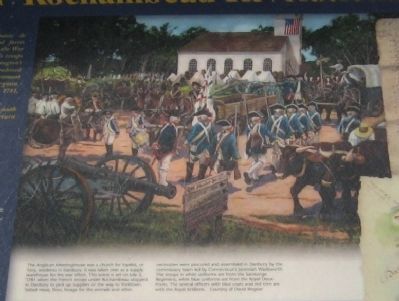
Some of the features shown here that were prominent on Mason Neck in Fairfax County during the marches of the Armies of the American War of Independence, exist today through generations of historic preservation efforts. The rich natural . . . — — Map (db m198378) HM
On Old Colchester Road (Virginia Route 611) north of Greene Drive, on the right when traveling south.
It was no picnic
A bivouac for the allied armies was not simply a bed to rest for the night, but a place with a daily set of demanding chores. Hundreds of oxen and horses needed to be unhitched, fed, watered, and secured for the night, . . . — — Map (db m198377) HM
On Old Colchester Road (Virginia Route 611) north of Greene Drive, on the right when traveling south.
Late in the American War for Independence, allied generals George Washington and the Comte de Rochambeau received good news. A French fleet under Admiral de Grasse carrying 3,000 French soldiers was headed for the Chesapeake Bay. Following the . . . — — Map (db m243223) HM
On Old Colchester Road (Virginia Route 611) north of Greene Drive, on the right when traveling south.
Colchester is the colonial tobacco port town on Mason's neck that witnessed the passage of the allied French and American armies on their way to and from Yorktown, Virginia in 1781 and 1782. The town provided a route to an Occoquan River ford for . . . — — Map (db m198373) HM
On Mount Vernon Memorial Highway, 0.1 miles west of Mount Vernon Highway (Virginia Route 235), on the right when traveling west.
On August 14, 1781, Generals Washington and Rochambeau received news that a large French fleet under the command of Admiral de Grasse was headed for the Chesapeake Bay carrying 3,000 French soldiers. There the British general, Cornwallis, was . . . — — Map (db m902) HM
On Mount Vernon Memorial Highway, 0.1 miles west of Mount Vernon Highway, on the right when traveling west.
General Washington, in 1781, rode 60 miles in one day from Baltimore to Mount Vernon, which he had not visited for over 6 years. General Rochambeau arrived next day with his and Washington’s staff. They spent Sept. 10 and 11 at Mount Vernon before . . . — — Map (db m883) HM
On Hanover Courthouse Road (U.S. 301) 0.2 miles north of Depot Road, on the right when traveling north. Reported permanently removed.
General Washington and General Rochambeau passed here on Sept. 13, 1781 on their way to victory at Yorktown. One mile south, they turned east on state route 605.
The marking of this route is a gift from the French Government. Committee of the . . . — — Map (db m226210) HM
On Forge Road at Richmond Road (U.S. 60), on the right when traveling east on Forge Road.
First called John Lewis's Ordinary and then Fox's, Burnt Ordinary received its name in Jan. 1780 when, according to the Virginia Gazette, Fox's Ordinary burned to the ground. Later, in Oct. 1781, when the French army's wagon train passed by, . . . — — Map (db m16846) HM
On Pocahontas Trail (Virginia Route 60), on the right when traveling west.
At Trebell's Landing on the James River a mile southwest of here, the artillery and stores of the American and French Armies were located in September 1781. They were then conveyed overland some six miles to the siege lines at Yorktown. The troops . . . — — Map (db m9501) HM
Near New Kent Highway at Courthouse Circle. Reported permanently removed.
Lord Cornwallis's army was here, moving eastward, June 22, 1781; Lafayette, in pursuit, June 25; Washington, Rochambeau and Chastellux, on their way to Yorktown, September 14, 1781. A part of Joseph E. Johnston's army, retiring to Richmond, passed . . . — — Map (db m17738) HM
On Fortuna Center Plaza near Dumfries Road (Virginia Route 234), on the right when traveling north.
The Potomac Path, or King’s Highway, was a major transportation route linking the northern and southern colonies in colonial America. Following an ancient Indian trail, the road assumed great importance for overland travel between the colonies and . . . — — Map (db m5365) HM
On Frayley Boulevard (U.S. 1) north of Williamstown Drive, on the right when traveling north.
The roads through Prince William County were important routes for the Revolutionary War campaign of 1781. In April, the Marquis de Lafayette passed through the county on the King's Highway with a portion of Gen. George Washington's Continental Army. . . . — — Map (db m166461) HM
On Wolf Run Shoals Road north of Observer Lane, on the right.
In September 1781, General George Washington directed the repair and clearing of roads leading to and from Wolf Run Shoals, the main ford of the Occoquan River, located seven miles upstream from the main ferry at Colchester. Prince William and . . . — — Map (db m233892) HM
In the late 18th century, armies made the most use of the King’s Highway. Merchants preferred to move goods such as tobacco over the Potomac River since land travel was difficult. The road became a main transportation route after the . . . — — Map (db m4890) HM
In the late 18th century, armies made the most use of the King’s Highway. Merchants preferred to move goods such as tobacco over the Potomac River since land travel was difficult. The road became a main transportation route after the Revolutionary . . . — — Map (db m92678) HM
The King’s Highway was the first north-south route through Virginia. The road began in Boston and ended in Williamsburg. It may have followed one or more trails that American Indians used before European colonization.
The route was first . . . — — Map (db m4891) HM
On Telegraph Road, 0.3 miles east of Park Entrance Road, on the right when traveling west.
Follow the green blazes as this easy 0.5-mile loop trail takes you to a portion of a historic north-south route used by American Indians and early settlers. Revolutionary War troops commanded by George Washington and the Comte de Rochambeau traveled . . . — — Map (db m168434) HM
On Jefferson Davis Highway (U.S. 1) 0.1 miles south of Dale Blvd and Rippon Blvd, on the right when traveling south.
To the east is the only preserved segment of the Potomac Path, the earliest north-south route in northern Virginia. Following an ancient Indian trail, the road, later known as the King's Highway, assumed great importance for overland travel between . . . — — Map (db m2164) HM
111 entries matched your criteria. The first 100 are listed above. The final 11 ⊳