2194 entries match your criteria. The first 100 are listed. Next 100 ⊳
Pennsylvania Historical and Museum Commission Historical Markers
The official history agency of the Commonwealth of Pennsylvania administers a program of historical markers to capture the stories of people, places, events, and innovations that have affected the lives of Pennsylvanians over the centuries.
By Devry Becker Jones (CC0), February 19, 2022
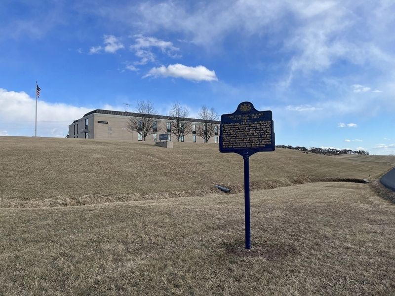
Penn State Fruit Research and Extension Center Marker
On South University Drive, 0.4 miles north of West York Street (Pennsylvania Route 234), on the right when traveling north.
Founded in 1918, FREC was established in response to management challenges faced by Pennsylvania fruit growers. Originally located in Arendtsville, the center moved here in 1971. Groundbreaking research has been conducted at . . . — — Map (db m192372) HM
On Chambersburg Road (U.S. 30), on the right when traveling east.
Surveyed in 1766. Named for an estate in England. The Manor was about 6 miles wide and 12 miles long with the southern boundary at present Mason-Dixon Line. It was the second largest reserved estate of the Penns in Pennsylvania. The western boundary . . . — — Map (db m11623) HM
On Chambersburg Road (U.S. 30), on the right when traveling west.
Crossing South Mountain from Chambersburg, Gen. Hill's Corps of Lee's army assembled here on June 29-30, 1863. On July 1, his advance guard moved up from near Marsh Creek and met Union Troops west of Gettysburg. — — Map (db m5814) HM
On Lincoln Highway (U.S. 30) at Buchanan Valley Road (State Route 234), on the right when traveling east on Lincoln Highway.
In 1758, during the French & Indian War, a party of French soldiers and Shawnee took Mary Jemison from her home 3 miles north of here. Although most of her family and neighbors were killed, Mary was adopted by two Seneca women. Jemison lived with . . . — — Map (db m11620) HM
On West King Street (State Highway 234) at 2nd Street, on the right when traveling east on West King Street.
Built ca. 1790 by David Studebaker, carpenter, farmer, and minister. He was related to the family that later built wagons and automobiles. The house is privately maintained as a museum. — — Map (db m11638) HM
On Catoctin Mountain Highway (U.S. 15), on the right when traveling north.
Founded 1681 by William Penn as a Quaker Commonwealth. birthplace of The Declaration of Independence and The Constitution of The United States — — Map (db m8055) HM
On Main Street (State Highway 116), on the right when traveling south.
Wounded of the Sixth U.S. Cavalry and Sixth Virginia Cavalry C.S.A. were cared for in this church building after a severe engagement that took place two miles north of here on July 3, 1863. — — Map (db m10773) HM
On Fairfield Road (State Highway 116) at Iron Springs Road (County Route 3014), on the right when traveling south on Fairfield Road.
Begun in 1836 by the State of Pennsylvania, largely through the efforts of Thaddeus Stevens. The meandering railroad's nickname was provided by its opponents. It was put up for sale in 1842. Just west of here stands its granite stone viaduct. — — Map (db m10767) HM
On West Middle Street at Baltimore Street (Business U.S. 15), on the right when traveling east on West Middle Street.
Formed January 22, 1800 out of York County. The name honors President John Adams. Important center of fruit growing industry. County seat of Gettysburg, incorporated 1806, was site in 1863 of key Civil War battle and President Abraham Lincoln's . . . — — Map (db m19252) HM
On Hillcrest Place, 0.1 miles south of Locust Avenue when traveling south.
This hallowed ground witnessed a furious struggle in a climactic moment on July 2, 1863, during the Battle of Gettysburg. Confederate forces attacked and briefly broke the Union line here. After a fierce struggle, the Confederates were forced to . . . — — Map (db m105076) HM
On North Washington Street, 0.1 miles south of West Stevens Street.
Born a free African-American. He taught the Colored people at this college, 1837, while a student at the Lutheran Seminary. A historian, he was elected bishop of the A.M.E. Church, 1852, and was president of Wilberforce University, 1863-76. — — Map (db m40951) HM
On Steinwehr Avenue (Business U.S. 15), on the right when traveling south.
Built in 1776 by the Rev. Alexander Dobbin. In use for some 25 years as one of the first classical schools west of the Susquehanna River. It is now a museum refurnished in keeping with the early period. — — Map (db m122380) HM
On North Washington Street (U.S. 15) at West Water Street, on the right when traveling north on North Washington Street.
The future President of the U.S., General of the Army, and Supreme Commander in Europe in WW II lived in this house with his wife Mamie and infant son Icky in the spring and summer of 1918. An Army captain, he was then commanding Camp Colt at . . . — — Map (db m6179) HM
On Carlisle Street (State Highway 34) at Lincoln Avenue (Business U.S. 15), on the right when traveling south on Carlisle Street.
Baseball great. One of the most dominant pitchers of the twentieth century. "Gettysburg Eddie" compiled a record of 326-194 throughout his career (1901-17), mostly with the Philadelphia Athletics. He won 20 Games or more eight times and helped the . . . — — Map (db m8651) HM
Here the Shippensburg-Baltimore and the Philadelphia-Pittsburgh Roads crossed. Near the crossroads, stood the tavern of Samuel Gettys. In 1775, troops gathered here for Continental service. — — Map (db m17045) HM
On Baltimore Pike (State Highway 97), on the right when traveling north.
Nearby, Nov. 19, 1863, in dedicating the National Cemetery, Abraham Lincoln gave the address which he had written in Washington and revised after his arrival at Gettysburg the evening of November 18. — — Map (db m15129) HM
Established in 1867 by the Sons of Good Will for the proper burial of Gettysburg’s African American citizens and Civil War veterans. Some thirty members of the US Colored Troops are buried here, having been denied burial in the National Cemetery . . . — — Map (db m31189) HM
On York Street (U.S. 30) at Carlisle Street (Business U.S. 15), on the right when traveling west on York Street.
First courthouse for Adams County stood in old Center Square from 1804 to 1859. The land for the Square was given by James Gettys. — — Map (db m32472) HM
On Chambersburg Street (U.S. 30), on the right when traveling west.
Lawyer, congressman, abolitionist, ironmaker, and defender of free public schools in Pennsylvania, lived in a house that stood on this site. He moved from here in 1842. — — Map (db m18114) HM
On Baltimore Street (Business U.S. 15) at York Street (U.S. 30), on the right when traveling north on Baltimore Street.
Abraham Lincoln was a guest of David Wills in this house, Nov. 18 and 19, 1863. Here he met Governor Curtin and others, greeted the public, and completed his Gettysburg Address. — — Map (db m32477) HM
On Biglerville Road (Pennsylvania Route 34) at Goldenville Road, on the left when traveling north on Biglerville Road.
The original building in which George Washington lodged in October, 1794, while engaged in quelling the Whiskey Rebellion is standing just west within view of this point. — — Map (db m63676) HM
On Taneytown Road (State Road 134), on the right when traveling north.
Nearby, Nov. 19, 1863, in dedicating the National Cemetery, Abraham Lincoln gave the address which he had written in Washington and revised after his arrival at Gettysburg the evening of November 18. — — Map (db m8025) HM
On Biglerville Road (State Highway 34) at Herrs Ridge Road, on the right when traveling south on Biglerville Road.
Gen. Rodes' Confederate troops marched down this road July 1, 1863, on their way from Carlisle. At this point they turned right along the ridge to Oak Hill, to attack the Union flank. — — Map (db m27022) HM
On Barlow Greenmount Road (County Road 1002) at Taneytown Road (State Route 134), on the right on Barlow Greenmount Road.
The Union Army 11th Corps, crossing from the Emmitsburg Road, July 1, 1863, turned north here toward Gettysburg. The Union 2nd Corps camped here on the same night. — — Map (db m43640) HM
On Fairfield Road (State Highway 116) at Bream Hill Road, on the right when traveling west on Fairfield Road.
On July 4, 1863, the Confederate Army began an orderly retreat by the Fairfield Road to the Potomac. They began crossing the river on the night of July 13, after a delay caused by high water. — — Map (db m180622) HM
On Emmitsburg Road (Business U.S. 15), on the right when traveling north.
The Union Army 1st Corps camped here June 30, 1863, on the way to Gettysburg. Followed later by the 11th and 3rd Corps, they marched next morning to relieve Buford's cavalry, already in action west of the town. — — Map (db m204287) HM
On Baltimore Pike (Pennsylvania Route 97) at Blacksmith Shop Road, on the right when traveling north on Baltimore Pike.
At their grist mill on nearby Rock Creek, James McAllister and his family provided temporary shelter to hundreds of fugitive slaves. Now in ruin, it was part of one of the earliest UGRR networks through which freedom seekers passed on . . . — — Map (db m61438) HM
On Biglerville Road (Pennsylvania Route 34) just south of South Avenue, on the right when traveling south.
In 1936 seventy-five percent of Pennsylvania farms had no electric service. During the next five years, with Federal support, 14 consumer-owned cooperatives were formed in this Commonwealth. Adams Electric Cooperative at Gettysburg, serving members . . . — — Map (db m26818) HM
On Pumping Station Road (Pennsylvania Route 3005) at Waterworks Road, on the right when traveling east on Pumping Station Road.
Located just SE of here on the intersecting road. Built in 1852 by David S. Stoner, this lattice-truss bridge (based on a design patented by Connecticut architect Ithiel Town) extends 100 feet across Marsh Creek. Both Union and Confederate troops . . . — — Map (db m11771) HM
On Fairfield Road (State Highway 116) at Knoxlyn Road, on the right when traveling west on Fairfield Road.
Present building erected 1790 by a Presbyterian congregation dating from 1748. Later remodeled, its exterior preserves much of the old-style design. — — Map (db m10774) HM
On Taneytown Road (State Highway 134) 0.4 miles north of Mason-Dixon Road, on the right when traveling north.
Gen. George G. Meade, who had replaced Hooker as Union commander, June 28, 1863, traveled this road from Taneytown to Gettysburg the night of July 1. He made his headquarters just south of Gettysburg. — — Map (db m10826) HM
On Baltimore Pike (State Highway 97), on the right when traveling west.
The Union Army 12th Corps arrived here the afternoon of July 1, 1863; and later moved into battle line on Culp's Hill. On July 2, the 6th Corps arrived by this same road, and the 5th Corps by the Hanover Road. — — Map (db m11716) HM
On Hunterstown Road, 0.5 miles north of Martin Road, on the right when traveling north.
Near Hunterstown on July 2, 1863, Union cavalry led by Gen. Judson Kilpatrick attacked a Confederate cavalry brigade under Gen. Wade Hampton. Union troops commanded by George A. Custer and Elon J. Farnsworth engaged Hampton's brigade a quarter mile . . . — — Map (db m192375) HM
On York Street (U.S. 30), on the right when traveling west.
Surveyed in 1766. Named for an estate in England. The Manor was about 6 miles wide and 12 miles long with the southern boundary at present Mason-Dixon Line. It was the second largest reserved estate of the Penns in Pennsylvania. The eastern boundary . . . — — Map (db m13939) HM
On Baltimore Pike (Pennsylvania Route 97) at Mathias Road, on the right when traveling north on Baltimore Pike.
Founded 1681 by William Penn as a Quaker Commonwealth.
Birthplace of
The Declaration of Independence
and
The Constitution of the United States — — Map (db m95201) HM
On Hanover Road (State Highway 194) at Christ Reformed Church Road (County Route 2023), on the right when traveling south on Hanover Road.
Known as "Mother of Reformed Churches" of this region. Congregation organized, May 1747, marking settlement of German pioneers in southern part of Conewago Valley. Section of present building erected, 1798. Many notable persons lie buried in the . . . — — Map (db m10848) HM
On York Road (U.S. 30), on the right when traveling east.
Four miles south of New Oxford. Original Jesuit chapel built 1787 still in use and one of oldest in the United States. The mission was founded 1730. First Sacred Heart church in Pennsylvania. — — Map (db m44548) HM
On York Road (U.S. 30) near Village Drive when traveling east.
Part of Gen. Early's Confederate army, under Gen. J.B. Gordon, passed here June 27, 1863, to York. Early's main force followed a parallel route through Hampton and East Berlin. Both entered York the following day. — — Map (db m43996) HM
On Hunterstown Hampton Road (Pennsylvania Route 394) near Carlisle Pike (Pennsylvania Route 94), on the right when traveling west.
Part of General Jubal Early's Confederate Division, marching by Mummasburg and Hunterstown, passed here June 27, 1863, on the way to York. Returning June 30, they passed a little to the north, toward Heidlersburg. — — Map (db m43956) HM
On Old Harrisburg Road (Old U.S. 15) (Business Pennsylvania Route 3001) at Oxford Road (Pennsylvania Route 1016), on the right when traveling north on Old Harrisburg Road (Old U.S. 15).
This is the oldest Methodist place of worship in this region. Built originally in 1773. Rebuilt in 1849, the second building is still standing about a mile north of this point on the side road. — — Map (db m10358) HM
On Old Harrisburg Road (County Route 3001) at Heidlersburg Road (Pennsylvania Route 234), on the right when traveling north on Old Harrisburg Road.
Gen. Early's Confederate troops, marching from York to join Lee's army, camped, June 30, three miles to the east. Arriving here next morning, they turned south toward Gettysburg, on orders of General Ewell. — — Map (db m10840) HM
On Old Harrisburg Road (County Route 3001) at Heidlersburg Road (Pennsylvania Route 234), on the right when traveling south on Old Harrisburg Road.
Gen. Rodes' Confederate troops, returning from Carlisle to join Lee's army, camped here the night of June 30. The next morning, July 1, they marched west toward Biglerville, then known as Middletown. — — Map (db m10842) HM
On Oxford Road, 0 miles south of East Berlin Road (Pennsylvania Route 234), on the right when traveling south. Reported missing.
Had his wagon works 2.5 miles SE of here, 1830 to 1836, when he moved west. In 1852 his sons formed the Studebaker Company, the world's largest maker of horse-drawn vehicles and, in 1897, a pioneer in the automobile industry. — — Map (db m26026) HM
On Ohio River Boulevard (Pennsylvania Route 65), on the right when traveling south.
Below this bridge was the first lock and dam built (1878-1885) on the Ohio River. This was the world's largest movable dam yet constructed, and included the world's first rolling lock gate and widest lock chamber. Built and operated by the United . . . — — Map (db m40201) HM
On Bethel Church Road east of Marshall Road, on the right when traveling east.
Founded 1776, in the Old Stone Manse in South Park, by Reverend John McMillan, pioneer minister and educator. It is the mother of five nearby churches and has given its name to the community. In the cemetery, 14 Revolutionary War soldiers from this . . . — — Map (db m122311) HM
On Braddock Avenue at 11th Street, on the right when traveling east on Braddock Avenue.
In the largest work stoppage to that date, over 350,000 U.S. workers went off the job. Reverend Adalbert Kazincy, pastor of Saint Michael's here, championed the strikers and provided the church as a meeting place. The strike failed after 15 weeks. — — Map (db m47044) HM
On Washington Pike (Pennsylvania Route 50) 0.1 miles south of Thoms Run Road, on the right when traveling south.
Known as Woodville. Built 1785 by General John Neville; later occupied by his son, Colonel Presley Neville. Refuge of General Neville's family when some Whiskey Rebels burned his home at Bower Hill, July 17, 1794. — — Map (db m40979) HM
On Mansfield Boulevard at Chartiers Street, on the right when traveling east on Mansfield Boulevard.
The "Flying Dutchman" was hailed as baseball's greatest shortstop and one of its finest all-around players. A lifelong Carnegie resident, born to German immigrants. Played for Louisville Colonels, 1897-1899, and the Pittsburgh Pirates from . . . — — Map (db m40682) HM
On Noblestown Road (Pennsylvania Route 3048) at Columbia Street, on the right when traveling east on Noblestown Road.
Known as “The Father of Flag Day,” he founded the American Flag Day Association and served as its president for fifty years. President Truman signed the Act of Congress that officially designated June 14 as Flag Day, with Kerr at his . . . — — Map (db m40980) HM
On Beaver Grade Road, 0.1 miles east of Lozer Drive, on the right when traveling east.
A militia captain during the American Revolution and civic leader in the early republic, Meeks was a petitioner to create Allegheny County in 1787. While making his living as a farmer, he took up arms to defend western Pa. during conflict and war. . . . — — Map (db m40221) HM
On Mooncrest Drive at Old Thorn Run Road, on the right when traveling north on Mooncrest Drive.
Designed and built in 1943 by the federal government as defense worker housing. Mooncrest residents produced armor plate, munitions, and ships at the nearby Dravo Corporation during World War II. Operated by U.S. Air Force after 1945; homes sold to . . . — — Map (db m40222) HM
On West Steuben Street (Pennsylvania Route 60) at South Linden Avenue, on the right on West Steuben Street.
On this site was located the isolation hospital erected in 1777 by General Edward Hand to care for troops at Fort Pitt. Blockhouses protected the original two-story log structure. — — Map (db m40394) HM
On Grant Avenue, 0.1 miles east of Duquesne Avenue (Pennsylvania Route 837), on the right when traveling east.
Plant here began in 1886. Acquired by Andrew Carnegie in 1890, then by United States Steel in 1901. Workers here implemented advances in rolling mill and blast furnace processes before 1914; in pollution control, 1953. At peak of operations they . . . — — Map (db m45001) HM
On Lincoln Highway (U.S. 30) 0.1 miles south of Center Street, on the right when traveling east.
Inventor of air brake and some 400 other devices. Developed AC transmission of electric current. Spent creative years in Pittsburgh and founded the industry which bears his name. — — Map (db m40648) HM
On Braddock Avenue at Greendale Avenue, on the right when traveling north on Braddock Avenue.
Renowned editor, abolitionist, Civil War nurse, advocate of women's rights and temperance. Also author of "Half a Century, 1815-1865." Born Jane Grey Cannon at Pittsburgh December 6, 1815; died in old homestead on this site on July 22, 1884. — — Map (db m45002) HM
On Ohio River Boulevard (Pennsylvania Route 65) at Edgeworth Lane, on the right when traveling north on Ohio River Boulevard.
Composer of "Narcissus," "The Rosary," and other well-known musical works, was born November 25, 1862, at Vineacre, a property adjoining the far end of this street. Died February 17, 1901, at New Haven, Connecticut. — — Map (db m39943) HM
On Hayden Boulevard (Pennsylvania Route 51), on the right when traveling north.
Here were the boatyards of John and Samuel Walker, a major center for building boats for western waters. A ship launched in 1793 at these yards reached Philadelphia via New Orleans. — — Map (db m41772) HM
On Bunola River Road at Entrance to Lock & Dam #3, on the right when traveling west on Bunola River Road.
One of the nation's earliest and most successful river navigation systems, its series of locks and dams, begun in 1838, has provided year-round navigation between Pittsburgh and Fairmont, West Virginia. Millions of tons of coal shipped through the . . . — — Map (db m56942) HM
On Barclay Avenue, 0.1 miles north of Perry Avenue, on the left when traveling north.
On this site in 1923, Westinghouse opened a special radio facility to experiment with long-distance transmissions. Led by Frank Conrad, engineers here demonstrated the vital role of high-frequency short waves in sending broadcasts around the world. — — Map (db m40901) HM
On Ardmore Boulevard (U.S. 30) 0.1 miles west of Braddock Road, on the right when traveling west.
Gateway to the West and steel center of the world. Named for William Pitt by General Forbes after the fall of French Fort Duquesne in 1758. Laid out as a town by John Campbell in 1764. Incorporated as a city, 1816. — — Map (db m75099) HM
On F Avenue at Avenue D, on the right when traveling east on F Avenue.
The world’s 1st industrial Van de Graaff generator was created by Westinghouse Research Labs in 1937 as an early experiment with atomic energy. The 5-story pear-shaped structure is located here. The company remained active in establishing US . . . — — Map (db m47038) HM
On Brandt School Road, on the right when traveling south.
Hunters, traders, warriors, militia, war captives, and diplomats all used this early Native American path, which passed this location, for most of the 1700s as part of a regional network of trails. It provided a direct route between Fort . . . — — Map (db m40355) HM
On Washington Pike (Pennsylvania Route 50) at Greentree Road, on the right when traveling south on Washington Pike.
Opened in 1948, this former Pittsburgh Racing Association racetrack was the site of the 1956 final performance of Ringling Brothers and Barnum and Bailey Circus under the Big Top. Rising railroad costs, changing technology, labor troubles, space . . . — — Map (db m57519) HM
On Old Washington Pike at Church Street, on the right when traveling south on Old Washington Pike.
Oldest Episcopal Church in southwestern Pennsylvania, founded after the French and Indian War by veteran Major William Lea on his land grant. Francis Reno was the first vicar. Church members included General John Neville, the unpopular tax collector . . . — — Map (db m40978) HM
On 8th Avenue (Pennsylvania Route 837) 0.2 miles east of McClure Street, on the right when traveling west.
Completed, early 1892. Through that summer, it was headquarters for the strike committee of the Amalgamated Association of Iron and Steel Workers. Telegraph lines installed here transmitted the news from journalists who were covering the Homestead . . . — — Map (db m44871) HM
On Amity Street near 9th Street, on the right when traveling south.
United States Secretary of Labor, 1933-1945. Visited Homestead July 1933 to discuss New Deal policy. Local authorities barred her from meeting with aggrieved steelworkers in nearby Frick Park. Undeterred, she moved the assembly to federal property . . . — — Map (db m44867) HM
Labor leader, workers' advocate. Arrested and jailed in Homestead for speaking to striking steelworkers, 1919. When a judge asked who gave her a permit to speak publicly, she replied, "Patrick Henry. Thomas Jefferson. John Adams!" — — Map (db m44869) HM
On Amity Street, on the right when traveling north.
Legendary baseball team that dominated the Negro Baseball Leagues during the first half of the 20th century. Founded by steelworkers in 1900, the Grays inspired African Americans locally and across the nation. Led by Cumberland Posey Jr., they won . . . — — Map (db m40890) HM
On 5th Street (Pennsylvania Route 837) 0.3 miles east of Glass House Road, on the right when traveling east.
Governmental and judicial center for Yohogania, a county erected by Virginia in asserting its claim to western Pennsylvania from 1777 to 1780. The site is on the hilltop opposite. — — Map (db m44986) HM
Near Sproul Street, 0.1 miles east of Shingiss Street.
Largest Native American burial mound in Western Pennsylvania (16 feet high & 85 feet wide). It was hand-built by the Adena people between 200 BC and 100 AD and later used by the Hopewell people. Late 19th century excavations uncovered 33 skeletons . . . — — Map (db m40899) HM
On Island Avenue (Pennsylvania Route 51) 0.2 miles south of Duke Street, on the right when traveling south.
The noted jurist lived here. Pennsylvania Supreme Court Justice, 1952-68. A presiding judge for the War Crimes Tribunal in Nuremberg, 1947-1948. State legislator, 1929-31. Veteran of two World Wars. Author of 16 books. Buried in Arlington National . . . — — Map (db m40900) HM
On Eden Park Boulevard, 0 miles north of Tulip Drive, on the right when traveling south.
In 1934 this McKeesport native became the 1st woman to pilot a commercial airliner. Discriminated against because she was a woman, she resigned within a year and went on to become the 1st woman licensed instructor by the Civil Aeronautics . . . — — Map (db m47040) HM
On 5th Avenue at Market Street (Pennsylvania Route 148), on the right when traveling east on 5th Avenue.
On April 21, 1947, John F. Kennedy and Richard M. Nixon debated the Taft-Hartley Labor-Management Relations Act at the Penn-McKee Hotel. The first debate between the two House Labor Committee members was a precursor to the iconic Kennedy-Nixon . . . — — Map (db m54922) HM
On Lysle Boulevard (Pennsylvania Route 148) 0.2 miles west of Coursin Street, on the right when traveling west.
Incorporated 1869, the works began production here, 1872. By 1901, when it became a subsidiary of United States Steel, this was the world's largest pipe producer. Major advances in inspection techniques originated here. Plant operations ceased in . . . — — Map (db m47041) HM
An influential leader of the Seneca Nation in this area and ally of the British during the time of the French & Indian War. Encamped near here when George Washington paid respects to her, 1753. Died, 1754; according to legend, buried nearby. — — Map (db m47042) HM
Inspired by the good turn of an English Scout, he brought the Scouting movement to the United States. His efforts led to the incorporation of Boy Scouts of America in Washington, D.C., on February 8, 1910, and to its chartering by Congress on June . . . — — Map (db m40917) HM
On 10th Street, 0.1 miles west of Andrew Street, on the left when traveling west.
Carnegie Library opened here 1898. Host to athletic club that included world-renowned swimmers. Coached by Jack Scarry, Olympic medal winners were Susan Laird and Jo McKim, 1928, and Lenore Kight Wingard, 1932 and 1936. Anna Mae Gorman competed in . . . — — Map (db m44870) HM
On East Waterfront Drive, 0.7 miles west of E 8th Ave (Pennsylvania Route 837), on the right when traveling west.
On the morning of July 6, 1892, on orders of the Carnegie Steel Company, 300 Pinkerton agents attempted to land near here; strikers and citizens repulsed them. Seven workers and three Pinkertons were killed. 8,000 state militia arrived July 12; by . . . — — Map (db m39901) HM
On East 22nd Street at Main Street, on the right when traveling east on East 22nd Street.
In these two adjoining cemeteries are buried six of the seven Carnegie Steel Company workers killed during the “Battle of Homestead” on July 6, 1892. The graves of Peter Ferris, Henry Striegel, and Thomas Weldon are here in Saint Mary's . . . — — Map (db m40891) HM
On Library Street / Jones Avenue south of Bell Avenue, on the right when traveling north.
July 9, 1755, General Braddock's British forces en route to capture Fort Duquesne were ambushed and routed by French and Indians within present limits of Braddock and North Braddock, forcing retreat and failure of the expedition. — — Map (db m59177) HM
On Library Street / Jones Avenue south of Bell Avenue, on the right when traveling north.
Known as the high tide of the Whiskey Rebellion, the rendezvous of militias from Pennsylvania's four western counties took place here, August 1-2, 1794. This was the largest armed resistance to the national government between the Revolutionary and . . . — — Map (db m59178) HM
On Saltsburg Road (Pennsylvania Route 380) at Frankstown Road, on the right when traveling east on Saltsburg Road.
Bouquet Camp, supply base in the Forbes' campaign against the French holding Fort Duquesne in 1758, was near here. Named in honor of Colonel Bouquet, second-in-command and builder of Forbes Road. — — Map (db m40879) HM
Near Allegheny Square East west of East Commons, on the left when traveling north.
Pastor Russell formed a Bible study group in Allegheny City in the 1870's; developed it into the Watch Tower Bible and Tract Society. It became the legal corporation for Jehovah's Witnesses. He lived in the Bible House nearby, 1894-1909; spoke here . . . — — Map (db m40173) HM
On North Commons east of Montgomery Place, on the right when traveling west.
Near here on November 14, 1938, the first convention of the Congress of Industrial Organizations was held. 34 international unions were represented. Pittsburgh's Philip Murray was president from 1940-1952. — — Map (db m40175) HM
Born Sept. 10, 1853, in a house standing in this square. Distinguished as a lawyer. Counselor to a majority of the leaders of business who built the corporations which made Pittsburgh leader in American industry. — — Map (db m40176) HM
On Stockton Avenue at Anderson Street, on the right when traveling west on Stockton Avenue.
This defining document of American Reform Judaism was signed by eighteen rabbis at the Concordia Club near here, November, 1885. The 8-point statement encouraged ecumenical dialogue, emphasized the progressive nature of Reform Judaism, and . . . — — Map (db m41047) HM
On Allegheny Avenue at Ridge Avenue, on the right when traveling north on Allegheny Avenue.
Born near here, Cassatt studied art in Europe. She lived in Paris, befriended by the Impressionist painter Degas. She was an innovative painter, printmaker, and etcher and is noted for her works depicting women and children. — — Map (db m40177) HM
On Webster Avenue at Watt Lane, on the right when traveling west on Webster Avenue.
Outstanding as an NAACP organizer, Mrs. Lampkin was its National Field Secretary, 1935-47. President, Lucy Stone Civic League, 1915-65. A charter member, National Council of Negro Women, and Vice President, The Pittsburgh Courier. She lived here . . . — — Map (db m52128) HM
On Bedford Avenue at Junilla Street, on the right when traveling west on Bedford Avenue.
Located here from 1932 to 1938, this was the first African American owned stadium in the Negro Leagues. Home of Gus Greenlee's Pittsburgh Crawfords baseball team, 1935 Negro League champs. Players included Hall of Famers Satchel Paige, Josh Gibson, . . . — — Map (db m52129) HM
On Brownsville Road, 0.1 miles south of Overbrook Boulevard, on the right when traveling south.
Creator of the state game land system. Known as the Pennsylvania System, it was a model throughout the nation. Phillips helped establish the Pennsylvania Game Commission. A conservationist, industrialist, and engineer, he was among the first to . . . — — Map (db m41297) HM
Near Sixth Avenue at William Penn Place, on the right when traveling south.
On November 15, 1881, in nearby Turner Hall, a convention was held to form the organization which became the American Federation of Labor. Soon it was the nation's largest labor federation. It became part of the merged AFL-CIO in 1955. — — Map (db m40940) HM
On Fifth Avenue at Smithfield Street, on the right when traveling north on Fifth Avenue.
Established in 1804, it was the first air foundry in Pittsburgh. During the War of 1812, it supplied cannons and ammunition, primarily destined for the fleet on Lake Erie. In 1835, the first locomotive steam engine made west of the Alleghenies was . . . — — Map (db m94741) HM
On Jacksonia Street at Arch Street, on the right when traveling west on Jacksonia Street.
Community activist who founded Neighborhood Housing Services in 1968 A model of resident-led community development, it inspired a national movement and led to the creation of NeighborWorks America. Richardson was a lifelong resident of Pittsburgh’s . . . — — Map (db m141861) HM
On Federal Street at Parkhurst Street, on the right when traveling north on Federal Street.
The first American woman film director, Weber wrote, directed, and acted in more than 200 films between 1908 and 1934. She addressed social issues like drug addiction, abortion, and poverty and helped pioneer techniques like the split screen. She . . . — — Map (db m135725) HM
On Schenley Drive at Frew Street Extension, on the right when traveling east on Schenley Drive.
Pittsburgh sculptor whose subjects included American presidents and public figures such as Abraham Lincoln, Honus Wagner, and Mark Twain. He devoted his life to sculpting and teaching, and founded the city’s Society of Sculptors. An Italian . . . — — Map (db m40888) HM
On Bedford Avenue at Roberts Street, on the right when traveling west on Bedford Avenue.
Co-founder of Pittsburgh’s Black Horizon Theater and the author of a cycle of ten plays that have been hailed as a unique triumph in American literature. The plays cover each decade of the 20th century and most focus on African American life in the . . . — — Map (db m48884) HM
On Crawford Avenue at Webster Avenue, on the right when traveling north on Crawford Avenue.
Organized in 1908, this local was one of the first African American musicians unions in Pennsylvania. Pittsburgh was at the forefront of the jazz world in the mid-20th century, and jazz greats Mary Lou Williams, Art Blakey, Ray Brown, and George . . . — — Map (db m56705) HM
On 9th Street at Penn Avenue, on the right when traveling north on 9th Street.
Stood on this site. It was completed in 1792. Built to protect Pittsburgh against Indian attacks and to serve as a chief supply base for General Wayne's army from 1792-1794. Reactivated during the War of 1812. Site sold in 1813. — — Map (db m40885) HM
On Penn Avenue at 8th Street, on the right when traveling east on Penn Avenue.
Frances Warde and six companions from Carlow, Ireland, opened the first Mercy convent in the U.S. here. Founding date was December 21, 1843, and at once the sisters began to serve the city's poor, sick, and uneducated. From here, Mercy convents . . . — — Map (db m40904) HM
2194 entries matched your criteria. The first 100 are listed above. Next 100 ⊳