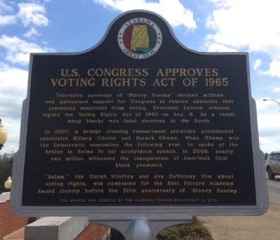
'Bloody Sunday' Attack at Edmund Pettus Bridge
A voting registration campaign in 1965 turned tragic Feb. 17 when an Alabama state trooper fatally shot Jimmie Lee Jackson in Marion. It prompted a protest march from Selma to Montgomery that . . . — — Map (db m81944) HM
Front As railroads were reconstructed following the Civil War, a junction of north-south and east-west lines was established along the Alabama-Florida border near the confluence of Big Escambia Creek and the Conecuh-Escambia River. A . . . — — Map (db m47484) HM
While helicopters buzzed overhead, National Guard soldiers—ordered by President Lyndon Johnson to protect the marchers—lined U.S. Highway 80, alert to the potential of violence by angry whites. Marchers walked mile after tired mile, while black . . . — — Map (db m112384) HM
Following two attempted marches from Selma in 1965
civil rights leaders turned to the federal courts for legal
protection prior to the Selma To Montgomery March.
Federal District Court Judge Frank M. Johnson, Jr.,
appointed by President . . . — — Map (db m91321) HM
On Thursday, March 25, 1965, the Selma to Montgomery
marchers left St. Jude and continued through the streets
of Montgomery, the crowd swelling in numbers as they
approached Court Square. By the time they reached
Dexter Avenue, a crowd of more . . . — — Map (db m91322) HM
[Written on the initial marker, provided for context]
Our Constitution names the President of the United States the Commander in Chief of all the Armed Forces. Presidents who have served in our military are displayed on the following . . . — — Map (db m92423) HM WM
The park was created by the State of Delaware for the tercentenary in 1938. It was designated a National Historic Landmark by the U.S. Department of the Interior March 29, 1963 in the presence of Prince Bertil of Sweden, Vice President Lyndon B. . . . — — Map (db m174432) HM
Economist Robert Clifton Weaver (1907-1997) was born in Washington and grew up here in Brookland. After graduating from Dunbar High School, he earned three degrees in economics from Harvard and moved into a long career in government service. Weaver . . . — — Map (db m111796) HM
Three dramatic religious structures dominate this corner. They are among some 40 religious institutions lining 16th Street between the White House and the Maryland state line.
Many serve as unofficial “embassies” representing the . . . — — Map (db m152206) HM
From 1927 until the late 1950s, the landscaped grounds across the street were the Hillcrest Children’s Center. It was founded downtown in 1814 as the Washington City Orphan Asylum by Marcia Burnes Van Ness and President Madison’s wife Dolley. . . . — — Map (db m130930) HM
Originally State, War, and Navy Departments Constructed 1871-1888 South Wing Ground broken June 1871 Completed December 1875 East Wing Ground broken July 1872 Completed April 1879 North Wing Ground broken July 1879 Completed December 1882 West . . . — — Map (db m71253) HM
The Roster of LeDroit Park's accomplished African Americans is long. Consider these prominent Washingtonians who lived on T Street.
Walter E. Washington and his wife, Bennetta Bullock Washington, lived with her family at 408 T Street. Mrs. . . . — — Map (db m152367) HM
Belford V. Lawson (1909–1985) and Marjorie M. Lawson (1912–2002) were prominent attorneys. Mr. Lawson helped win landmark civil rights cases before the U.S. Supreme Court, including New Negro Alliance v. Sanitary Grocery (1938) and . . . — — Map (db m79362) HM
Through The 1960s President Lyndon B. Johnson and his family worshipped across the street to your left at National City Christian Church. The First Family sat near the front in the pew deemed safest by their Secret Service agents. The church . . . — — Map (db m130858) HM
The body of water that inspired the line in Howard University’s alma mater, “far above the lake so blue stands old Howard firm and true,” is McMillan Reservoir, which opened in 1902 to supply water to the city. The reservoir and . . . — — Map (db m130766) HM
Real Justice
The Spirit of
Thurgood Marshall
7-2-08 to 1-24-98
I still believe firmly that the right will win out.
Justice for all people, regardless of race, creed or color.
The long-time NAACP lawyer who argued successfully in . . . — — Map (db m88468) HM
First Lady Claudia Alta Taylor Johnson, known as Lady Bird, is famous for her nationwide beautification initiatives. When she served as First Lady from 1963 to 1969, she championed legislation concerning pollution, conservation, urban renewal, . . . — — Map (db m181397) HM
"This strip of land will always be a special place for me… It appears at the moment when you come over a rise and look down into the Potomac Valley and see the capital spread out with its great monuments."
- Claudia Alta . . . — — Map (db m181393) HM
Today, we proclaim our refusal to be strangled by the wastes of Civilization. Today, we begin to be the masters of our environment.
Lyndon B. Johnson at the signing of the Water Quality Act of 1965
Who are these famous Civil Rights leaders?
Barbara Jordan (upper left)(some text missing due to illegibility)
Patsy Mink (wearing... (some text missing due to illegibility) ... supporter of civil rights . . . — — Map (db m130649) HM
Thurgood Marshall (July 2, 1908-January 24, 1993), the great-grandson of slaves, was the first African-American justice appointed to the United States Supreme Court. Where he served from 1967 to 1991. Earlier in his career, Marshall was a . . . — — Map (db m179223) HM
The Price of Progress Picture massive barges, tugboats and trawlers clogging the bay. This was to be the west end of the Cross Florida Barge Canal, where the water enters the Gulf of Mexico. The canal would have impacted Florida's fresh and . . . — — Map (db m167343) HM
The second United States occupation of the Dominican Republic began when the United States Marines Corps entered Santo Domingo on April 28, 1965 in the Dominican Civil War. They were later joined, beginning the following day by most of the United . . . — — Map (db m194506) WM
Roosevelt EraThe Cross Florida Canal got its start during the Great Depression years. President Franklin D. Roosevelt's efforts to revive the nation's ailing economy involved a wide array of projects and jobs funded by tax-payers. The . . . — — Map (db m237438) HM
On this site, which was officially known as the Florida City Shelter of the Catholic Welfare Bureau’s Children’s Program, thousands of Operation Pedro Pan children found refuge from Communist Cuba between 1961 and 1966. Operation Pedro Pan . . . — — Map (db m71917) HM
The Edge of "Progress" (English)
Imagine standing at this spot and watching tanker ships approach an oil refinery directly ahead of you. In the distance to your right, a causeway connects the Florida mainland to a new city on the . . . — — Map (db m131792) HM
Lieutenant Colonel Jackson was the aircraft commander of an unarmed C-123 transport flying a tactical emergency evacuation mission to rescue three remaining survivors at the Special Forces camp at Kham Duc, Republic of Vietnam, on 12 May 1968. The . . . — — Map (db m99813) HM
Major Fisher was an A-1E pilot at A Shau, South Vietnam on 10 March 1966. The Special Forces camp was attacked by 2,000 North Vietnamese Army Regulars. Tops of 1,500-foot hills were obscured by an 800-foot ceiling, limiting maneuverability and . . . — — Map (db m99811) HM WM
Civic Rights Activist, Trade Union Leader, Crusader for Justice 1889–1979
“Salvation for a race, nation or class must come from within. Freedom is never granted; it is won. Justice is never given; it is exacted.”
Asa Philip . . . — — Map (db m5514) HM
"God Was Good to this Country" On a rainy February day in 1964, President Lyndon Johnson spoke to a crowd near here. "God was good to this country… He gave us great estuaries, natural locales for harbors, but he left it to us to dredge them out . . . — — Map (db m167899) HM
Two and a-half miles to the east, at Rodeheaver Boys Ranch, President Lyndon B. Johnson, on February 27, 1964, dedicated the Start of Construction on the 185-MILE CROSS FLORIDA BARGE CANAL. An estimated audience of 15,000 attended. — — Map (db m129568) HM
1 • Mount Vernon Red Maple Planted in honor of the Founders of the City of Sanford, Florida on February 10, 1992. This red maple has been grown from seeds collected at Mount Vernon, President George Washington's beloved home on the . . . — — Map (db m214875) HM
1 • Ponce de León Live Oak Planted on November 27, 2001 in memory of Eunice R. Rabette. The Ponce de León Live Oaks grow near the spot at Port Charlotte, Florida, where the explorer first came ashore in April 1513. 2 • Treaty Live . . . — — Map (db m214873) HM
The Vietnam War began when Vietnamese nationalists ended one hundred years of colonial rule by forcing the French out of the country. The 1954 Geneva Peace Accords divided the country into North and South Vietnam to separate the opposing groups . . . — — Map (db m57568) HM
At this location on June 9th, 1964, Civil Rights Movement Leader Andrew Young led a march from Lincolnville to the Plaza de la Constitución where they met violent opposition. Young had been sent to St. Augustine by the Reverend Martin Luther King, . . . — — Map (db m107336) HM
Carl Vinson, native son, farmer, lawyer, statesman, served in the United States Congress for 50 years;
Chairman of the Naval Affairs Committee; Chairman of the Armed Services Committee;
an advocate for Military Preparedness; He was credited with . . . — — Map (db m42626) HM
Francis L. Sampson
1912-1996
Francis L. Sampson's amazing record as a war hero put him in history books. As the "Paratrooper Padre" in World War II, he was one of the 20th century's best-known Army Chaplains. His real life story of . . . — — Map (db m126926) HM WM
Civil Rights Activist Author
In 1948, Alice Dunnigan was first black reporter on campaign trail with a president--Truman. Under Presidents Kennedy and Johnson, she was member of President's Committee on Equal Opportunity. Author of: A . . . — — Map (db m123369) HM
This Union Countian became governor following service in WW I, then as sheriff, county clerk and judge, state senator. As governor, 1947-1950, Clements spurred massive industrialization effort as well as road and state parks development. Resigned to . . . — — Map (db m123606) HM
Panel 1 Much like the Korean War before it, the Vietnam War started as a civil war in Asia, but quickly evolved into an international matter because it became yet another manifestation of the Cold War. By 1954, a communist regime controlled . . . — — Map (db m208813) WM
1954 Communist forces win decisive victory over French at Dien Bien Phu. Geneva Accords divide Vietnam. Southeast Asia Treaty Organization is formed. President Dwight D. Eisenhower offers aid to South Vietnam. 1955 One Million Vietnamese . . . — — Map (db m106032) HM WM
New Orleans maps, as early as 1720, all reveal the presence of earlier buildings on this historic site. During the time of Spanish Rule, after the Great Conflagrations of 1788 and 1794, Casa Quinones was erected in 1795 by Don Estevan de Quinones, a . . . — — Map (db m51377) HM
Navy-Marine Corps Memorial Stadium has been called a "Memorial that happens to be a stadium". While visitors and athletes for nearly 50 years have been inspired by the campaigns and battles emblazoned around the stadium facade, much more needed . . . — — Map (db m127935) HM WM
Working with the Mutual United Brotherhood of Liberty (MUBL), a small group of African American lawyers living in Baltimore were committed to erasing racism within the law. But first they had to fight for the right to practice law in Maryland, . . . — — Map (db m168769) HM
One half mile to the west of this plaque, the gap in South Mountain, the Appalachian Trail footbridge, and I-70 symbolically form the Bill Pate Portal to the Appalachian region—a region where a people and their governments joined in a national . . . — — Map (db m167360) HM
A picturesque fieldstone chapel built as a memorial to Harriet McPherson Brien, wife of John Brien, owner of Catoctin Iron Furnace. Harriet Chapel would become a place of worship for members of the Episcopal Church in 1833. Most church services . . . — — Map (db m184185) HM
In the mid-1960s, the water quality of the Potomac River was unhealthy. In 1965, President Lyndon Johnson called the river a "national disgrace." Development and public neglect had allowed the river to become polluted with sediment, sewage, and . . . — — Map (db m127729) HM
World War II was the last fought in which the President asked Congress for a declaration of war. Since then, United States armed forces have been in combat, including these smaller conflicts:
Cuba 1961
The U.S. orchestrates the . . . — — Map (db m150158) HM
Known as the “Mother” of Michigan State Parks system. Genevieve Gillette is remembered as one of the state’s most effective conservation lobbyists. In 1920, she was the only woman in the first landscape architecture class to graduate . . . — — Map (db m103684) HM
Michigan state parks welcomed the newly-mobile drivers
of automobiles in the early 1900s. Genevieve Gillette made it her life's work to preserve precious natural settings and make them available to the travelling public. In 1920 she began . . . — — Map (db m99055) HM
President Lyndon B. Johnson, Senator Hubert H. Humphrey, and Governor Karl Rolvaag enjoy the spray from Minnehaha Falls. On that day in 1964, however, Minneapolis was experiencing a drought. In order to create the beautiful display of the falls . . . — — Map (db m41153) HM
Front
Aaron Henry (1922-1997), Clarksdale pharmacist, was a major early grassroots activist in the civil rights movement. As local NAACP president, he led the early 1960s Clarksdale boycott campaign, during which he was arrested and . . . — — Map (db m170477) HM
Front
Medgar and Myrlie Evers moved into this
home with their children - Darrell and Reena -
in 1955 after Medgar became Mississippi's first
NAACP Field Secretary. Son Van was born in
1960. Evers was an outspoken activist for . . . — — Map (db m115401) HM
Side 1 Elected president of the Pike County branch of the NAACP in 1954, Curtis Conway Bryant (1917-2001) played a major role in early civil rights activism of southwest Mississippi. He campaigned to expand membership in the NAACP, led large . . . — — Map (db m108990) HM
text from: Nevada State Historic Preservation Office
Located 13 miles to the north is the camp of Wonder, a major mining center in the early years of the twentieth century. Thomas J. Stroud and several others made the first locations in . . . — — Map (db m69651) HM
Theodore Roosevelt became President of the United States while in Newcomb during the early morning hours of September 12th, 1901. Earlier in the day he was descending from Mount Marcy when a guide reached him with information that President McKinley . . . — — Map (db m147527) HM
The Cold War (1946-1991) Peace Operations (1991-2000) Shortly after its victory in World War II, the United States faced new international security challenges. The Soviet Union established Communist governments in central and eastern Europe and . . . — — Map (db m35504) HM
Heads of State
who visited the
New York Worlds Fair
1939 - 1940
Herbert C. Hoover, USA •
Franklin D. Roosevelt, USA •
George VI, Great Britain •
Anastasio Somoza, Nicaragua
1964 - 1965
Herbert C. Hoover, USA •
Harry . . . — — Map (db m193429) HM
Susan Brownell Anthony
Woman Suffrage Leader
Visited October 19, 1878
"To secure both national and 'domestic tranquility,' to 'establish justice,' to carry out the spirit of our Constitution, put into the hands of all women....the . . . — — Map (db m53838) HM
Side A: William Moore McCulloch
William McCulloch was born in Holmes County where he was educated in a one-room schoolhouse before moving to Wooster to attend high school and the College of Wooster. He attained prominence as Ohio's Speaker of . . . — — Map (db m29828) HM
35 years of dedicated service
Veteran of Korea and Vietnam
A member of the ground crew on
Columbine III – Air Force One
President Kennedy and President Johnson
Member of the 4950th Test Wing — — Map (db m82720) HM WM
For sustained professional performing
as a combat ready aircrew member.
Established by military regulation on March 9, 1964,
during the Presidency of Lyndon Baines Johnson. — — Map (db m232265) HM WM
(1956-1973) The Geneva Agreement of 1954 dictated that Vietnam would be divided into two countries at the 17th parallel, creating a communist-backed North Vietnam and a US-backed South Vietnam. American military aid and advisors started . . . — — Map (db m232038) WM
Top Left
First called "Blood's Settlement", and then later Marien, then Marienville, after Marien (Blood) Hunt, daughter of Cyrus Blood, the founder of Forest County. Marienville is located on a flattened ridgeline known as the "Big Level", . . . — — Map (db m138604) HM
Conservationist and architect of National Wilderness Preservation System Act of 1964. Although he died four months before President Lyndon Johnson signed the bill, his efforts led to the preservation of over 100 million acres across the nation. . . . — — Map (db m39881) HM
Designer of the reverse side of the Lincoln Penny and, with Gilroy Roberts, the Kennedy half-dollar. Born and educated in classical art in Philadelphia, Gasparro was first employed as a junior engraver by the U.S. Mint in 1942. By 1965 he was . . . — — Map (db m81640) HM
President Johnson is one of only four people who served in all four elected federal offices of the United States: representative, senator, vice-president and president. Johnson succeeded to the presidency following the assassination of John . . . — — Map (db m193237) HM
In 1961, Dominican Republic Dictator Raphael Trujillo was assassinated. In the following years, turmoil and conflict were the order of the day on the island. President John F. Kennedy made it clear that it was time for democracy in the Dominican . . . — — Map (db m102073) WM
The United States never wavered in its commitment to freedom and democracy in Berlin, a city isolated 100 miles inside Easts Germany. In 1948, to assert its influence over Germany, the Soviet Union blockaded land access to Berlin. The Western . . . — — Map (db m136414) WM
On Oct. 8, 1918, outside the French village of Chatel-Chenery, Alvin C. York took his fateful walk into history during the Meuse-Argonne Offensive against the German forces. As the sharpshooter for Company G in the 328th Infantry of the U.S. Army, . . . — — Map (db m81525) WM
Originally known as Pecan Grove Baptist Church, this fellowship was organized in 1873 by the Rev. M.V. Smith, the Rev. H.I. Kimball, and the Rev. G.W. Baines, great-grandfather of United States President Lyndon Baines Johnson. In 1884 the church was . . . — — Map (db m29036) HM
Built in the 1860s, this house was the residence of the Rev. George Washington Baines (1809-83) from 1870 to 1883. A pioneer Baptist preacher, missionary, editor, and educator, the Rev. Baines was the great-grandfather of United States President . . . — — Map (db m29313) HM
Officially opened on May 17, 1953, Cora Anderson Negro Hospital offered medical services to the growing African American population of Temple and greater Bell County. The hospital featured 16 patient rooms and a surgical suite. It was located only . . . — — Map (db m131552) HM
From this headquarters site in the 1870s, the brothers J. T. and Sam Ealy Johnson started thousands of cattle up trails to Kansas and other shipping or market points. To the west, at Williamson's Creek, and at Deer Creek (southeast) the Johnsons had . . . — — Map (db m35352) HM
Built by Johnson City founder James Polk Johnson (1845-1885), this structure has housed a variety of businesses and served as a community gathering place. In addition to serving as a community hall, opera house, and meeting place for churches and . . . — — Map (db m31126) HM
“It was just a big family town. Nobody was rich, and everybody had plenty to eat and plenty to wear, and Lyndon was no different from the rest of us. I miss that little town, that feeling that everybody would do anything for anybody else. . . . — — Map (db m31098) HM
The sidewalk ahead leads to the Johnson Settlement, frontier home of President Johnson's paternal grandparents, Samuel Ealy Johnson, Sr., and Eliza Bunton Johnson.
Between 1867 and 1872 Sam Ealy Johnson, Sr., and his brother Tom drove huge herds . . . — — Map (db m31097) HM
Lyndon Johnson spent most of ten years living in this home - a decade that profoundly affected the future president's view of the world.
A neat landscape in front of you bears little resemblance to the backyard Lyndon Johnson knew. In Johnson's . . . — — Map (db m31036) HM
By the 1930s, many residents of cities across the U.S. were benefiting from the common use of electricity. However, a vast majority of rural areas lacked electric service, which compounded depression-era problems for farmers whose crop returns were . . . — — Map (db m126764) HM
Born in Alabama on August 24, 1845, James Polk Johnson was still a child when his family moved to Texas in search of a better life. As a teenager he served in the Civil War and then joined his uncles Tom and Sam Ealy Johnson in their cattle droving . . . — — Map (db m127310) HM
Just as Johnson City helped shape Lyndon Johnson, Lyndon Johnson helped shape the modern face of Johnson City. Throughout the town are buildings that reflect Johnson's quest to ease the hardships he knew here in his youth. The former LBJ Hospital - . . . — — Map (db m31128) HM
Near this point on November 22, 1963, Vice-President Lyndon Baines Johnson took the oath of office as 36th President of the United States. He is the first Texan to hold the office of President.
The ceremony was held in the central compartment of . . . — — Map (db m97767) HM
Beyond the Pedernales is Stonewall’s Project Head Start building—a symbol of one of President Johnson’s enduring legacies to the American people. President Johnson initiated the Head Start program in 1965; it was one of many programs that . . . — — Map (db m91184) HM
For many years this low-water crossing served as the primary access to the LBJ Ranch; for non-Texans, it served as a dramatic entry into Lyndon Johnson’s world.
Constructed in 1951, the dam and crossing were the first improvements Lyndon . . . — — Map (db m91131) HM
It is a Society where no child will go unfed, and no youngster will go unschooled .... Where no citizen will be barred from any door because of his birthplace or his color .... Where peace and security is common among neighbors and possible . . . — — Map (db m91183) HM
I first remember walking along the banks of the Pedernales when I was a boy four or five years of age.
Lyndon Baines Johnson
The Pedernales River carves out the landscape of the Texas Hill Country, stretching 106 miles from . . . — — Map (db m91182) HM
In 1951, Senator Lyndon Johnson purchased 240 acres from his Aunt Frank Martin. Beginning with this core property, he set out to establish a home base where he could continue his work away from Washington.
To improve access to the ranch, a 3000 . . . — — Map (db m91282) HM
Imagine a plane roaring onto a newly constructed 3,000 foot grass airstrip. It’s 1953, and Senator Lyndon Johnson has arrived at the LBJ Ranch. Initially built to improve access to the Ranch during floods, the small airstrip soon proves inadequate . . . — — Map (db m91268) HM
The LBJ Ranch had but a single telephone line when Lyndon Johnson purchased the property in 1951. By the time he became vice president in 1960 the array of technology had grown to 15 local and long-distance phone lines as well as a fifty-foot-tall . . . — — Map (db m91283) HM
To a Texas rancher like Lyndon Johnson, conservation meant getting the most from the soil, water, and grass. The landscape before you reflects some of President Johnson’s conservation efforts. These upper fields are terraced to control erosion and . . . — — Map (db m91234) HM
Sitting at a table on this site on April 11, 1965, President Johnson signed the landmark Elementary and Secondary Education Act of 1965. “As a former teacher,” the president said, “I have great expectations of what this law . . . — — Map (db m91135) HM
1900 - 1920
The Dawn of a New Century
The years following the turn of the century heralded sweeping changes in agriculture throughout Texas and the nation. Advances in technology led to improved irrigation and farming methods . . . — — Map (db m91053) HM
For Lyndon Johnson, a traditional guest register was not enough. To commemorate the visits of dignitaries and friends to the Ranch, the Johnsons used “Friendship Stones.” Visitors etched their autographs and the date of their visit into . . . — — Map (db m91314) HM
140 entries matched your criteria. The first 100 are listed above. The final 40 ⊳