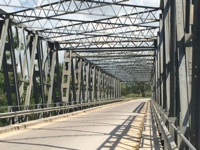
This bridge was inaugurated on July 05, 2005 by Hon. Said Musa, Prime Minister of Belize, in tribute to the late Hon. Agripino Cawich whose vision and determination made this construction a reality. This 114 m Calendar Hamilton Truss Bridge System . . . — — Map (db m81220) HM
Near Bliss Parade just east of Constitution Drive, on the left when traveling east.
“Del pueblo de Mexico al pueblo de Belize, en ocasión del X Aniversario de su Independencia. Inaugurado por el Presidente de Mexico, Carlos Salinas de Gotari, Septiembre de 1991.” English: “From the . . . — — Map (db m118896) HM
On Constitution Drive at North Ring Road, in the median on Constitution Drive.
Colossal Head ReplicaCulture: Olmec Temporality: Early Preclassic 1200-900 BC. Discovered: 1970 Place of origin: Texistepec, State of Veracruz, Mexico Site: San Lorenzo Tenochtitlan Measures: Length: 1.63 m Width: 1.55 m Height: 2.20 m Author: . . . — — Map (db m118867) HM
On Price Center Road, on the right when traveling east.
Father of Belize's Independence 1981 Founder of the City of Belmopan 1970 A man who has dedicated fifty eight (58) years of his life to the Government and people of Belize — — Map (db m94508) HM
Near Bliss Parade just east of Constitution Drive, on the left when traveling east.
The flag of Belize is made up of Blue (Azure) with a White circle and a Red (Gules) border, these two horizontal red borders are 1/5 of the total width of the Flag, with the Coat of Arms centered
on the white circle. The shield of the Coat of . . . — — Map (db m133812) HM
On Western Highway just east of Eve Street, on the left when traveling east.
About Location
Esperanza is located approximately two and a half miles northeast of San Ignacio and abuts the town of Santa Elena.
Population
1,262 as of the 2010 census
Highlights:
Farming, Construction, River
Esperanza is the . . . — — Map (db m196275) HM
This altar is a ballcourt marker erected in A.D. 633 by Lord Kan II. The text explains that Kan II's father, Lord Water, engaged in two war events with Tikal in A.D. 556 and A.D. 562. The unstated purpose of the monument is to compare Kan II's . . . — — Map (db m94539) HM WM
On Joseph Andrews Drive just north of Savannah Street, on the left when traveling north.
Dedicated to the people of San Ignacio & Santa Elena commemorating The Centennial of El Cayo October 19-1904-2004 by the Hon Said W. Musa Prime Minister of Belize 19th October 2004 Sponsored by Atlantic Bank Limited San . . . — — Map (db m118897) HM