Historic Kilfenora
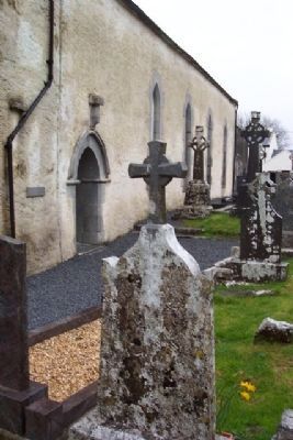
The monastery of Kilfenora or Chill Fhionnúrach (the church of the white brow) is said to have been founded in the 6th century by St. Fachnan. The outline of the early monastic circular enclosure can still be traced in the . . . — — Map (db m23694) HM
Kilfenora was the diocese of the Kingdom of Corcomroe and was the smallest diocese in medieval Ireland.
Although a monastery was founded here more than 500 years earlier by St Fachtna, Kilfenora only became significant when it was officially . . . — — Map (db m22990) HM
On Local Route L2011, 1 kilometer south of Munster Route R585, on the left when traveling south.
Welcome to the Ambush Site at Beal na Blath, where General Michael Collins, "Commander-in-Chief" of The Irish Army, was assassinated on 22nd August 1922.
Michael Collins and his party left Cork City at approximately 6am that morning, on . . . — — Map (db m139617) HM
English:
Cove Fort was built by Vice-Admiral Malcolm, the first Naval Commander of the Navy garrison in Cobh, in the mid 18th Century as a fortification for the garrison. The Fort comprised of a barracks, with 3 tiers of twenty four . . . — — Map (db m85827) HM
This area has been a place of worship and burial from Celtic times to the present day. The great diversity of history and culture of Cobh is reflected on the many headstones and epitaphs of those interred here among them, Jack Doyle, Dr. James Roche . . . — — Map (db m85823)
The Cunard Liner, torpedoed and sunk by U Boat U20 off the Cork Coast on 7th May, 1915,
With the loss of 1198 lives.
Many survivors and dead were brought ashore here.
170 of the victims were buried in the nearby
Clonmel (Old Church) Cemetery. . . . — — Map (db m85818) HM WM
On Beechmount, 0.1 kilometers east of Thomas Kent Street, on the right when traveling east.
Táimid réidh anois, a cheannasaí!
Nauair a shroich an Ceannasaí Seosaimh K. Taussig, Cabhlach na Stáit Aointaithe Meiriceá, Cóbh ar 4ú Bealtaine 1917, bhí scuadrún longa cogaidh SAM ina dteannta chun teacht i . . . — — Map (db m163613) HM
On Munster Route R603, on the right when traveling north.
Kilbrittain Castle is the oldest inhabited castle in Ireland. The Castle is said to date from 1035 where the original fortress was thought to have been built by Mahon, grandson of Brian Boru. It has been occupied by Irish chieftains, . . . — — Map (db m139602) HM
On Munster Route R603, on the right when traveling north.
THE BOOK OF LISMORE. It is believed that the Book of Lismore was compiled in the 15th Century to commemorate the marriage of the Gaelic lord Finghin Mac Cárthaigh Riabhach, of Kilbrittain Castle, to Caitilín, daughter of the seventh . . . — — Map (db m139606) HM
Annie Moore and her brothers Anthony and Philip embarked from this town on 20 December, 1891 on the S.S. Nevada. Annie was the first person to be admitted to the United States of America through the new immigration centre at Ellis Island, New York . . . — — Map (db m85821) HM
On Cork Street at Chairmans Lane, on the left when traveling north on Cork Street.
Thóg Maurice Bacach Fitzgerald, larla Dheasmhumhan Caisleán Deasmhumhan c. 1500. Sampla maith de theach túir uirbeach, is éard atá sa chaisleán ná daingean le tithe stórais ar cúl agus oifigí tí ar an gcéad agus ar an dara hurlár. Tógadh . . . — — Map (db m137073) HM
On Friar Street just west of Cork Street, on the right when traveling west.
Sna 1830'aidí, ag deireadh ré na bPéindlíthe, tógadh Séipéal Eoin Baiste, in áit foirgneamh díon tuí a bhí níos lú. Dhear an Bráthair Michael Augustine O'Riordan an stíl clasaiceach atá air agus dhear sé roinnt séipéal eile i gCorcaigh . . . — — Map (db m137067) HM
On Market Lane, on the right when traveling north.
Múseum (Teach na Cúirte)
Teach na Cúirte atá anois air ach be é Teach an Mhargaidh é ar dtús, croilár tráchtála an bhaile áit a mbítí ag trádáil sna háirsí ar urlár na talún. Tógadh é thart ar 1600. Dúnadh roinnt de na háirsí i 1706, . . . — — Map (db m137111) HM
On Pearse Street (Munster Route R605) at Market Lane/The Glen, on the right when traveling north on Pearse Street.
We recently completed the restoration of the Old Kinsale Fish [M]arket wall adjoining the Blue Have[n] Hotel which now forms the entrance to the Blue Haven Bar and surrounding areas. The Blue Haven Hotel is built on the site of the Old Fish . . . — — Map (db m137173) HM
On Pier Road (Munster Route R600) 0.3 kilometers south of Emmet Place, on the left when traveling south.
I 1588 shocraigh Philip III, i ndiaidh theip Armáid na Spáinne agus scrios phéire eile i stoirmeacha i mblianta deiridh Philip II, go dtabharfadh sé tacaíocht dhíreach do lucht éirí amach na hÉireann a bhí ag troid Shasana le súil agus go . . . — — Map (db m137476) HM
On Cork Street (Munster Route R600) at Market Lane, on the left when traveling south on Cork Street.
Tógadh Rinn Chorráin déanach sa 17ú céad ar shuíomh dhaingniú chósta níos luaithe. Is sampla claisiceach é de dhún réaltógach. Tá Rinn Chorráin ar cheann de na dúin mhíleata is mó sa tír agus tá ceangal aige le cuid de na heachtraí is . . . — — Map (db m137242) HM
On Pier Road (Munster Route R600) just south of Emmet Place, on the right when traveling north.
Tar éis Chath Chionn tSáile thosaigh obair thógála ar An Seandaingean i 1602 faoi stiúrthóireacht an Innealtóra Paul Ive. Críochnaíodh é i 1604 ar chostas £645. Is dún mór, urdhúnta, peinteagánach, é An Seandaingean agus é taobh istigh de . . . — — Map (db m137244) HM
On Church Square just west of Cork Street, on the right when traveling west.
Timpeall 1200 thóg na Normannaigh Teampall Mheilteog ar shuíomh an aireagail 6ú aoise agus níl mórán athrú déanta air, agus é ina ionad adhartha ag Críostaithe sa mbaile ó shin. Tá túr suntasach ann agus roinnt fuinneoga daite agus . . . — — Map (db m137360) HM
On Pier Road (Munster Route R600) at Emmet Place, on the right when traveling south on Pier Road.
The restored Fish Shed (using recycled material) is a living link with Kinsale's thriving fishing industry of old. Hundreds of Kinsale hookers, small inshore craft with 3 man crew, were joined by fleets from other parts of Ireland, the Isle of . . . — — Map (db m137269) HM
On Market Square at Guardwell, on the right when traveling east on Market Square.
Kinsale is a sea-port, parliamentary borough, and market town, in the parishes of Saint Multose and Ringcurran barony of Kinsale, County of Cork, 172 miles s.w. from Dublin, 12½ s. and 11 e.s.e. from Bandon; eligibly situated near the . . . — — Map (db m137282) HM
On Market Lane at Milk Market, on the right when traveling west on Market Lane.
there were four walled towns in county cork: cork city, youghal, bandon and kinsale. as with walled towns all over europe in the middle ages, the purpose was to provide security against attack and to create a commercial and political entity. in . . . — — Map (db m137145) HM
On Market Street at Milk Market, on the right when traveling west on Market Street.
History: Kinsale Town Wall
In the year 1381, King Richard II of England declared that the town of Kinsale being situated on the sea shore and of late having recieved [sic] insult and attack from Spanish and Irish enemies and . . . — — Map (db m137118) HM
On The Glen (Munster Route R605) just north of Market Lane/Pearse Street, on the left when traveling north.
Restaurant D'Antibes dedicated to the
formal twinning between
Kinsale-Cionn TSáile and Antibes-Juan Les Pins
Signed by Cllr. Michael Frawley
Chairman of Kinsale U.D.C.
and M. Pierre Merli, Mayor of Antibes-Juan Les Pins
on 28th of . . . — — Map (db m137170) HM
On Pier Road (Munster Route R600) 0.3 kilometers south of Emmet Place, on the left when traveling south.
In memory of
all lost seafarers
from the port of Kinsale
Kinsale Hooker
19th c. Fishing vessel
His hooker's in the Scilly Van
when seines are in the foam
but money never made the man
nor wealth a happy home.
So, blessed . . . — — Map (db m137497) HM
The Kinsale Tidy Towns project for 2018 was for the erection of this sign which details a number of nautical items which are stored here at the back of the Museum (see photos No's 1,2 & 3). It entailed some restoration work on some of the items, . . . — — Map (db m137116) HM
On Market Lane, on the right when traveling north.
Peter Barry arrived in Kinsale in 1963 and settled in Scilly where he made his home. In those early years he operated and developed Scilly's unique Spaniard Pub and the Man Friday restaurant, and later the Grey Hound Bar in Market Place.
Peter . . . — — Map (db m137075) HM
On Market Lane at Milk Market, on the right when traveling west on Market Lane.
Up to this time, William Smith & Sons had relied almost entirely on the increasing trade in sweepers, scrapers, spare parts and brushes. The range of machines available had been frequently updated and fifteen types of sweepers were now being . . . — — Map (db m137148) HM
On Church Square just west of Cork Street, on the right when traveling west.
In the days when Kinsale was a great maritime centre it was an important port of call for fresh water. It was known in Irish as Fan na dTubraid, the Slope of the Springs/Wells and there were many public and private wells in the town. Some were the . . . — — Map (db m137271) HM
On Market Square at Guardwell, on the right when traveling east on Market Square.
The Town Pound was an essential part of the administration of the old town, located near the Market House, the Potato Market and the Broadstone. It had replaced the Old Pound at the top of Barrack Street and was for the care of stray livestock, . . . — — Map (db m137294) HM
On Pearse Street (Munster Route R605) at Market Lane/The Glen, on the left when traveling north on Pearse Street.
This plaque
commemorates the official opening
of the refurbished premises by
The Honourable Patrick J. Kennedy,
Member of Congress,
Rhode Island, USA.
14th. April, 1998. — — Map (db m137169) HM
On West Square just south of Castle Street (National Route N22), on the left when traveling south.
Commemorating
the visit of
President
Mary Robinson
February 24th
1996
——————————
Commissioned
and
Unveiled
by
Dermot Desmond
First recipient of
The . . . — — Map (db m139626) HM
On West Square just north of South Square, on the left when traveling north.
Bealick Mill
This recently restored corn mill, located a short distance outside Macroom on the Coachford road, marks the site of an area and a building of deep historical significance. In 978 Brian Boru defeated the Danes, for . . . — — Map (db m139654) HM
History.
The first Castle is thought to have been built here in the reign of King John between 1200 and 1250. Macroom Castle was the home of McCarthys, Lord of Muskerry, after the McCarthys displace[d] the O'Flynns, previous Lords . . . — — Map (db m139648) HM
On Old Head Ring Route, on the right when traveling south.
Lusitania Memorial Garden
officially opened by
Minister Simon Coveney T.D.
in the presence of
Cllr. Séamus McGrath
Mayor of County Cork.
7th May . . . — — Map (db m139595) HM
On Old Head Ring Route, on the right when traveling south.
On the 12th of February 1874, the 500 ton German barque HERCULES von BARTH, was en route from Barrow-in-Furness to Cardiff to collect a cargo of coal. As the result of a storm the ship was driven westward in a strong gale. It eventually . . . — — Map (db m139529) HM
On Old Head Ring Route, on the right when traveling south.
Arrivals and farewells
Old Head, legendary seat of the kings of the southern half of Ireland, marks the start or end of many journeys.
[Background map caption reads]
The siege and battle of Kinsale, 1601 from the . . . — — Map (db m139528) HM
On Old Head Ring Route, on the right when traveling south.
In memory of those who
sailed on the R. M. S. Lusitania
on 7th May 1915.
This perforated image has 34,513 holes
in 7 different sizes.
Manufactured by Graepel Perforators
and Weavers Ltd., Kinsale. Donated to
the . . . — — Map (db m139527) HM
On Old Head Ring Route, on the right when traveling south.
A VERY SPECIAL AND PERSONAL REQUEST
August 2017
Kilkeel, Newry, Co Down
Dear Mr Hannaway,
I am writing this letter to you personally, in the hope that the matter in question can be dealt with promptly and a satisfactory . . . — — Map (db m139562) HM
On Old Head Ring Route, on the right when traveling south.
A handcast concrete pillar
tapering to a flat top
Part of a network of
surveying stations used by
Ordinance [sic - Ordnance] Survey Ireland
for mapping
Erected 1959 — — Map (db m139559) HM
On Old Head Ring Route, on the right when traveling south.
In memory of the 1198 civilian lives
lost on the Lusitania 7th May 1915
off The Old Head of Kinsale
—————————
This memorial
was unveiled by
Hugh Coveney T.D.
Minister for . . . — — Map (db m137568) HM
On National Road 86, on the right when traveling west.
The Irish sculptor of international stature was born in Coumduff, Annascaul in 1876. His family emigrated to the USA in 1888 where he developed his artistic skills. He returned to Dublin in 1925, worked there until his death in 1943.
Among . . . — — Map (db m23075) HM
Expeditions to Antarctica
Discovery, 1901-1904
Terra Nova, 1910-1013
Endurance, 1914-1917
In recognition of his invaluable
contribution to these expeditions
and of his many acts of
selfless heroism on behalf
of his companions . . . — — Map (db m23045) HM
On Ring of Kerry (National Route N70), on the left when traveling west.
of this Parish
who commanded the
Irish UN Peace Keeping Force
in the Battle of Jadotville
in the Congo in 1961
Officially unveiled
by former Taoiseach
Enda Kenny TD
October 2017 — — Map (db m140707) HM
On National Route N70, on the left when traveling west.
Taistealaithe oíche
Tá sé seo an cheann de na háiteanna is fearr ar Domhan le bheith ag féachaint ar réaltaí na spéiew an oíche.
Is é[?]an Kerry International Dark Sky Reserve an chéad cheantar sa leathsféar thuaidh ar ar . . . — — Map (db m140708) HM
On Ring of Kerry (National Route N70) at Butter Road, on the right when traveling north on Ring of Kerry.
Bóthar an Ime / Bóthar an Chuinsailéara
Tá aithne forleathan ar an mbóthar seo, a bhí in úsáid san ochtú agus sa luath-naoú chéad déag, faoin dá anim seo. Iompraíodh im ó Chiarraí Theas ar an mbóthar seo go dtí margadh an ime i . . . — — Map (db m140842) HM
On Ring of Kerry (National Route N70) at Butter Road, on the right when traveling north on Ring of Kerry.
Diameter 1.4 million km or 100 Earth diameters
Model Size 76.2 cm
Distance from Earth: 150 million km
or Astronomical Unit (1 AU)
Orbit Period: 27 days
Atmosphere: mostly Helium and Hydrogen
Surface Temperature: 5,500°C
Star Type: . . . — — Map (db m140847) HM
On Brendan's Terrace, 0.2 kilometers east of Bridge Street, on the right when traveling east.
This Marconi Licensed college was founded here in 1911 by Maurice Fitzgerald, formerly of Ballinskelligs Cable Station.
Many wireless and cable operators were trained here, including Republican Volunteer Con Keating of Reenard, Cahersiveen. Con . . . — — Map (db m142388) HM
On O'Connell Street just north of Church Street/Ring of Kerry (National Route N70), on the right when traveling north.
In the grounds of the O'Connell Memorial Church lies the grave of Monsignor Hugh O'Flaherty.
In Rome during World War II, he bravely organised an elaborate escape network for Allied POW's and civilians. When the l[A]lies entered Rome in 1944, . . . — — Map (db m142356) HM
On Church Street/Ring of Kerry (National Route N70) just east of O'Connell Street, on the left when traveling east.
In 1879 Rev. Timothy Brosnon was appointed Parish Priest of Cahersiveen and as a great admirer of Daniel O'Connell, he hoped to erect a Church that would suitably mark the centenary of his birth in 1775. Having received an audience with Pope Leo . . . — — Map (db m142353) HM
On Ring of Kerry (National Route N70) at Carhan Road, on the right when traveling east on Ring of Kerry.
At Carhan Bridge O'Connell's home comes into view on the banks of Carhan River. He was born on August 6th 1775 at Carhan House. His parents were Morgan O'Connell and Catherine Mullane who hailed from North Cork. There were 10 siblings in the . . . — — Map (db m142604) HM
On O'Connell Street, 0.1 kilometers north of Church Street/Ring of Kerry (National Route N70), on the right when traveling north.
In the early 19th century Daniel O'Connell was very conscious of the need to educate the people of South Kerry and so he bought a rectors lodge in Bank Street. He invited nuns from the Presentation Order to come and set up a school to help . . . — — Map (db m142380) HM
On Reenrusheen Road just east of Cois Uisce, on the left when traveling east.
Leaving the town park the trail proceeds to Reenrusheen road. Locally this road is known as Primrose walk. John Primrose was married to a cousin of Daniel O'Connell and he appointed Primrose as his agent in the area. O'Connell was finding it . . . — — Map (db m142474) HM
Early in the 1830's the bringing of the Railway to South Kerry was discussed. O'Connell's idea was to see the railway touching the southern coastline and to continue from Cahersiveen to Cork via Kenmare. The line between Farranfore and Killorglin . . . — — Map (db m142461) HM
On Brendan's Terrace, 0.3 kilometers east of Bridge Street, on the left when traveling east.
Cahersiveen
Cathair saidhbhin
'The fort of Saidhbin (Little Sarah)
Saidhbin was said to be the daughter of McCarthy Mor who held the lands of Iveragh. She was given the fort and the surrounding area, on the banks of the Fertha . . . — — Map (db m142406) HM
Moving away from the Railway Bridge and the River Fertha the town park comes into view. Here was the original site of the fort of Sive which gives its name to the town of Cahersiveen. At one time there was a small village in the vicinity but very . . . — — Map (db m142468) HM
On Carhan Road just south of Ring of Kerry (National Route N70), on the left when traveling south.
The parish of Caher was once under the instruction of this 17th century Roman Catholic Church. The graveyard around the Church has recently been restored and this peaceful area of Cahersiveen is the resting place of Morgan and Catherine . . . — — Map (db m142683) HM
On Bridge Street, 0.3 kilometers north of Church Street/Ring of Kerry (National Route N70), on the right when traveling north.
The Heritage Centre came about following the defeat of the Fenians in 1867. The English government was anxious about the safety of the Valentia Atlantic cable station. A new constabulary barracks was built on the banks of the River Fertha and it . . . — — Map (db m142383) HM
On National Route N70 at Carhan Road, on the right when traveling east on National Route N70.
"The town which climbs the mountain and looks upon the sea
in sleeping time or waking that's where I want to be."
Sigerson Clifford 1913-1985
As well as being the birthplace of Daniel O'Connell, Cahersiveen has more connections with . . . — — Map (db m142607) HM
On Ring of Kerry (National Route N70) just east of Carhan Road, on the left when traveling west.
This Parkland was donated to the people of Cahersiveen in 1997 by John (Kitty) O'Sullivan, and the development was undertaken by ACARD Ltd.
Across the Carhan River you can see the ruins of Carhan House, which on 6th August 1775 was the . . . — — Map (db m142681) HM
In 1893 the Killorglin to Valentia branch of The Great Southern and Western Railway opened. The need by local farmers and fishermen to get their produce to market in Britain was identified and the provision of a grant of £85,000, from the British . . . — — Map (db m142419) HM
On Church Street (National Route N70) just west of Bridge Street, on the left when traveling east.
Tógadh an leacht so
15 cuimhne
oifigeach agus óglach
de'n tríomhadh bhriogaid
ciarraidhe
agus na laoch eile
a fuair bas ar son
poblacht na hÉireann . . . — — Map (db m142806) HM
On Ring of Kerry (National Route N70), on the right when traveling west.
It was [B]ishop Moynihans wish to build a church in Castle Cove. His reason for building a church here was, as a curate in 1917 he saw first hand the people of Castle Cove walking the long journey to Caherdaniel. When they finally reached . . . — — Map (db m140518) HM
On National Route N70 at the River Maine, on the left when traveling north on National Route N70.
Poblacht na h'Eireann,
The Provisional Government
of the
Irish Republic
to the People of Ireland.
[balance of proclamation not transcribed]
Thomas MacDonagh, Executed 3rd May 1916
Joseph Mary Plunkett, . . . — — Map (db m142791) HM
On Skellig Ring Route, on the left when traveling north.
Tobairin
Our Lady of Grace Coomanaspig
During the 1st Mass on Oct 31st 1994
concelebrated by
Fr. P Sugrue P.P & Fr. E. O'Carroll C.C.
This grotto was opened & blessed
on May 17th 1998 by Bishop of Kerry
Bishop Bill Murphy . . . — — Map (db m141169) HM
Sárstátaire Éireannach
Bhí bá ar leith ag Dónall Uí Chonaill, 'an Fuascailteoir' agus athair ghluaiseacht neamhspleáchais na hÉireann le Doire Fhíonáin. Ba é an stocaireacht a rinne sé ba chúis le hachtú Acht Fhuascailt na . . . — — Map (db m140797) HM
This group, the most westerly off the Irish coast, comprises 7 sizeable islands and isolated rocks spread in a line west by south over 2½ miles of the Atlantic, the largest (Great Blasket) 2 miles off shore.
Antiquities of the early . . . — — Map (db m24096) HM
Dunbeg Promontory Fort
This Promontory Fort consists of four fosses (ditches) and five mounds. Behind this we have the terraced dry-stone masonry rampart, originally straight but which became curved during later construction work. The . . . — — Map (db m24780) HM
Built around the 7th or 8th century this Oratory resembles an inverted boat. This is the only perfect remaining example of a number of small corbel-built Oratories on a rectangular plan. The outward inclination of the bed joints of the stonework . . . — — Map (db m23499) HM
On Ring of Kerry (National Route N70) at Munster Route R564, on the right when traveling east on Ring of Kerry.
The Great Southern and Western Railway operated a branch line of 39.5 mls. from Farranfore to Valentia Harbour for 67 yrs. The first section of the line, 12.5 mls. opened 15th Jan. 1885. The remaining 27mls. started in 1890; crossing three rivers, . . . — — Map (db m142761) HM
On Ring of Kerry (National Route N70), on the left when traveling south.
In commemoration of the 150th
anniversary of the Fenian Rising and
the efforts of John Golden and the
South Kerry Fenians
John Golden
1845 - 1883 — — Map (db m142699) HM
On The Square (National Route N71) just north of Henry Street, on the right when traveling north.
Although there had been a settlement of English colonists in Kenmare since 1670 it was not until a century later that the foundations of the present estate town were laid. This was done by William Petty-Fitzmaurice, the 1st Marquis of . . . — — Map (db m139672) HM
On The Square/Main Street (National Route N71) at Henry Street, on the right when traveling south on The Square/Main Street.
HENRY STREET - This street was named in honour of the 3rd Marquis of Lansdowne, Henry Petty-Fitzmaurice (1780-1863), who oversaw a number of major stages in the development of Kenmare. It dates from 1770s but assumed its present form . . . — — Map (db m139847) HM
On The Square (National Route N71) just north of Henry Street, on the left when traveling north.
This pub has been granted the
James Joyce Pub Award
for being an authentic Irish pub
'A good puzzle would be to cross Ireland
without passing a pub.' Ulysses
James Joyce identified and described the . . . — — Map (db m139755) HM
On The Square (National Route N71), on the left when traveling north.
Early History
Stone circles, standing stones and rock art are common around Kenmare. These archaeological sites indicate humans have lived here from the Bronze Age (c.2200-500BC). But it was the upheavals of 17th century Ireland . . . — — Map (db m139761) HM
On Main Street (National Route N71) at Henry Street, on the right when traveling south on Main Street.
MAIN STREET - Main Street was formerly named William Street in honour of the 1st Marquis of Lansdowne, William Petty-Fitzmaurice who was raised in Lixnaw, County Kerry. He inherited the Lansdowne estates at Kenmare in 1761 and became . . . — — Map (db m139850) HM
On The Square (National Route N71), on the right when traveling south.
The Market House - This three storey Classical style building was designed by renowned English architect Sir Charles Barry for the 3rd Marquis of Lansdowne. Barry (1795-1860) was a prominent architect of his time. Probably his most . . . — — Map (db m139774) HM
On The Square (National Route N71) just north of Henry Street, on the right when traveling north.
In onóir gaisigh Óglaigh na hÉireann agus laochra
Cumann na mBan a throid ar son Saoirse na hÉireann
a tógadh an leacht chuimhneacháin seo.
Erected in honour of the men of Óglaigh na hÉireann and
the women of Cumann na . . . — — Map (db m139673) HM WM
On New Line Road/Ring of Kerry (National Route N70) just south of Mill Road (National Route N70), on the left when traveling south.
As part of their preparations for the 1916 Easter Rising, the Irish Republican Brotherhood (IRB) decided on a plan to seize a wireless transmitter from the Atlantic College in Cahersiveen to contact the Aud, the German vessel which carried arms . . . — — Map (db m142785) HM
On New Line Road/Ring of Kerry (National Route N70) just south of Mill Road, on the left when traveling south.
In commemoration of
the first casualties
of the 1916 Rising
Erected at Easter 2016
—————————————
Mar chomóradh ar na
chéad taismigh . . . — — Map (db m142789) HM
On Mill Road/Ring of Kerry (National Route N70) at Market Street, on the right when traveling east on Mill Road/Ring of Kerry.
Late Captain Kerry Militia
Drowned in Castlemaine Bay
20th June 1867
when gallantly attempting to
save the life of a fellow creature
Erected
by his brother officers
of the Kerry Militia
in testimony of the affectionate . . . — — Map (db m142765) HM
Kilmalkedar — from Cill Mhaoilchéadair (the Church of Mhaoilchéadair)
Kilmalkedar Church
Kilmalkedar, one of the most important early church sites on the Dingle peninsula, is traditionally associated with St. Brendan but it was . . . — — Map (db m24299) HM
On Bridge Road (National Road 69) at the Town Square, in the median on Bridge Road.
This sculpture was designed by local councillor and craftsman Tony O'Callaghan
The “Standing Stone” illustrates the River Feale which flows around our town.
The “Ring” depicts an earthen fort situated in the . . . — — Map (db m23989) HM
On Ballybunion Road (Road 553) 0.2 kilometers west of John B. Keane Road, on the right when traveling west.
Where very many
nameless victims of the
Irish Famine of 1845-47
lie buried
Also buried here are others
who died
in the nearby workhouse
built 1840
Saibhreas na bhflaitheas dóibh! — — Map (db m23042) HM
POBLACHT NA H EIREANN.
The Provisional Government
of the
Irish Republic
TO THE PEOPLE OF IRELAND.
IRISHMEN AND IRISHWOMEN: In the name of God and of the dead generations
from which she receives bor old tradition Inationhood, . . . — — Map (db m231457) HM WM
On Main Street just west of Munster Route R565, on the right when traveling west.
The village of Portmagee was named after Captain Theobald Magee who was an officer in King James's Army. After the famous Battle of the Boyne, Magee retired from the army and became the commander of a merchant ship operating between . . . — — Map (db m141308) HM
On Main Street just west of Munster Route R565, on the right when traveling west.
This boat was built by Dan 'Denny' O'Connell in the early 1900s. He built her at the back of the Post Office, where he built all his boats, on a site which later became the local dance hall. Her purpose was to ferry people from . . . — — Map (db m141205) HM
On Main Street just west of Munster Route R565, on the right when traveling west.
Poet, fiddler, teacher, and dancing master, born in Derrynane, Co. Kerry, Tomás Rua was a supporter and close friend of the Irish Politician Daniel O'Connell.
Amhrán ne Leabhar - Song of the books.
Tomás Rua was transferred from . . . — — Map (db m141208) HM
Reask - from An Riasc (the marsh). This important early monastery was probably founded in the 6th century.
Little is known of the history of the site. The enclosing wall is roughly circular and its interior is divided by a . . . — — Map (db m24147) HM