On The Escort Way (Highway 81) at Orange Road (Highway 90), on the right when traveling west on The Escort Way.
From this vicinity Sir Thomas Mitchell's second expedition proceeded on April 7, 1835 to the Darling River, his third expedition on March 19, 1836 to Australia Felix (Western Victoria), and his fourth expedition on December 15, 1845 to Tropical . . . — — Map (db m38374) HM
On Virgil Street, on the right when traveling south.
The old town of Gungafai was built on the flats where these bridges now cross. The town was first gazetted and surveyed in 1838. The town flooded about 1 metre in 1844 and 1851.
On the 25th June 1852 the old town was destroyed by a flood 4 to . . . — — Map (db m71067) HM
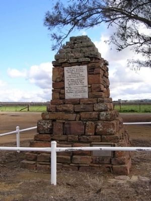
On Argyle Street west of Harrington Street, on the right when traveling west.
Captain Stanley Savige formed Legacy in 1923, as an offshoot of the Remembrance Club founded by Major General Sir John Gellibrand to help former servicemen struggling to re-establish themselves after World War I.
The Legacy Club changed its . . . — — Map (db m126551) HM
Whales (generally humpback or southern-right) can provide a magnificent spectacle off this coastline during their annual migration south, from September to November.
Many long-time residents of Tuross Head can recall the arrival of a whale on . . . — — Map (db m38375) HM
Near Chifley Road, 0.1 kilometers east of Petra Avenue.
A railway zig zag is a series of reversing ramps used to avoid very steep grades. John Whitton, Engineer in Chief NSW Government Railways 1856-90, chose this as the economical method for the descent from Clarence to Lithgow. Built during 1866-69 by . . . — — Map (db m59808) HM
On Swan Street at Berkeley Street, on the right when traveling west on Swan Street.
This historic Bakehouse was built by Richard Chapman during 1851. Chapman was a property owner, butcher and businessman of Morpeth whose residency extended from at least 1850 to his death in 1867. The building has technical value as a rare, . . . — — Map (db m70687) HM
Near Marine Parade, on the left when traveling south.
From this lookout, formally attired spectors (sic) watch a surf carnival against a sweeping panorama of thriving pines. Today high-rise buildings dwarf the trees, which were damaged by airborne pollution from North Head sewage works. Since the . . . — — Map (db m70686) HM
This marker is made up of two panels placed back to back.
Cooma 1890
During the 1880s Cooma was expanding rapidly and Sharp Street had become the town’s main thoroughfare, although settlement was still quite scattered. Some very . . . — — Map (db m70674) HM
On Lambie Street (New South Wales Route B72) at Sharp Street, on the right when traveling east on Lambie Street.
This marker consists of two plaques placed back to back.
In the 1850s Cooma was developing in two areas, one around Lambie and Mulach Street, the other over the hill where Centennial Park and Sharp Street are now. Nevertheless for the . . . — — Map (db m70675) HM
On Batlow-Tumbarumba Road at Old Tumbarumba Road, on the right when traveling south on Batlow-Tumbarumba Road.
The White Gate was a well-known landmark last century. By 1910 it was old and lying beside the posts which were still standing. The original White Gate was erected at the junction of the Batlow-Tumbarumba and Old Tumbarumba roads, marking the . . . — — Map (db m95910) HM
Near Mrs Macquaries Road, on the left when traveling north.
Don't miss this notable landmark — Mrs Macquaries Chair is just around the corner to your right. It is actually a carved rock ledge seat where Elizabeth Macquarie, the Governor's wife, liked to sit and admire the view of the harbour. Her husband had . . . — — Map (db m185648) HM
On Peel Street just north of Darling Street, on the right when traveling south.
Tamworth N.S.W. was the first town in Australia to introduce electric street lighting by means of two 18kw steam driven Crompton dynamos. Electricity was supplied to 52 street lights using 140 Swan incandescent lamps and 7 Crompton carbon arc lamps. . . . — — Map (db m70695) HM
On Marius Street close to Brisbane Street, on the right when traveling south.
For Australia
1962 – 1973
Their bodies are buried in peace and their names liveth for evermore
Killed in Action
From
Tamworth Region
213780 Pte Wilson M.A.F.
1 RAR 8 Jan 66
2781465 2 Lt Sharp G.C.
6 RAR 18 Aug 66 . . . — — Map (db m71048) WM
Stannum House
Built in 1888 “Stannum” Latin for tin, hence the owner, Mr. John Holmes Reid made the first of his fortune in tin mining.
Stannum is a Victorian-Italiante villa, triple brick, double airflow system with granite . . . — — Map (db m70697) HM