On Main Street (Oregon Route 7) near Valley Avenuee, on the right when traveling north.
Mary Alfred was one of Baker City’s pioneer businesswomen. She and here husband, Francis Alfred, came to Baker County in 1870. She had a millinery and mantua (robe) shop in her home. Mr. Alfred drove a stage between Baker City and La Grande. . . . — — Map (db m108053) HM
On Washington Street at 1st Street, on the left when traveling west on Washington Street.
In the early days of the 20th Century, the Antlers Hotel was a bustling three-story hotel which boasted a fine restaurant and bar. The hotel had an elevator. The upper corridors were naturally lighted by “light wells” and skylights.
In 1910, a . . . — — Map (db m108096) HM
Near Campbell Street near Sunridge Lane, on the right when traveling west.
In October 1861, a group of prospectors in search of the mythical Blue Bucket Mine, made camp on a creek six miles southwest of here. That evening, Henry Griffin discovered gold in the gulch which bears his name. That started a stampede which . . . — — Map (db m108152) HM
On Windmill Road near Campbell Street, on the left when traveling south.
Chinese were prominent working on railroads & gold mines in Baker County. The Baker City Chinatown was located by Powder River on Auburn Avenue where a Joss House was built in 1883. Chinese gardens on the east bank of Powder River between . . . — — Map (db m108158) HM
On 1st Street near Auburn Avenue when traveling north.
Baker City, the “Queen City of the Inland Empire” at the turn of the century, needed a City Hall that reflected the town’s eminence. The city fathers commissioned a bold and stately Renaissance Revival building. The structure is noted for its . . . — — Map (db m108191) HM
On Main Street (Oregon Route 7) at Broadway Street (U.S. 30), on the left when traveling north on Main Street.
Prominent local businessman William Pollman contracted to have the Baker Loan and Trust Building built in 1910, after a major fire destroyed another building on the site, along with two buildings to the south.
The building was designed by . . . — — Map (db m108043) HM
On Main Street (Oregon Route 7) at Broadway Street, on the left when traveling north on Main Street.
Basche-Sage Hardware Co. was one of Baker City’s largest firms for more than 100 years. The company began when Peter Basche purchased a Baker City tin shop in 1876. In 1888, Basche merged with the Sage and Grace hardware store. Stores were opened in . . . — — Map (db m108084) HM
On Main Street (Oregon Route 7) at Broadway Street, on the right when traveling north on Main Street.
The Bishop Building stands as a testament to the strength and durability of volcanic tuff, which was used to construct many of Baker City’s major buildings during the first decade of the 1900s. A fire gutted the building in 1940, but it remained . . . — — Map (db m108079) HM
On Windmill Road near Campbell Street, on the left when traveling south.
This Chinese prayer house was used to honor the departing spirits by burning incense and prayer papers. The prayer papers were brown paper with some million little pinholes & pushed through the alter window. In traditional Chinese religion the many . . . — — Map (db m108159) HM
On Main Street near Court Avenue when traveling north.
When constructed, this building was the third bank building to occupy this site. J.W. Virtue, a pioneer gold mining entrepreneur, built the first bank in 1873. It was the first stone building on Main Street. The building was ruined by a fire in . . . — — Map (db m108037) HM
On Valley Avenue near !st Street, on the left when traveling west.
The central two-story portion of their building was constructed in 1910. In the 1940s, single-story wings of reinforced concrete were added to both sides of the original structure.
In its early years, the building housed the Chas. I. Flynn and . . . — — Map (db m108102) HM
On Main Street (Oregon Route 7) near Washington Avenue, on the right when traveling north.
When Baker City reigned as the “Queen City of the Inland Empire,” the Geiser Grand Hotel was a jewel in her crown. Built in 1889, the hotel soon earned a reputation for offering the finest accommodations between Seattle and Salt Lake . . . — — Map (db m108065) HM
Near Main Street near Court Avenue, on the left when traveling north. Reported missing.
This building was one of Baker City’s first masonry structures when constructed about 1879. Solomon’s One Price Clothing House originally occupied the first floor of the north half of the building. By the 1990s, footware had been sold in the . . . — — Map (db m108211) HM
On Main Street (Oregon Route 7) at Church Street, on the right when traveling north on Main Street.
In October 1940 Gwilliam Brothers Bakery celebrated the business’s new building with a grand opening. Designed for high-volume bakery operations, the brick structure had a delivery truck garage in the rear and a large central oven set on a concrete . . . — — Map (db m108161) HM
On Main Street (Oregon Route 7) near Court Avenueu, on the right when traveling north.
Haskell was one of Baker City’s leading real estate developers of the late 1800s and early 1900s. He also engaged in many other pursuits.
He was born in 1850 in Ohio. At age 18, he went to Montana to become a miner. He later mined in Nevada, . . . — — Map (db m108064) HM
On Main Street near Valley Avenue, on the left when traveling north.
The lot which this building occupies was first the location of a wood frame structure housing the McCord Brothers blacksmith shop. In 1867, Dr. J.M. Boyd and John W. Wisdom leased the structure to open Baker City’s first drug store. Wisdom continued . . . — — Map (db m108041) HM
On Valley Avenue at 1st Street, on the right when traveling west on Valley Avenue.
John Jett’s stonemason’s skills are manifest in the inscription carved at the roof level of his building - “J.H. Jett Marble Works, 1901.”
The Jett Building was the first in Baker City of volcanic tuff construction. Ten commercial or . . . — — Map (db m108206) HM
On Main Street (Oregon Route 7) at Court Avenueu, on the right when traveling north on Main Street.
This site was the location of Baker City’s first brick hotel, the Cosmopolitan. The Rev. P. DeRoo, a Catholic priest who aquired (sic) extensive real estate interests, had the two-story building built in 1875. The hotel also served as the city’s . . . — — Map (db m108063) HM
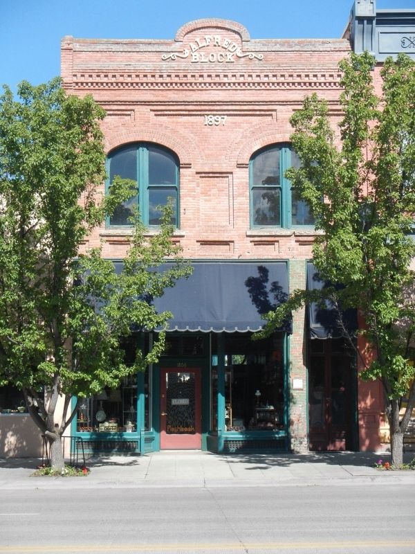
On Main Street (Oregon Route 7) near Valley Avenuee, on the right when traveling north.
Mike Hoff, a “tonsorial artist” (barber) in Baker City in the 1890s, built this building for his business. After a few years, however, Hoff went into partnership with Valentine Bildner to open a saloon in the building.
During the . . . — — Map (db m108060) HM
On Main Street (Oregon Route 7) near Broadway Street, on the right when traveling north.
The Lynndale Building was constructed about 1890. The northernmost of the three first-floor bays was occupied by a saloon from the building's earliest days. The establishment first was named Henry the Fourth, then The Club. Later it became the . . . — — Map (db m108077) HM
On Main Street at Valley Avenuee, on the right when traveling north on Main Street.
The Mann Block, built in 1890, originally housed one of the many saloons located in this block during Baker City’s early, rowdy years. Like most of the establishments, the saloon operated on the first floor, with a bawdy house and gambling rooms . . . — — Map (db m108052) HM
On Resort Street at Broadway Street, on the right when traveling north on Resort Street.
“McCord’s Corner” contributed much to Baker City history.
S. (Syrenus) B. McCord was the first mayor of Baker City. City residents elected him to four terms, and he also served several terms as county treasurer.
In 1873, McCord . . . — — Map (db m108209) HM
On Washington Street near 1st Street, on the right when traveling west.
This building was the location in the 1920s of the Lew Brothers Tire Co., which later moved to Bridge Street. After the tire company relocated, the building was purchased by Glenn Miller, owner of Miller’s Lunch in the adjacent building to the east. . . . — — Map (db m108097) HM
Near Main Street (Oregon Route 7) at Washington Avenue, on the left when traveling north.
This stucco-over-clay block building was constructed in 1923 as a "temporary" structure after a fire destroyed another building on the site. A block store first occupied the building, then an ice cream parlor.
Glenn Miller, a local candy-maker, . . . — — Map (db m108162) HM
On Main Street (Oregon Route 7) near Court Avenueu, on the right when traveling north.
The Mint-Fox Building was constructed as two adjoining structures, the south half in 1888, the north in 1889. The buildings were erected by A.A. Houston, a local builder. Houston first rented the south building to two miners, Lorenzo Durkee and . . . — — Map (db m108061) HM
On Auburn Avenue at Bridge Street, on the right when traveling east on Auburn Avenue.
Dedicated to the memory of the intrepid pioneers who blazed the way over the Old Oregon Trail with the first covered wagons in 1843 and won an empire for the United States.
Erected by the American Legion
July 4, 1925 — — Map (db m108048) HM
On Dewey Avenue (Oregon Route 7) near Auburn Avenue, on the right when traveling north.
The Old Post Office building served as Baker City’s post office for 58 years, from completion of construction in 1910 until 1968, when the Post Office relocated to a new Federal Building a block to the south. The building also housed offices of the . . . — — Map (db m108042) HM
On 1st Street near Washington Avenue, on the right when traveling north.
Baker City at the beginning of the 20th Century was the hub for a vast area of commerce, including mining, agriculture and forest products. Merchandise flowed into the city for distribution to dozens of smaller communities. Likewise, business . . . — — Map (db m108194) HM
Near Oregon Route 86 near Oregon Trail, on the right when traveling west.
Of the 2170 miles of the Oregon Trail, approximately 300 miles of ruts remain. Swales created by thousands of wagon wheels and the trampling of draft animals are deep in some areas, shallow in other places. Much of the trail has disappeared due to . . . — — Map (db m108130) HM
On 1st Street at Court Avenueu, on the left when traveling north on 1st Street.
William Shoemaker, a partner in a Baker City wholesale grocery and grain business, built this building in 1906. Before moving to Baker City, Shoemaker had been in business at Rock Creek, a small community in north Baker Valley. He built and operated . . . — — Map (db m108103) HM
Early Oregon Trail emigrants crested the south flank of Flagstaff Hill and, with the Blue Mountains looming to the west, saw a solitary tree in the valley below. Called l’arbre seul (the lone tree) by French-Canadian fur trappers, this large . . . — — Map (db m108122) HM
On Oregon Route 86 near Oregon Trail, on the right when traveling west.
Beginning in 1843, thousands of Oregon Trail emigrants trekked through this region toward new lives in the West. This epic journey indelibly etched the landscape with wagon ruts, such as those near by. When Henry Griffin, a prospector from . . . — — Map (db m108128) HM
On Main Street (Oregon Route 7) at Church Street, on the left when traveling north on Main Street.
In 1900, after a fire had destroyed a former wood frame hall, the Baker City Masonic Lodge erected a new brick temple.
The lodge hall occupied the second floor. The first floor originally was leased to the E.P. Voruz & Co. Home Furnishing Store . . . — — Map (db m108081) HM
Near Campbell Street near Sunridge Lane, on the right when traveling west.
Wagons and cattle of the Great Migration, led by Marcus Whitman in 1843, descended Sept. 25 into Lone Pine valley.
After nearly a month of travel over the hot dry Snake river plains from Fort Hall near Pocatello, Idaho, the cool climate and lush . . . — — Map (db m108157) HM
This building, constructed in the 1890s, was the location of the Smoke Shop for approximately 50 years. The Smoke Shop was a typical men’s gathering place of the period, offering tobacco, beverages, billiards and card games.
The first business . . . — — Map (db m108035) HM
On 1st Street near Washington Avenue, on the right when traveling north.
Hand-cranked telephones first rang in Baker City in 1889. Not until 1898, however, did a company succeed in establishing 24-hour, central exchange service. When inaugurated, the system had 40 subscribers and one operator on duty.
The first . . . — — Map (db m108195) HM
A moveable community for four to six months along the trail… the wagon encampment typically grouped into a circle, forming a temporary corral. Around the circle, tents and bedrolls provided the shelter for exhausted pioneers. A few guards kept an . . . — — Map (db m199177) HM
On Main Street near Court Avenue, on the left when traveling north.
This property, which consists of parts of two adjacent structures built in the 1880s, was the location of many Baker City businesses over the years. One of the first was Basche-Sage Hardware Co., which was to grow into one of the Northwest’s largest . . . — — Map (db m108039) HM
On Main Street (Oregon Route 7) near Valley Avenuee, on the left when traveling north.
A fire that started in a billiard hall destroyed all the structures on this block in 1886. Several property owners chose to rebuild, and four adjoining brick buildings were constructed the following year. This building was constructed for Messrs. . . . — — Map (db m108050) HM
On Valley Avenue at !st Street, on the left when traveling west on Valley Avenue.
A committee of civic-minded Baker City residents began meeting in 1911 to organize a fund-raising campaign to build a Young Men’s Christian Association building. The committee soon had secured pledges of more than $30,000.
Plans for the . . . — — Map (db m108098) HM
On Old U.S. 30 at Oxman Ranch Road, on the left when traveling west on Old U.S. 30.
This spot was famous in early days as Express Ranch an important relay station on the Umatilla-Boise Basin stage and freight route. It was also a favorite camping place for emigrants and teamsters. — — Map (db m108121) HM
On Forest Road 73, 2.2 miles north of County Road 24, on the right when traveling north.
Center Panel:These Chinese Miners Must Have Felt Like Sysyphus Pushing a Large Rock Uphill Forever, as in Greek Mythology.
The backbreaking labor of stacking and re-stacking sixteen acres of rocks here at the Ah Hee . . . — — Map (db m106776) HM
On Forest Service Road 10 (County Road 24) 0.3 miles south of Federal Road 13, on the right when traveling west.
In the early 1880s, the Red Boy Vein was located and claimed by Daniel Pinson, a Cherokee Indian. The claim did not pan enough free gold to work without a mill. His only legacy is the mine's name.
In 1886 it became a paying proposition when . . . — — Map (db m106767) HM
Natural landforms gave local settlers an opportunity to shape history. As you explore the remains of the gold rush era, consider the partnership of people and nature.
A lake the ice forgot
When the Ice Age glaciers melted, they left . . . — — Map (db m106762) HM
On Front Street (La Grande-Baker Highway) near 4th Street, on the left when traveling north.
Here cattlemen loaded herds into boxcars bound for Portland; while cowboys and rustlers haunted saloons.
Railhead warehouses of the 1880's were town down in the 1990's and with salvaged materials the park project began.
With foresight and . . . — — Map (db m111276) HM
On Interstate 84 at milepost 293 near Medical Springs Highway (Chandler Lane) (Oregon Route 203), on the right when traveling west.
(Six panels dealing with the Baker Valley portion of the Oregon Trail are found beneath this kiosk) Permanent Settlers
In 1861, Henry Griffin, a prospector from California discovered gold eight miles southwest of the present . . . — — Map (db m111284) HM
On Front Street (La Grande-Baker Highway) near 4, on the left when traveling south.
After the close of the Sioux and Piute Indian wars the ranchers of Wyoming and Montana, discouraged in their attempts to fatten the Texas longhorn, turned to Oregon for their cattle. During the spring cattlemen and their cowboys arrived daily from . . . — — Map (db m113516) HM
Near Front Street (La Grande-Baker Highway) near 4th Street, on the left when traveling north.
The first cabin known to have been built in Baker Co. in 1861. Moved from it's original site five miles south in 1993. Disassembled and reconstructed to depict the life of the Oregon Trail Pioneers upon settling in the valley.
Donated to the . . . — — Map (db m111278) HM
Near Oregon Trail Boulevard (Business U.S. 30) near Frontage Road, on the right when traveling north.
The last camp on the weary journey across the Snake River plains. Here the Oregon Trail left the Snake River and wound overland to the Columbia. Here camped Wilson Price Hunt, December 23, 1811; Capt. Bonneville, January 10, 1834; Nathaniel J. . . . — — Map (db m107217) HM
Near Huntington Highway (Business U.S. 30) near Interstate 84, on the right when traveling north.
(The Farewell Bend Oregon Trail kiosk houses seven panels which deal with the trials and tribulations on this arid portion of the Oregon Trail.)
"Pathway to the "Garden of the World"
Excitement filled the air May 22, . . . — — Map (db m107276) HM
On Lockett Road near Vietnam Veterans Memorial Highway (Interstate 84), on the right when traveling south.
From Alkali Springs, called by many pioneers Sulphur Springs, the emigrants traveled on to Birch Creek, which offered much needed water and grass for their livestock. First named "Riviere aux Bouleaux" by French-Canadian fur trappers, here travelers . . . — — Map (db m107212) HM
On Washinton Street East (Business U.S. 30) near 1st Street East, on the right when traveling west.
To reach Oregon, Union Pacific Railroad organized the Oregon Short Line Railway Co. in 1881 and built from Wyoming westward across Idaho in the same year. Oregon Railway & Navigation Co. was building eastward from Portland. Tracks of the two . . . — — Map (db m107282) HM
On Oregon Trail Boulevard (Business U.S. 30) near Frontage Road, on the left when traveling north.
In October 1860 the Van Ornum Party, survivors of the Utter Disaster, reached Farewell Bend. Here they again encountered Indians.
On September 9 & 10, in Idaho, the Elijah P. Utter wagon train suffered a two-day attack by Indians in . . . — — Map (db m107219) HM
On Oregon Trail Boulevard (Business U.S. 30) when traveling north.
By October 1860 the Van Ornum party reached Farewell Bend. They were survivors of the Elijah P. Utter wagon train that was attacked by Indians on September 9 and 10, just west of Castle Butte in Owyhee County, Idaho. The survivors had escaped the . . . — — Map (db m107220) HM
On Washinton Street East (Business U.S. 30) near 1st Street East.
By October 1860 the Van Ornum party reached Farewell Bend. They were survivors of the Elijah P. Utter wagon train that was attacked by Indians on September 9 and 10, just west of Castle Butte in Owyhee County, Idaho. The survivors had escaped the . . . — — Map (db m107292) HM
On Austin Street, 0.1 miles west of Mill Street, on the right when traveling west.
Welcome to the historic world of Sumpter Valley Dredge State Heritage Area! Here you will find one of the largest gold dredges in the United States.
There are many ways to learn about the dredge and the people who worked it, from tours to . . . — — Map (db m106794) HM
Near Austin Street near Mill Street, on the right when traveling south.
As you drove here, you probably saw long rows of rocks all over the valley. These are tailings - topsoil , riverbed rock, and bedrock, left behind by 40 years of dredging.
Because of the dredges' systematic destruction, the original meadow and . . . — — Map (db m111243) HM
The dredge is a huge but simple machine for mining an ancient river bed for gold. It is an expensive, powerful improvement on the shovel and rocker box.
Miners used to call the dredge a "goose"---and for good reason. The dredge is "fed" at the . . . — — Map (db m106890) HM
Near Austin Street near Mill Street (County Route 410), on the right when traveling south.
As you look at the tailings in an aerial photograph or along the road, you'll see that they're played out in neat lines. Why are they straight? Because the dredge had an "anchor" to keep it going forward in a line, rather than wandering over the . . . — — Map (db m111245) HM
The dredge floated in about nine feet of water- but it could move anywhere it wanted in the valley because it took its pond with it.
Hard to imagine, isn't it? It worked because the dredge dug a pond for itself to float in as it moved -- . . . — — Map (db m106871) HM
On Mill Street (County Route 410) near Sumpter Street, on the right when traveling north.
Bank was established in 1899 with a capital stock of $10,000.00. The first officers were A.P. Goss, President and A.H. Goss, Cashier. The bank was destroyed by fire on August 13, 1917 and the vault is all that remains. — — Map (db m111241) HM
On Mill Street at Sumpter Highway (Oregon Route 410), on the right when traveling north on Mill Street.
The bustling boom town of Sumpter stretched from here westward to Powder River at the peak of the mining boom.
The mining camp was named for Fort Sumter, South Carolina, by five ex-Confederate soldiers who discovered gold near here in 1862. . . . — — Map (db m112914) HM
Near Interstate 84 near Gate Road/Sisley Creek Road, on the right when traveling north.
(Six panels dealing with the Burnt River portion of the Oregon Trail are found beneath this kiosk)
Dear Little Willie
Emigration on the Oregon Trail peaked in 1852 with 10,000 would-be Oregonians. Poor sanitation and . . . — — Map (db m108110) HM
Near Camp Adair Road near Pacific Highway West (Oregon Route 99W), on the left when traveling east.
Activated on September 5, 1918 (World War I). Demobilized January 7, 1919. Became Oregon's Reserve Division in 1923. Activated to active duty August 15, 1942 at Camp Adair with orders to be Combat Ready as soon as possible. Trained at Camp Adair, . . . — — Map (db m114386) HM WM
The Quest symbolizes Alice E. Biddle, who in 1870 became the first woman to graduate from what is now Oregon State University. It reflects the energy, dedication and strength of all students in the pursuit of learning. — — Map (db m113343) HM
On SW Avery Park Drive, on the left when traveling east.
(Seven panels dealing with topics related to the Applegate Trail are found at this kiosk.)
Applegate Trail
Southern Route to Oregon
In 1846, Jesse Applegate and fourteen others from near Dallas, Oregon, established a . . . — — Map (db m116846) HM
Built in 1888-89, the Benton County Courthouse is the oldest building in Oregon still being used for its original purpose.
The courthouse was designed by Delos D. Neer, a prominent Portland architect, in a style he described as resembling . . . — — Map (db m107360) HM
On SW Madison Avenue, on the right when traveling west.
The Benton County State Bank building was dedicated on July 25, 1907. The bank, built on the ruins of a burned saloon, was representative of a period of growth and prosperity in Corvallis at the beginning of the 20th century.
Corvallis' . . . — — Map (db m117442) HM
Near Camp Adair Road near Pacific Highway West (Oregon Route 99W), on the left when traveling east.
The US War Department ultimately selected 55,000 acres at this location for an infantry training site in 1941. Temporary quarters were constructed, and the site was dedicated as Camp Adair in 1942. Camp Adair was designed to train two divisions at . . . — — Map (db m114382) HM
On Southwest Madison Avenue at Pacific Hwy W (U.S. 20), on the right when traveling east on Southwest Madison Avenue.
The Corvallis City Hall was located on the southeast corner of Fourth and Madison Streets from 1892 to 1956. This grand brick and stone building with the imposing belltower housed the City Council Chambers, and in addition, provided much of the . . . — — Map (db m112916) HM
On SW 1st Street north of SW Jefferson Avenue, on the right when traveling north.
The banks of the Willamette River were the focus of early town development. The town plat for Marysville was files on February on February 25, 1851, by Joseph C. Avery, using a portion of his land claim of 1845. The town included property from the . . . — — Map (db m117488) HM
On SW Campus Way, 0.5 miles west of SW 35th Street, on the left when traveling west.
The Reach
The Agricultural Reach of Oak Creek drains the croplands and research farm facilities of OSU. The Department of Animal Science manages these agricultural lands. Pastures are used for seasonal grazing and production of hay and . . . — — Map (db m108388) HM
The Episcopal Diocese of Oregon established the first school in the Central Park area. Dr. William Graham, a local physician, donated four lots on the block bounded by Madison, Monroe, Seventh, and Eighth Streets. He stipulated that the building . . . — — Map (db m117365) HM
On SW 8th St at SW Madison Ave, on the right when traveling north on SW 8th St.
The First Congregational Church was built here in 1917 to serve a congregation that had outgrown its original 1889 building at Third and Jefferson streets. Designed by architect Roy Dobell, a former instructor at Oregon Agricultural College (OAC, . . . — — Map (db m117268) HM
On SW Madison Ave at SW 8th St, on the right when traveling west on SW Madison Ave.
Fred J. Porter was the great-grandson of Benton County pioneer, Johnson Mulkey.
In the winter of 1845, Mulkey filed a land claim for 640 acres along Oak Creek, on the north side of Baldy Mountain. This was only a few months after Joseph Conant . . . — — Map (db m117266) HM
On Southwest Monroe Avenue, on the left when traveling west.
Mechanical Hall
This structure was built in 1899 to replace the original Mechanical Hall that burned to the ground on September 27, 1898. That fire threw the school year into chaos, since the building had housed the entire engineering program . . . — — Map (db m112864) HM
This is one of the first mill stones or burns to be used in this section of Oregon. This was originally quarried in France and shipped around the horn from New York in 1850 by sailing vessel. In 1852, was transported by oxen team from Portland to . . . — — Map (db m116840) HM
On Southwest Madison Avenue at SW 2nd St, on the left when traveling east on Southwest Madison Avenue.
The L.G. Kline Building was built in 1889 for Lewis G. Kline after his successful career as a dry goods merchant in Corvallis.
Kline, a Polish immigrant, came to Corvallis with his wife, Adaline, a Russian immigrant, in 1864. The Klines and . . . — — Map (db m112915) HM
On SW Madison Ave, on the left when traveling north.
In 1973, Dr. Robert MacVicar, president of Oregon State University, and Gene Hansen, president of the Corvallis Chamber of Commerce, discusses the need to develop a stronger connection between the university and downtown, especially for . . . — — Map (db m117364) HM
On SW Campus Way, 0.5 miles west of SW 35th Street, on the left when traveling west.
A Watershed
A watershed is an area of land from which water drains and flows into a river and its tributaries. Small watersheds, such as Oak Creek’s, become part of larger watersheds when their streams converge. Thus, Oak Creek‘s . . . — — Map (db m108389) HM
On SW Jefferson Way at SW 15th Street, on the right when traveling west on SW Jefferson Way.
On October 27, 1868, the small institution of higher education known as Corvallis College was granted a charter by Oregon's legislative assembly designating it as the state's land grant institution under the provisions of the federal 1862 Morrill . . . — — Map (db m108382) HM
World War I plaque
In Memory of
Earl Blackden
Owen Johnson
R K Wilmot
Foresters Who
Fell in the
World War
1917-1918
World War II plaque
In Memory Of O. S. C.
Foresters
Who Lost Their Lives
In World War II . . . — — Map (db m113266) WM
On SW 1st Street north of SW Jefferson Avenue, on the right when traveling north.
The first steamboat to reach Corvallis was the sidewheeler Canemah in October of 1851. With this arrival, Corvallis joined Oregon's steamboat era, with tis stories of risk, profit, rivalries, mergers, heroics, innovation and disasters. . . . — — Map (db m117465) HM
Site of the earliest boat landing Lower Town, Marysville, 1851 Presented to City of Corvallis, Oregon Centennial Celebration, June 1957 by the Winema Chapter Daughters of the American Revolution — — Map (db m107333) HM
On SW Campus Way, 0.5 miles west of SW 35th Street, on the left when traveling west.
Agricultural Users
This portion of the Oak Creek watershed is managed as a working agricultural laboratory. Agricultural users include the OSU Dairy Center, beef and sheep production barns, and the Veterinary Medicine Research Farm . . . — — Map (db m108387) HM
On SW Madison Ave, on the left when traveling north.
The Corvallis Arts Center building began its life as an Episcopal church, constructed in in 1889 just a block south of here. It was one of the products of the influential English emigrants who arrived in Benton County in the late 1800s under the . . . — — Map (db m117279) HM
Ferry service across the Willamette River was established by William F. Dixon, co-founder of Corvallis, in 1848. The service continued for 65 years until the opening of the Van Buren Street Bridge in 1913.
In the 1860s, the ferry was operated . . . — — Map (db m117447) HM
On SW Washington Avenue at SW 8th Street, on the right when traveling east on SW Washington Avenue.
The Incubator House and Poultry Building stood at 26th and Jefferson on the OAC (Oregon Agricultural College, now OSU) campus until 1927, where they formed the headquarters of the Department of Poultry Husbandry.
The Incubator House was the . . . — — Map (db m117612) HM
On Pacific Highway West at Pacific Hwy W (U.S. 20) on Pacific Highway West.
The Opera House was built on this site in 1870. It was a wooden building with a porch and covered entrance which faced on Fourth Street. The residents of Corvallis raised the money by subscription and donated their labor to build it. Inside there . . . — — Map (db m112917) HM
On Camp Adair Road near Pacific Highway West (Oregon Route 99W).
The 104th Infantry Division was activated on 15 September 1942, at Camp Adair and was named "The Timberwolves." After 18 months of training at Camp Adair and maneuvers in Eastern Oregon and the California-Arizona desert, they moved to Camp Carson, . . . — — Map (db m114384) HM WM
Near Camp Adair Road near Pacific Highway West (Oregon Route 99W), on the left when traveling east.
The 70th Infantry Division was activated on 15 June 1943 as "Oregon's Own" and was named "The Trailblazers" in honor of the Oregon Trail Centennial. After a year of training here at Camp Adair the Division moved to Ft. Leonard Wood, Missouri for . . . — — Map (db m114383) HM WM
Near NE 1st Street south of NW Harrison Boulevard.
The Van Buren Street Bridge is Oregon's only remaining example of a movable bridge built using the rare pin-connected truss technology. The use of pins, or bolts, connecting each truss point allowed the bridge to be easily assembled on site after . . . — — Map (db m117491) HM
On Pacific Hwy W (U.S. 99) at SW Madison Ave, on the right when traveling north on Pacific Hwy W.
The Whiteside Theatre opened on November 9, 1922. That evening, the audience enjoyed the silent picture “The Old Homestead,” accompanied by Lilian McElroy on a $20,000 two manual, double touch Wurlitzer organ. That organ was the largest, and the . . . — — Map (db m117434) HM
Near Camp Adair Road near Pacific Highway West (Oregon Route 99W), on the left when traveling east.
The 91st Infantry Division was originally activated 5 September 1917 at Camp Lewis, Washington and designated the "Wild West Division." The battle cry "Powder River! Let'er Buck!" was adopted in 1918. During World War I the division fought in the . . . — — Map (db m114385) HM WM
In June 1846 Jesse Applegate, Levi Smith and 11 other men left their homes near Dallas Oregon to develop a southern route from Fort Hall (Idaho) to the Willamette Valley. Their route passed through the gap west of Pigeon Butte, then proceeded . . . — — Map (db m119068) HM
On Bellfountain Rd, on the left when traveling south.
On this knoll stood Ebenezer School-
house, built in 1850. The first school
in the historic Belknap settlement, it was
also used for Methodist Sunday school
and class meetings.
In 1854, the second Methodist Conference
on the West . . . — — Map (db m119276) HM
On Pacific Hwy (U.S. 99) at Main Street, on the right when traveling south on Pacific Hwy.
(Two interpretive displays are located here next to the South Benton Community Museum):
(First Display)
In 1846, Jesse Applegate and fourteen others from near Dallas, Oregon, established a trail south from the Willamette Valley and . . . — — Map (db m116837) HM
1189 entries matched your criteria. The first 100 are listed above. Next 100 ⊳