English:
During the first half of the 19th century maritime officials took steps to reduce the many navigational risks and shipwrecks along the eastern seaboard of Canada. One of the new lighthouses put up was at Louisbourg, in 1842. It . . . — — Map (db m79965) HM
Three panels are located at this site.
Chabert’s Mission / La mission du marquis de Chabert
English:
In 1750 the Marquis de Chabert, a French astronomer, was commissioned to go to North America to correct the maps of . . . — — Map (db m142944) HM
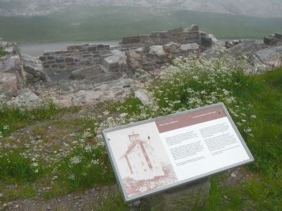
English:
Here are the ruins of Louisbourg’s first light, the earliest to be erected in Canada and the second in North America. Lit in 1734, it was badly damaged in a fire two years later, then quickly repaired. The replacement lantern was . . . — — Map (db m142960) HM
English:
On this site was erected by France, in 1731, the first Lighthouse Tower, constructed of fireproof materials, in North America.
Near here the British erected batteries to silence the defensive works erected by France. In 1745, . . . — — Map (db m79967) HM
English:
These are the remains of a two and a half storey masonry house built in the late 1730s for merchant and militia captain Julien Fizel and his wife Françoise Tetard.
The house served several purposes: the basement was used as . . . — — Map (db m142961) HM
English:
In 1713, France decided to found Louisbourg to defend her colonial and maritime interests in North America. As capital of the colony of Isle Royale and guardian the Gulf of Saint. Lawrence, it became the most important French . . . — — Map (db m79915) HM
English:
This tablet commemorated the valour and endurance displayed against overwhelming odds, by the French forces, who, in 1745 and again in 1758, garrisoned the defensive batteries on the Island opposite the entrance to the harbour of . . . — — Map (db m79968) HM
French Naval Guns raised
by the Dominion Coal Company in 1895
from the bottom of Louisburg Harbour
and mounted at the Louisburg Railroad Station
presented to the Fortress of Louisburg
National Historic Site
by the
Dominion Steel . . . — — Map (db m142962) HM
English:
This point of land is named after Capt. D.J. Kennelly (ca. 1831-1907), who had a house near here during the late 19th century. An Irish-born industrialist who came to Cape Breton during the 1870s, Kennelly was captivated by . . . — — Map (db m142963) HM
English:
During the 1745 and 1758 sieges the attackers built artillery batteries on Lighthouse Point to silence the Island Battery. This would have allowed warships to enter the harbour for a combined land and sea assault on the town. The . . . — — Map (db m142964) HM
English:
Louisbourg’s destiny has been largely shaped by its harbour. Well-protected, relatively deep and close to the fishing banks, it was the harbour that attracted the French to settle here in the 1700s. In the 19th century ice-free . . . — — Map (db m79963) HM
English:
Captured in Africa at the age of 19 and transported to Ile Royale, where she was sold to a member of the colonial elite, Marie Marguerite Rose is seen to be a key figure of the initial phase of Black slavery in Canada. Gaining her . . . — — Map (db m79917) HM
Two panels make up this marker
Slavery / Esclavage
English:
Marie Marguerite Rose was the name given to a young woman captured in Guinea, Africa, sold to French traders and brought to Louisbourg in 1736 as a slave for . . . — — Map (db m79918) HM
Cape Breton’s mining industry dictated the need of an outlet in Louisbourg to link the various railways around Sydney with Louisbourg’s ice-free harbour, allowing for year-round shipping of coal. The first attempt in 1873 was a narrow, poorly . . . — — Map (db m142965) HM
English: Between 15 May and 15 July the ocean in front of you is dotted with the buoys of the lobster fishery. The Mi’kmaq as well as the French and the English ate lobster and other shellfish during the 18th Century. During the 1754 siege . . . — — Map (db m79941) HM
English: In both sieges the attackers made their initial landings in this cove. In 1745 the French defended the cove with only a small detachment but in 1757 they built and garrisoned extensive fieldworks here. The following year . . . — — Map (db m142966) HM
English: Here, 8th June, 1758, the men of Brigadier General James Wolfe’s brigade, after having been repulsed with heavy loss by the French troops entrenched westward made their gallant and successful landing.
Thus began the operation . . . — — Map (db m79938) HM