The Rideau Canal is a 202 kilometre waterway made navigable by a system of more than 50 dams, 47 locks and 19 kilometres of actual canal ruts. Built between 1826 and 1832 as British military defence strategy, the Canal served as a . . . — — Map (db m112342) HM
In these times of rapid change and technological advancement, few things in life remain constant. However, Dickinson Square has endured over the years by serving its community through diversification, resilience and sheer . . . — — Map (db m112362) HM
From the beginnings of flight, our aviators have served with courage and skill, high in the skies, in defence of freedom in all corners of the World.
Clouds over which our aviators fly and colours of the fields below are conveyed by these . . . — — Map (db m110340) WM
Backed by proud tradition, our soldiers guard our homeland and bravely serve at great costs to resist aggression and protect liberty in many lands.
Red poppies symbolize their sacrifice, complemented by the many blue oceans they cross.
Fiers . . . — — Map (db m110351) WM
Used to support Milling operations, the Carriage Shed, allowed farmers to rest their horses, while they waited for their grain to be milled or feed to be mixed. It was also used to stored [sic] and sell products, such as carriages made . . . — — Map (db m110299) HM
Pictured in 1870, Dickinson House was originally built by American born Moss Kent Dickinson for his business and was modelled after Abraham Lincoln's house in Springfield, Illinois. The house ultimately became home to the Dickinson, . . . — — Map (db m110309) HM
You are standing in Dickinson Square, named after Moss Kent Dickinson, the founder of the Village of Manotick. Dickinson and his partners were established forwarders of goods and people along the Rideau River. Recognizing the potential . . . — — Map (db m112355) HM
Since the late 1800s Dickinson Square has influenced the development of Manotick, the Ottawa region and beyond. It steadfastly remains one of the last industry-based village squares in Ontario. Over the past 150 years the Dickinson, . . . — — Map (db m110311) HM
In national crises, people across our land unite in determination and effort to boost production and morale, vital to our cause.
These plants portray a patchwork of communities and farms across the country.
En temps de crise nationale, les gens . . . — — Map (db m110335) WM
This is a place to remember and to reflect with gratitude on the contributions made by those who served their country in war and peace.
The park contains six floral gardens dedicated to the Army, Navy, Air Force, Merchant Navy, Peacekeeping under . . . — — Map (db m110319) WM
In wartime, merchant mariners have collectively faced constant danger and heavy losses to carry vital supplies and personnel across the oceans.
These plants depict the many crossings of our mariners, with yellow symbolizing the hope of our . . . — — Map (db m110332) WM
On the high seas, our sailors defend our sovereignty, protect sea lanes and support our troops, ever ready to heed the call of far flung allies.
Ship bells and white foam of ocean wavers are illustrated here.
En haute mer, nos marins défendent . . . — — Map (db m110346) WM
Our peacekeepers in blue berets have won international respect and Canadian pride in serving with the United Nations to resolve strife and promote democracy.
Canadian native plants are combined with many other named for lands of our major . . . — — Map (db m110327) WM
This Park is located on the former site of the Clapp Family Barns. Note the remnants of the barn foundation around this sign. The barn complex, shown here, is in front of the old bridge whose abutment remains behind the Cenotaph.
Johnston Clapp . . . — — Map (db m110356) HM
An outstanding example of mill architecture in Ontario, this grist-mill was constructed by Thomas Langrell, an Ottawa contractor, for Moss K. Dickinson (1822-97) and Joseph M. Currier (1820-84), the owners of a nearby sawmill. The Long Island Mill . . . — — Map (db m110294) HM
After the War of 1812 between Britain and the United States, many citizens of Upper and Lower Canada feared Americans had unfinished business with Canada. As a result, the Rideau Canal was constructed as part of a military system to . . . — — Map (db m110301) HM
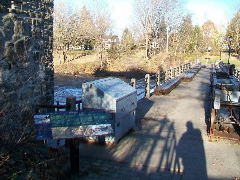
Since the Rideau Canal opened in 1832, water management has been essential to its successful operation. Initially, water concerns focused on maintaining navigation and protecting engineering structures, with the excess water supplied to . . . — — Map (db m112353) HM
In memory of those men
and women of the Canadian and
Allied Forces, who made the
supreme sacrifice for
their country, in times of war,
peace or peacekeeping.
WE WILL REMEMBER THEM — — Map (db m110318) WM