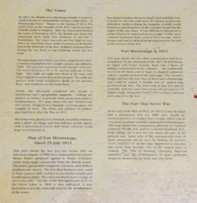
The Tower
By 1813, the British were planning to build "a tower in small redoubt to command the entrance of the River...at Mississauga Point." Begun in the Spring of 1814, this tower rests on the remains of the first Capital of . . . — — Map (db m52200) HM
A Strategic Location
You are standing at Mississauga Point where the Niagara River flows into Lake Ontario. Long ago the lakes and rivers were military supply and transportation routes and forts were built to protect them. . . . — — Map (db m52610) HM
Near Queens Parade just south of Wellington Street..
Fort Niagara was only 1200 metres from Fort George, well within artillery range. In May, 1813, combined artillery fire from Fort Niagara, its detached batteries, and American warships at the river's mouth completely destroyed Fort George and forced . . . — — Map (db m53604) HM
Near Queens Parade, on the right when traveling north.
The Niagara River was extremely important from a strategic perspective. It was part of the St. Lawrence – Great Lakes system, one of the main transportation routes on either side of the border. Those who controlled the waterways would . . . — — Map (db m140087) HM
On Butler Street west of John Street West when traveling west.
On the 8th of July, 1813, an outpost of the invading force, encamped near Fort George, was defeated by a band of Six Nations and Western Indians led by Chiefs John Norton and Blackbird and interpreters Michel Brisebois, Louis Langlade and Barnet . . . — — Map (db m48747) HM
Near King Street, on the right when traveling north.
This plaque, erected by the Legislative Assembly of Ontario, commemorates the Bicentennial of the first Parliament of Upper Canada held at Newark (Niagara-on-the-Lake) near this site on September 17th, 1792, which marked the beginning of . . . — — Map (db m140020) HM
On Niagara Parkway north of Brown's Point Circle, on the left when traveling south.
Brown's Inn was located here. Both the Canadian York Militia and the American Army bivouacked near here on separate occasions during the War of 1812. Adam Brown later added a store to his inn, and built a wharf on the river shore below, where . . . — — Map (db m49166) HM
On Byron Street at Melville Street, on the right when traveling west on Byron Street.
In 1777 John Butler of New York raised a force of Rangers who, with their Iroquois allies, raided the frontiers of New York, Pennsylvania and New Jersey throughout the American Revolutionary War. From their base at Fort Niagara they successfully . . . — — Map (db m75857) HM
On Niagara Parkway east of East West Line (County Route 85), on the right when traveling north.
In the early morning of December 19th, 1813, a force under Colonel John Murray, consisting of detachments of the 100th and 41st Regiments. Royal Scots, Royal Artillery and Canadian Militia embarked in bateaux at the foot of this ravine. Crossing . . . — — Map (db m49158) HM
On Niagara Parkway just north of York Road (County Route 81), on the right when traveling north.
On March 14, 1793 Chloe Cooley, an enslaved Black woman in Queenston, was bound, thrown in a boat and sold across the river to a new owner in the United States. Her screams and violent resistance were brought to the attention of Lieutenant Governor . . . — — Map (db m75858) HM
Near King Street, on the right when traveling north.
The first session of the Legislative Assembly held at Newark (Niagara-on-the-Lake) from 17 September to 15 October 1792, introduced a limited form of representative government to the newly created colony of Upper Canada. The elected assembly formed . . . — — Map (db m140021) HM
Constructed by order of Lieutenant-Governor Simcoe 1796-99, Fort George served as the headquarters for Major-General Brock in 1812. In May, 1813, it was bombarded and captured by the Americans who constructed fortifications of their own on the site. . . . — — Map (db m48743) HM
Near Simcoe Street north of Front Street, on the left when traveling east.
This tower and earthwork are all that survive of the barracks, guardroom, and cells of Fort Mississauga. Built between 1814 and 1816 to replace Fort George as the counterpoise to the American Fort Niagara immediately opposite, it was garrisoned . . . — — Map (db m48745) HM
Near Simcoe Street just north of Front Street when traveling north.
• Mississauga Point was the location of a Neutral First Nation fishing settlement by the 15th century.
• The area was under the control of the Seneca Nation during the late 17th century, and it became home to the Mississauga Nation by the . . . — — Map (db m52236) HM
On Simcoe Street at Front Street, on the left when traveling east on Simcoe Street.
Explore a part of our heritage - visit a fort almost 200 years old and discover part of the Lake Ontario shoreline.
Explorez un volet de notre patrimoine - visitez un fort qui a presque 200 ans d'histoire et decouvrez une partie du rivage du . . . — — Map (db m48632) HM
Near Queens Parade just south of Wellington Street.
Across the Niagara River is the imposing American stronghold, Fort Niagara. Originally built by the French, then occupied by the British, and finally by the Americans, this fort for nearly 150 years stood guard over the traditional supply route to . . . — — Map (db m53630) HM
Near Queens Parade, on the right when traveling north.
Only 1200 metres across the Niagara River is the imposing American stronghold, Fort Niagara. Originally built by the French, then occupied by the British, and finally the Americans, this fort for nearly 150 years stood guard over the traditional . . . — — Map (db m140089) HM
Near Queen's Parade just south of Wellington Street.
Garrison guns were heavy and awkward to move. To be transported, the barrel had to be taken off the carriage with the help of a tripod hoist or gun gin. The gin was equipped with a pulley system that made it possible for two men to lift the barrel. . . . — — Map (db m54006) HM
On Castlereagh Street just west of Davy Street, on the right when traveling west.
For more than thirty years Janet Carnochan, a native of Stamford, Ontario, taught elementary and secondary school at Niagara-on-the Lake, but she made her greatest contribution to the community as a historian rather than as an educator. A . . . — — Map (db m75859) HM
On Ricardo Street just south of Melville Street, on the left when traveling south.
Here at Niagara on September 17, 1792
he presided over the first
representative assembly
of this province.
His genius foresaw the greatness of
this country and he threw himself
into its building with ardour and
enthusiasm. . . . — — Map (db m49475) HM
On Ricardo Street just south of Nelson Street, on the right when traveling north.
Simcoe was born in Northamptonshire and educated at Oxford. He joined the British army in 1771, and from 1777-81 commanded the Queen's Rangers, a Loyalist corps in America. After the Loyalist influx had led to the creation of a separate province of . . . — — Map (db m75860) HM
On King Street, on the right when traveling north.
With the generous support of the Ministry of Canadian Heritage, the Town of Niagara-on-the-Lake Heritage Fund and the Henry N.R. Jackson Foundation.
Sculptor Roy Charles Asplin Unveiled July 1999 — — Map (db m140011) HM
On Niagara Parkway south of Line Road 2, on the right when traveling north.
Soldier, politician, diplomatist and colonizer, de Puisaye was born at Mortagne-en-Perche, France, about 1755 and enlisted in the French Army at 18. Elected to the States General in 1789, he supported reform but, alarmed by the course of the . . . — — Map (db m49159) HM
On Ricardo Street just south of Melville Street, on the left when traveling south.
[Text on Marker]:
Immediately after the War of 1812, a new wooden storehouse was built on this site. It was converted into barracks for British troops during the border troubles of 1838. The building remained in use until the 20th . . . — — Map (db m49478) HM
On Butler Street west of John Street West when traveling west.
Born in New London, Connecticut, Butler settled in the Mohawk Valley, New York, in 1742. Commissioned in the British Indian Department in 1755, he served in the Seven Years War. At the outbreak of the American Revolution , he was compelled to leave . . . — — Map (db m49165) HM
On River Beach Drive at Turntable Way, on the left when traveling north on River Beach Drive.
For 103 years, beginning in 1854, a train powered by a steam locomotive pulled into the Niagara Dock. At first it only came from Chippawa via Niagara Falls and Queenston but by 1863 the line had been extended as far as Fort Erie and Buffalo. The . . . — — Map (db m54079) HM
On Niagara Parkway just south of East West Line (County Route 85), on the left when traveling south.
This Georgian style house was built in 1800 by John McFarland (1757-1815) and his sons, on land granted by the Crown. It is one of the oldest surviving structures in the Niagara district. During the War of 1812 it was used as a hospital by both . . . — — Map (db m49480) HM
On Castlereagh Street just west of Davy Street, on the right when traveling west.
This building, the first in Ontario to be constructed for use solely as an historical museum, was begun in 1906 and completed the following year. Its erection was due largely to the dedicated efforts of Miss Janet Carnochan, founder, and for thirty . . . — — Map (db m75861) HM
On Ricardo Street just south of Melville Street, on the left when traveling south.
The facilities of this strategic location have served British and later Canadian troops stationed at Niagara from 1765 to the 1920's. — — Map (db m49477) HM
On Mississagua Street just north of John Street West, on the right when traveling east.
Here stood a Baptist church erected in 1830 through the exertions of a former British soldier. John Oakley, who although white, became pastor of a predominantly negro congregation. In 1793 Upper Canada had passed an act forbidding further . . . — — Map (db m75862) HM
On King Street at Picton Street, on the right when traveling north on King Street.
The first organization devoted to the improvement of agriculture in Ontario was founded at Niagara. Its original name, the Agricultural Society of Upper Canada, reflected Lieutenant-Governor John Graves Simcoe’s hope that it would become a . . . — — Map (db m139985) HM
On Queen Street at King Street, on the right when traveling south on Queen Street.
Acquired by the Ontario Heritage Foundation in 1969, the Niagara Apothecary is a fine example of a Confederation era commercial establishment and pharmacy. Although the building probably dates to the 1820's. It was extensively renovated in 1866 when . . . — — Map (db m24609) HM
On Queen Street, 0.08 kilometers east of Regent Street, on the right when traveling east.
[English] This is the third and only surviving court house erected for the former Niagara District. Constructed between 1846 and 1848, it was designed by the prominent Toronto architect, William Thomas, in the fashionable Neoclassical style . . . — — Map (db m196309) HM
On Ricardo Street just east of Melville Street, on the right when traveling south.
Formed by local businessmen in 1831, the Niagara Harbour and Dock Company created a shipping basin here on the Niagara River by hiring hundreds of labourers to excavate a riverside marsh. By the late 1830s the company employed close to 400 workers . . . — — Map (db m54049) HM
On King Street, on the right when traveling north.
On December 12th, 1895, a group of dedicated persons founded the Niagara Historical Society. This tree was planted in 1995 to commemorate the 100th Anniversary of the Society. — — Map (db m140025) HM
On Castlereagh Street just west of Davy Street, on the right when traveling west.
To obtain land on which to settle Loyalists and dispossessed members of the Six Nations of the Iroquois, Guy Johnson in May 1781 and John Butler in May 1784 negotiated treaties with representatives of the Mississauga and Chippewa of this region. The . . . — — Map (db m75863) HM
Brock's Monument and
Queenston Heights:
This striking commemoration and final resting place of Major General Brock marks the site of the Battle of Queenston Heights. Visitors can climb the 235 stairs to take in spectacular views, or . . . — — Map (db m54037) HM
(Left side is in English)
In 1778, Loyalist refugees began crossing from Fort Niagara to settle the west bank of the Niagara River. A town was laid out in a grid pattern of four-acre blocks and grew quickly, gaining prominence as the first . . . — — Map (db m24585) HM
The first lighthouse on the Great Lakes was built of stone at Point Mississauga in 1804 by John Symington, under orders from Lieutenant-Governor Peter Hunter. Demolished in 1814 to make room for this fort, its materials with debris from the ruined . . . — — Map (db m48746) HM
On Byron Street, on the right when traveling south.
This burial plot commemorates the Polish soldiers who trained in this community from 1917 – 1919 at Camp Kosciuszko and subsequently made the supreme sacrifice – They personified the Polish soldiers’ motto: “For Your Freedom and . . . — — Map (db m140019) HM
Near Queen's Parade just south of Wellington Street.
Field artillery was designed for mobility. Cannons mounted on carriages with large wheels could be moved quickly, even over rough terrain. This six pounder has a limber to carry ammunition and supplies and would be harnessed to a team of horses. . . . — — Map (db m54000) HM
On Portage Road (Local Route 61) at the Niagara Parkway Roundabout, on the right when traveling west on Portage Road.
This cairn marks the southern terminus of the Bruce Trail, a cross-country foot trail established along or adjacent to the Niagara Escarpment extending from Tobermory on Georgian Bay in the north to this southern terminus at Queenston Heights.
. . . — — Map (db m79046) HM
On Byron Street, on the right when traveling west.
One of the earliest Anglican churches in the province, St. Mark’s was begun in 1804 to serve a congregation organized twelve years earlier. Its first rector, the Reverend Robert Addison, chaplain of Upper Canada’s first Legislative Assembly, . . . — — Map (db m139894) HM
On Picton Street at Wellington Street, on the left on Picton Street.
The Parish of St. Vincent de Paul is the direct successor of the many and often interrupted endeavors in the Niagara area since 1626. At first concerned with native peoples, later French and then English-speaking priests came as chaplains for the . . . — — Map (db m37237) HM
On Queen Street north of Newark Street, on the right when traveling north.
On the 25th May, 1813, the American Fleet and the Batteries at Fort Niagara across the river began a devastating two-day bombardment of Fort George. On the 27th a large American force was landed and after a brief engagement in which his outnumbered . . . — — Map (db m48628) HM
Near Queens Parade, on the right when traveling north.
In May of 1813, combined artillery fire from Fort Niagara and detached batteries destroyed Fort George paving the way for invasion. On May 27th, a large American force defeated a much smaller number of British regulars, militia and First Nations . . . — — Map (db m140092) HM
On York Road (County Route 81) at Four Mile Creek, on the left when traveling east on York Road.
On July 18th, 1814, during the final American campaign on the Niagara frontier, Major-General Peter B. Porter sent a detachment of militia from the United States encampment at Queenston to attack St. Davids. This force, commanded by . . . — — Map (db m58172) HM
On Castlereagh Street just west of Davy Street, on the right when traveling west.
On July 20, 1799, the first edition of the "Canada Constellation", Upper Canada's earliest independent newspaper, was published at Niagara by Gideon and Silvester Tiffany, two brothers who had come from the United States. Gideon had at first held . . . — — Map (db m75864) HM
On Ricardo Street just south of Melville Street, on the left when traveling south.
[Text on Marker]:
Navy Hall originally consisted of a small shipyard, storehouses, residences and docks which served as a depot for local supplies; it also served as a trans-shipment point for the posts on the upper Great Lakes. From . . . — — Map (db m49476) HM
On Niagara Parkway south of 4 Line Unopened Road, on the right when traveling south.
One of the oldest brick houses in Ontario, this handsome Georgian structure was built about 1800. Originally a farm house, it was the home of Gilbert Field (1765-1815), a United Empire Loyalist who was in possesion of the land by 1790. During the . . . — — Map (db m56718) HM
On King Street at Byron Street, on the right when traveling north on King Street.
On September 17, 1792, Colonel John Graves Simcoe, Lieutenant-Governor of Upper Canada, opened in this community, then the capital, the first provincial parliament. The legislature consisted of an appointed Legislative Council and an elected . . . — — Map (db m139893) HM
Near Queens Parade just south of Wellington Street.
The St.Lawrence and Great Lakes system was the most efficient route to the interior of the continent of North America. Large waterways allowed for substantial sailing vessels to trade and maintain contact with Native allies from Montreal to the . . . — — Map (db m53624) HM
On Mississagua Street just north of John Street West, on the right when traveling east.
Inspired by the abolitionist sentiment emerging in the late 18th century, Lieutenant-Governor J.G. Simcoe made Upper Canada the first British territory to legislate against slavery, which had defined the conditions of life for most people of African . . . — — Map (db m75865) HM
On Niagara Parkway just north of Line 1 Road, on the left when traveling south.
One of Ireland's best loved and renowned poets and lyricists, Thomas Moore visited Niagara during July 1804. Captivated by the scenic splendour of the area and as guest of Col. Isaac Brock, Commander at Fort George, Moore frequently found rest and . . . — — Map (db m49481) HM
On King Street at Picton Street, on the right when traveling north on King Street.
Known at various times as Butlersburg, West Niagara and Newark, its first permanent settlers, including Butler’s Rangers and other Loyalists, arrived about 1780. The first five sessions of Upper Canada’s legislature met here under . . . — — Map (db m139988) HM
On Niagara River Parkway at Queenston Street, on the right when traveling north on Niagara River Parkway.
This monument was erected in memory of the men of Niagara Township who gave their lives for the cause of freedom in the Great War 1914 – 1918 And in World War II 1939 – 1945 Whose names are here recorded and in honour of those who . . . — — Map (db m140123) WM
Near Queen's Parade just south of Wellington Street.
Everywhere
Artillery was vitally important to the defense of Upper Canada. Due to a shortage of heavy cannons available in the province, there were only five garrison guns mounted inside Fort George in May of 1813. . . . — — Map (db m53989) HM
Near King Street, on the right when traveling north.
Ontario’s first newspaper, Upper Canada Gazette, or American Oracle was published in Niagara-on-the-Lake by Louis Roy, King’s Printer to John Graves Simcoe, founding Lieutenant Governor of Upper Canada. The first edition of four pages . . . — — Map (db m140013) HM
On Niagara Parkway north of Line 8 Road, on the right when traveling north.
Manned by Captain Samuel Hatt's 5th Lincoln (Militia) Regiment and a small party of the Lincoln Militia Artillery under Lieutenant John Ball, and consisting of one 24-pounder cannon mounted within a crescent-shaped earthwork, this Battery was . . . — — Map (db m48750) HM
Near Queens Parade just south of Wellington Street.
Built in 1796, Fort George was the scene of fierce engagements during the War of 1812. It was captured and destroyed then refortified by the Americans in 1813. It was re-taken by the British later that same year. The fort was abandoned in the . . . — — Map (db m54038) HM
On Queen Street, 0.05 kilometers north of King Street.
In English:
Born in England, Kirby came to Canada in 1839 and began work as a tanner in the vicinity of Niagara-on-the-Lake. There he developed his literary talents and soon after moving into the town in 1848 embarked on a long and . . . — — Map (db m34915) HM