During the First World War, Victoria was unprepared to fend off air attacks. In 1921, the 2nd AA (Anti-Aircraft) battery was formed in Victoria. No AA guns existed in Canada, so the unit made do with 13-pounder guns on a locally improvised . . . — — Map (db m98996) HM
On Oak Bay Avenue at Hampshire Road, on the left when traveling east on Oak Bay Avenue.
The Burrell family home, "Summerdyne", on Oak Bay Avenue at Monterey looking west - circa 1906
The Burrell family walking east along Oak Bay Avenue near their home - circa 1900 — — Map (db m75299) HM
Through arctic cold, desert heat, or jungle humidity, the rugged reliability of this no-frills "Vehicle, General Purpose" (G.P.) made it the most successful and recognizable Allied vehicle of the Second World War. Between 1939 and 1945 more . . . — — Map (db m99346) HM
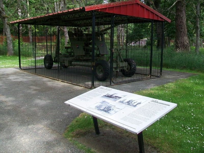
During the 1950s this type of anti-aircraft gun was part of the Victoria-Esquimalt defences, although it was not used here at Fort Rodd Hill.
This American-made weapon had begun to replace the British-designed 3.7-inch gun as the Canadian . . . — — Map (db m75031) HM
This building was constructed in about 1900 to served as a canteen where the off-duty soldier could make purchases from a limited stock, drink beer and relax.
The building was used as a canteen during summer training periods at Fort Rodd . . . — — Map (db m98860) HM
After two historic voyages of the South Pacific[,] Cook was cruising the waters of the Pacific Northwest on his third and final voyage, with his two ships, Resolution and Discovery[.] He was searching for the western exit to the legendary Northwest . . . — — Map (db m48546) HM
Before 1903 the remains of early Chinese immigrants were buried in the low-lying, southwestern corner of Ross Bay cemetery. This area was often flooded after a heavy rainstorm. In the early 1900s, high winds and waves eroded a few waterfront . . . — — Map (db m75449) HM
The harbours at Victoria and Esquimalt, and the adjacent coastline were defended by temporary gun emplacements from 1878. International crises during the latter part of the century led to an agreement between the Canadian and British governments . . . — — Map (db m75210) HM
Defence Electric Lights on both sides of Esquimalt Harbour entrance were used to illuminate targets for the guns at night. Engine rooms generated power for the lights. Lights and engines were controlled from this Defence Electric Light . . . — — Map (db m99440) HM
This wall protected the battery from attack from the rear. It was both a protected position for riflemen and an obstacle. Barbed wire entanglements and natural cliff faces provided additional defence along the remainder of the battery . . . — — Map (db m99395) HM
Near Denison Road, 0.6 kilometers south of Beach Drive.
Competition for sovereignty and trade drew Europeans to the Pacific Northwest coast in the 1780s. Although long known to First Nations people, the strait received its present name in 1787 when Charles Barkley identified it as the legendary . . . — — Map (db m80552) HM
For many years, keepers tended this light. Now we tend the stories of the light.
Pendant bien des années, des gardiens ont veillé à entretenir cette lumière. À présent, nous veillons à immortaliser les récits sur ce phare.
[Background photos of . . . — — Map (db m99182) HM
Fisgard Lighthouse was built in 1860 as the first permanent light on the west coast of Canada. Although administered together with Fort Rodd Hill, it is a separate national historic site. There is no historic connection between the two . . . — — Map (db m75218) HM
On Government Street at Belleville Street on Government Street.
was erected by Hudson’s Bay Company
1843
Here Colony of Vancouver’s Island was inaugurated by Richard Blanshard 1850
Vancouver’s Island and British Columbia united 1866
Two years later Victoria became the capital of British Columbia — — Map (db m48547) HM
Imagine the expanse of water between Fisgard Lighthouse and Albert Head (to your right) filled with ships at anchor. Named “Royal Roads” in colonial times, this was a safe anchorage, a place to wait for daylight, calm seas . . . — — Map (db m99180) HM
One 6-inch gun on a disappearing carriage was mounted in this emplacement. The wall and sunken emplacement helped to conceal and protect the gun and crew from enemy bombardment. The concrete apron and earth glacis extending away from the top of . . . — — Map (db m76336) HM
During the Second World War, steel mesh anti-torpedo and anti-submarine nets and a log-boom, were erected between this shore and the island occupied by Fisgard Lighthouse, and across to Duntze Head on the opposite side of the harbour. The . . . — — Map (db m98995) HM
Q: How do you move a 28-ton gun barrel up a hill?
A: With great difficulty, and a "gun drug."
The heavyweight of Canadian artillery was the 9.2-inch gun. The barrel was 27 feet (11.2 metres) long and weighed 28 tons (this mock-up barrel is a . . . — — Map (db m99419) HM
On Belleville Street at Government Street, on the right when traveling west on Belleville Street.
Project of Native Indians' Participation Centennial Sub-Committee
to commemorate
the Union in 1866 of the colonies
on Vancouver Island and the mainland as
British Columbia
Kwakiutl Bear Pole
carved by
Mr. Henry Hunt of . . . — — Map (db m74399) HM
Operating Lower Battery during an alert required discipline, precise timing and constant attention to safety.
Take Post Command
Procedure
#1. Enemy Vessel Sighted
#2. Battery Take Post Command Issued
#3. Gun Fire Opened
#4. . . . — — Map (db m99233) HM
The first Royal Navy warship dropped anchor in Esquimalt Harbour in 1848. Since then, the harbour has witnessed a fascinating evolution of naval power. Though global politics and weapons systems may change, Esquimalt remains a major strategic . . . — — Map (db m99461) HM
When the Second World War began in 1939, tents were used to accommodate the sudden influx of troops. They were quickly replaced by temporary wooden huts of this type. This building is the only example that has survived in place. It was an . . . — — Map (db m99359) HM
Moving artillery pieces from their mountings and moving the mountings themselves, was an awkward and potentially dangerous job for the gun crews. It was accomplished in a routine known as repository drill.
The device commonly used for gun . . . — — Map (db m99207) HM
To commemorate the contribution made by ships and men to the naval service of Canada for seventy year since it was founded on 4th May, 1910.
Since November, 1910 when H.M.C.S. Rainbow arrived in Esquimalt, ships and men of the R.C.N. have been . . . — — Map (db m48716) HM
On Penzance Road, 0.4 kilometers south of Crescent Road where Penzance dead ends, on the right when traveling south.
Sahsima, meaning "harpoon", was the original name identified by Songhees elder James Fraser for the point where the Chinese Cemetery is located. Hayls the Transformer, with spirit companions Raven and Mink, came by in his canoe, frightening away . . . — — Map (db m75313) HM
During the Second World War, a total of 17 modern searchlights replaced the four original defence electric lights. The 60-inch searchlight mounted in this emplacement was one of two installed at Fort Rodd Hill in 1940. Two similar . . . — — Map (db m98994) HM
Mobilized on August 26, 1939—two weeks before Canada declared war on Germany—troops sent to Fort Rodd Hill lived in tents until wooden barracks could be built. Out of more than twenty of these buildings at Fort Rodd Hill, only one . . . — — Map (db m99236) HM
On Beach Drive just south of Orchard Avenue, on the left when traveling south.
Turkey Head was known by the indigenous people as Spewhung.
A large shell-midden along this shoreline indicates that this was an ancient village site to which first peoples brought many fish, bird, mammal and plant resources. Food was . . . — — Map (db m75329) HM
The ten-man gun crew and ammunition detachment worked closely together to ensure safe and precise loading and firing of the 6-inch guns. They followed a sequence when in action:
1) Gun crew and ammunition detachment alerted and take post at . . . — — Map (db m99058) HM
We would like to take a moment to share with you the history that you are standing over, around and next to.
This harbour was originally the sole domain of the Lekwungen First Nation who plied its protected waters and fished in their dugout . . . — — Map (db m48749) HM
On Lansdowne Road at Carman Street, on the right when traveling east on Lansdowne Road.
From this field on Sept. 8, 1910, a pioneering aircraft made its first flight. The Gibson Twin plane, entirely designed, built and flown by William W. Gibson, a Victoria resident, became the first all-Canadian aircraft. This site, then known as . . . — — Map (db m187893) HM
This structure was designed to accommodate the guard when the battery was fully manned.
Consisting of three or four soldiers commanded by a non-commissioned officer, the guard provided sentries to control the gate and patrol the battery . . . — — Map (db m75775) HM
A rowboat was the only link between lighthouse and land, and sometimes the only thing standing between life and death.
Seule une chaloupe reliait le phare à la terre ferme, et c'était parfois l'unique moyen de rester en vie. . . . — — Map (db m99060) HM
These plaques commemorate famous vessels in
the history of Victoria and pay tribute to
pioneers they brought to this new land, the
men and women who fought the good fight
and built Victoria and British Columbia.
This key plaque . . . — — Map (db m231567) HM
This viewpoint illustrates the commanding position required for a coast defence gun battery. The trees in front were topped when the emplacement was in use.
A total of 27 locations were occupied by the coast defences between 1878 and 1956. . . . — — Map (db m99460) HM
On Beach Drive, 0.4 kilometers west of Newport Avenue, on the left when traveling west.
This small islet and the adjacent shore were once an indigenous encampment connected with the village at McNeill Bay, Chikawich, to the west. The people living here ate over 20 species of fish and 15 species of birds, as well as deer, sea . . . — — Map (db m75340) HM
13 gun – 1034 ton
Naval Cadet Training
3 masted screw corvette
Commanded by Capt. Norimichi Aiura
Imperial Japanese Navy
First Japanese naval vessel to visit Canadian water 10 June 1880
Erected on the occasion of the visit of the Japan . . . — — Map (db m48715) HM
Excavated from solid rock, this underground magazine provided a secure and dry storage area for ammunition.
The shells were wheeled to the guns. The cartridges were carried up the passageways and passed through the issue hatches. Strict . . . — — Map (db m99057) HM
A coast artillery battery consists of one or more gun emplacements and supporting structures and equipment. Its role was defensive; to prevent attack by enemy warships through the use of artillery.
The layout of Upper Battery is typical of . . . — — Map (db m75248) HM
These batteries were constructed at Fort Rodd Hill between 1895 and 1900, as part of the defences of Esquimalt Harbour.
Upper and Lower Batteries, with their three large 6 inch guns, were designed to counter bombard enemy warships. Belmont . . . — — Map (db m75216) HM
This building was constructed in 1897. It was built of brick to British Royal Engineer specifications and during its life it was subjected to several modifications.
Originally it was to accommodate a Master Gunner and his family, but a . . . — — Map (db m99253) HM
How did people navigate this coastline before lighthouses and GPS?
Comment les gens naviguaient-ils le long de la côte avant les phares et le GPS?
————————————— . . . — — Map (db m99204) HM
Prior to 1910. the Royal Navy provided maritime defence of British North America and for the Dominion of Canada from 1867. With World War I brewing in Europe early in the 20th century, Great Britain redistributed the British fleet and reduced its . . . — — Map (db m49075) HM
This building is a good example of Edwardian commercial architecture. It was built for William James Marble as a carriage factory, replacing the original wooden structure from 1885. Early painted signage is still visible on the east façade. In 1938, . . . — — Map (db m48748) HM
[English] Amor De Cosmos (Lover of the Universe) was the name adopted by William Smith of Windor, Nova Scotia, while in the California goldfields. In 1858 he arrived in Victoria and founded the opposition journal, the Colonist. For over two decades . . . — — Map (db m49079) HM
On Government Street just north of Belleville Street, on the right when traveling north.
The only native broadleaf evergreen tree in Canada, the Arbutus is found from the southern coastline of BC to California. In BC the Arbutus grows in a narrow band along the south coast line, generally within 5 kilometers (3 miles), of the ocean. . . . — — Map (db m74403) HM
You are standing in Bastion Square, a public space dating back to the Victorian Era.
There are many alleys and walkways to explore, connecting Bastion Square to nearby streets to see the heart of Victoria’s Old Town Historical Site.
Chancery Lane . . . — — Map (db m49226) HM
On Pandora Street at Government Street on Pandora Street.
The cast iron panels on this fence are from the Driard Hotel, built in 1892 and designed by architect John Teaque. It was Victoria’s most prestigious hotel prior to the construction of the Empress Hotel. A reconstructed portion of the original hotel . . . — — Map (db m48477) HM
On Pandora Street at Government Street on Pandora Street.
For many years the building on the near left side of this photograph (where you are standing) was a Chinese general store. It was taken down in the early 1960s to enlarge the intersection. You can see a streetcar on Johnson Street crossing . . . — — Map (db m49154) HM
On Blanshard Street at Pandora Avenue, on the right when traveling north on Blanshard Street.
The Congregation Emanu-El Synagogue was built in 1863, just five years after the arrival if the first members of Victoria's Jewish community during the Fraser River gold rush period. Its opening was widely celebrated in Victoria for, despite their . . . — — Map (db m72875) HM
On Government Street at Courtney Street on Government Street.
[English]
The 1957 portion of the building was renovated to provide retail space and a heritage facade compatible with the original 1914 section.
This project was completed by Public Works Canada as a contribution to the historical preservation . . . — — Map (db m48544) HM
During this district’s boom of 1881 – 1884, sixteen thousand Chinese established themselves within this area of Victoria. Thus emerged six blocks of businesses, theatres, a hospital, schools, churches, temples, opium factories, gambling dens . . . — — Map (db m49155) HM
[English] This hotel was built between 1904 and 1908, and has since been enlarged twice. The architect, Francis M. Rattenbury, followed the practice of the Canadian Pacific Railway in employing the Chateau style, identifiable by the steep slate . . . — — Map (db m49238) HM
On Pandora Street at Government Street on Pandora Street.
The Fifth Regiment of Garrison Artillery marches down Government Street in December 1915 on their way to the Inner Harbour, where they boarded a steamer to Vancouver. They would join other Canadian troops fighting in Europe in World War I. The tall . . . — — Map (db m49153) HM
On Government Street at Fort Street on Government Street.
On this site Rev. R.J. Staines and wife opened the first British Columbia School in 1849. In the same building of Fort Victoria the first Legislative Assembly met August 12th 1856.
[Plaque below]
This plaque unveiled by Honorable Nancy Hodges, . . . — — Map (db m48521) HM
[English] Opened in 1889, the Victoria Law Courts was the first major public building constructed by the provincial government after union with Canada. Previously, court sessions had been held in one of the colonial administration buildings located . . . — — Map (db m49098) HM
On Wharf Street at Fort Street, on the left when traveling north on Wharf Street.
The mooring rings on the rocks below are the only surviving fragment of Fort Victoria built by the Hudson’s Bay Company in 1843. From 1846, when the Oregon boundary was drawn at the 49th parallel, this post served as grand depot and headquarters of . . . — — Map (db m9195) HM
On Government Street at View Street on Government Street.
The pavement design near this marks the location of the bastion that stood at the northeast corner of Fort Victoria. From here the stockade ran southward past the gateway at Fort Street, and westward toward the harbour. Each brick within the bastion . . . — — Map (db m48509) HM
On Government Street at Fort Street on Government Street.
The pavement design near this plaque marks the location of the east gate of Fort Victoria, built in 1843. From here the wooden stockade stretched northward to the bastion and southward toward what is now Broughton Street. The plaques in the pavement . . . — — Map (db m48520) HM
On Government Street at Broughton Street on Government Street.
Founded by the Hudson’s Bay Company in 1843, Fort Victoria became, after 1846, the head-quarters of the Company’s trade in British territory west of the Rocky Mountains. When the Colony of Vancouver Island was formed in 1849 Victoria was the . . . — — Map (db m48542) HM
Near Douglas Street / Trans-Canada Highway (National Highway 1), on the right when traveling south.
On April 22, 1942, 273 men, women and children of Japanese ancestry were exiled from their homes in the Greater Victoria area. None of the survivors of this event ever returned to Victoria to re-establish a home.
On August 4, 1992, 67 . . . — — Map (db m49127) HM
[Chinese, not transcribed]
[English]
Lee Mong Kow (1863-1924) was born in Panyu County, Guangdong Province, China. As an interpreter in the Canadian Customs House and Immigration Office he helped facilitate communication between Chinese . . . — — Map (db m49157) HM
On Yates Street at Waddington Alley on Yates Street.
Simon Leiser & Co., Wholesale Grocers, was the largest business of it kind in British Columbia when this warehouse was built. The building featured a central electric elevator with tracks radiating from the elevator on each floor for ease of . . . — — Map (db m49101) HM
This historic fountain was originally erected near the turn of the century at the “edge of town” known as the Five Corners: Government, Douglas, Gorge and Hillside Streets.
The three-level fountain provided water for parched travellers . . . — — Map (db m48478) HM
Named in Honour of
Thomas Shanks McPherson
Born Airdrie, Scotland, prominent business man, philanthropist and citizen of Victoria for fifty-three years, who died at the age of 89 years on 3rd, December 1962, and under whose will a bequest . . . — — Map (db m49129) HM
Presented to the City of Victoria
by the
Maritime Museum of British Columbia
28th July, 1966
H.M.S. Algerine was the last ship of the Royal Navy to be based in Esquimalt, 1908-1914. Transferred to the Royal Canadian Navy, she served as Depot . . . — — Map (db m49081) HM
On Wharf Street at Broughton Street on Wharf Street.
(English) Completed in 1875 in the Second Empire style, Victoria’s original Custom House is a distinguished example of the buildings erected by the new Federal Government after Confederation. It regulated the trade of the West Coast’s busiest port . . . — — Map (db m49077) HM
[English]
Percy Leonard James was born in London, England, where he trained and first practiced as an architect. In 1908, he settled in Victoria, British Columbia, where he obtained his first commission and practiced his profession until . . . — — Map (db m48480) HM
This is one of the earlier brick warehouse in the area, replacing previous wooden construction.
Sidney Pitts, like other businessmen on Yates Street, operated a wholesale grocery, provision and produce business.
Stuccoed for may years, the . . . — — Map (db m49102) HM
On Yates Street, on the right when traveling west.
This two-story brick building in the Italianate style was one of several shop/warehouses in Victoria’s warehouse district. Originally occupied by W.J. Jeffree, pioneer clothier, the building later housed F.R. Stewart & Co. Provisioners.
The . . . — — Map (db m49124) HM
[English] Begbie practised [sic] law in England for fourteen years before his appointment in 1858 as the first judge of the mainland Colony of British Columbia. During the gold rush, he won the respect of lawless miners of the Fraser River and . . . — — Map (db m49082) HM
On Blanshard Street, on the right when traveling south.
Soaring skywards with its bold array of coloured brick, stone and slate, St. Andrew's Roman Catholic Cathedral displays the confident spirituality that characterizes the best religious architecture of the High Victorian Gothic style. Designed in . . . — — Map (db m70881) HM
Founded in 1910, Canada’s Naval Service wore the same uniform as the Royal Navy. The traditional “sailor suit” included bell bottom trousers, jumper, flannel ‘gun shirt”, and square collar. The uniform was completed with a lanyard, . . . — — Map (db m49076) HM
This tree and anchor dedicated to the City of Victoria celebration of the 75th Anniversary of the Canadian Navy by HMCS Malahat 21 April 1985.
Rededicated on 3 May 1998 in celebration of the Naval Reserves’s 75th Anniversary
This historic . . . — — Map (db m49078) HM
On Government Street at Fort Street on Government Street.
When the building opened, it was the second largest in Victoria with a total area 5,230 square feet. The original drawings came from London, England.
Using brick on a stone foundation, Mr. Williams combined cast iron columns, lintels, and sills . . . — — Map (db m48522) HM
On Government Street at View Street on Government Street.
This tablet marks the site of the bastion which stood at the north east corner of Fort Victoria. The fort was erected by the Hudson’s Bay Company in 1843.
Erected by Miller, Court & Co. Ltd. For the British Columbia Historical Assn. A.D. 1928 — — Map (db m48511) HM
On Government Street at View Street on Government Street.
You are standing at the entrance to Bastion Square
Bastion Square is a legacy of Fort Victoria whose two log towers or “Bastions” were located near here.
The Hudson’s Bay Company, which remains as a store across the street, built the . . . — — Map (db m48519) HM
On Langley Street at Bastion Square on Langley Street.
You are standing in Bastion Square. The Hudson’s Bay Company, whose legacy continues at the store on Government Street, established Fort Victoria here in 1843.
Acting on behalf of the British Columbia Government, the company sold the surrounding . . . — — Map (db m49227) HM
On Blanshard Street at Humboldt Street, on the right when traveling south on Blanshard Street.
This picturesque building is one of the finest expressions in wood of the Gothic Revival style in Canada. It was constructed in 1875 for the Reformed Episcopal church in Victoria by the Reverend Edward Cridge. Architect John Teague enhanced the . . . — — Map (db m72884) HM
On Yates Street, on the right when traveling west.
This building first housed Moore’s Music Hall (Victoria’s earliest existing theatre) upstairs, above Nathanial Moore’s dry goods store.
In 1885, a new facade was constructed to match the new building next door, with identical cast iron . . . — — Map (db m49125) HM
William McKeon operated the Oriental Saloon on this site, at the corner of Oriental Alley, prior to 1883. That year, he commissioned architect John Teague to build the Oriental Hotel on the lot next door. Teague doubled the size of the hotel in . . . — — Map (db m49103) HM
You are standing in Bastion Square. The Hudson’s Bay Company, whose legacy continues at the store on Government Street, established Fort Victoria here in 1843. — — Map (db m49080) HM
Thomas Earle was a local wholesale grocer and provision merchant whose business dated back to 1869.
This building, constructed for $10,000 and designed by architect Thomas Hopper, features a large brick arch and two finials flanking a central . . . — — Map (db m49099) HM
On Pandora Avenue, on the right when traveling west.
The Tiger Company was one of three volunteer fire companies dedicated to protecting Victoria's growing business district during the late 1800s. By the 1870s, there was a need to replace the Tiger's original fire hall on Johnson Street but it was not . . . — — Map (db m72885) HM
On Broughton Street at Government Street on Broughton Street.
[Three 'markers' a part of this mural. They are entitled: Pemberton Family, Vancouver Island, and Fort Victoria.]
Pemberton Family
J.D. Pemberton, engineer and surveyor for the H.B.C., arrived in 1851 by canoe in the last stages of his . . . — — Map (db m48543) HM
Near Douglas Street / Trans-Canada Highway (National Highway 1), on the right when traveling south.
Victoria’s first city hall was designed in 1875. The building was begun three years later and completed in 1890. The designer was John Teague, an Englishman long resident in Victoria, who was responsible for planning many of the city’s . . . — — Map (db m49126) HM
Near Douglas Street / Trans-Canada Highway (National Highway 1), on the right when traveling south.
You are near the site of the Victoria Fire Department Headquarters, which served downtown Victoria from 1899 to 1959.
History
Victoria’s central business district grew dramatically during the 1880s and 1890s. More “modern’ buildings . . . — — Map (db m49128) HM
Fort Victoria had its start in 1843, centered on Fort Street and present-day Bastion Square. Most of Victoria’s Old Town however was constructed during the great building boom of 1886-1892.
During that period the red-brick character of . . . — — Map (db m49225) HM
On Fisgard Street at Fan Tan Alley on Fisgard Street.
[English] This district, first settled in 1858, is the oldest and most intact Chinatown in Canada, representing an important chapter in the long history and heritage of Chinese Canadians. As the major immigrant port of entry on the west coast in . . . — — Map (db m52980) HM
On Yates Street at Waddington Alley on Yates Street.
Built by B.C. pioneer Alfred Waddington, this alley was intended to maximize access to, and use of, three privately-owned lots during the Fraser River gold rush of 1858.
Initially, “a number of cheap shops” were erected which, by 1863, . . . — — Map (db m49100) HM
On Broad Street at Pandora Street on Broad Street.
Upon this site stood Pandora Ave. Wesleyan Methodist Church, the corner-stone of which (the first in British Columbia) was laid by His Excellency Governor Sir James Douglas, August 15th 1859.
Erected by Metropolitan United Church, Feb. 11, 1934. — — Map (db m49152) HM
On Government Street at Courtney Street on Government Street.
The Windsor Hotel was originally called the Victoria Hotel when it opened in 1858, and boasted the city’s first brick building. It still stands across the street from here, with bricks now covered in stucco, at the corner of Government and Courtney. . . . — — Map (db m48717) HM
Came with their five children from Papa Westray, Orkney Isl[ands]. aboard the sailing ship Knight Bruce via Cape Horn. Arrived at Victoria on 24 Dec 1864 after 180 days at sea. — — Map (db m74706) HM
She came here in 1843 with her husband, Chief Trader Charles Ross, who was in charge of building Fort Victoria. After his death she bought the land upon which you are standing for a farm. By so doing she became the first woman to own land in . . . — — Map (db m74825) HM
This memorial commemorates the 150 Victorians of Japanese descent who are buried in this historic cemetery, beginning in 1887.
During the 1940's, when no person of Japanese descent was allowed to remain within 100 miles of the West Coast, . . . — — Map (db m74695) HM
Born in New Bedford
Massachussets [sic] in 1814
Died in Victoria in 1912
while a resident of
the Old Men's Home
He came to Victoria from California in 1858 and was appointed by Governor James Douglas as a police constable but racial . . . — — Map (db m74829) HM