[1.] Water turbines
the power that ran the mill
This illustration shows one type of
setup for a turbine driven gristmill.
Illustration from "the Red Mill Reborn".
Used with permission of
'Lou Robertella, . . . — — Map (db m108181) HM
You can see where some of the rock
has been removed to make a millstone
Located at Kennedy Hill, Central New Annan
Donated by Mr. William Woodlock — — Map (db m108169) HM
This turbine came from a sawmill
located a few hundred yards
upstream of our mill
The saw mill was built ca 1886 by brothers James and Alexander Sutherland. Another brother Robert, built a blacksmith shop on the same property. The mill . . . — — Map (db m108182) HM
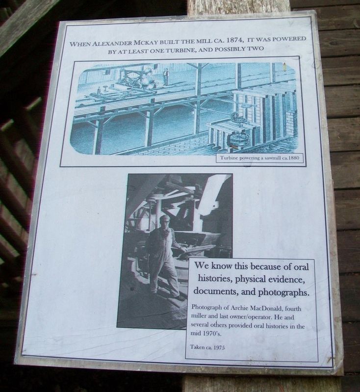
Turbines began to become commonplace in the mid-1800's and had virtually replaced vertical waterwheels by the mid 1860's.
Below are a number of illustrations showing typical mill setups and power transfer.
In 1881 the Schoellkopf Power Station . . . — — Map (db m108183) HM
On Sunrise Trail (Nova Scotia Route 6) just west of Nova Scotia Route 326, on the left when traveling east.
Within this iron fence lies
Duncan MacLanders
1788 - 1870
and
Johanne Faulkner
1788 - 1876
First of the line to leave the
shores of Scotland and seek a freer
and fuller life in the New World.
Erected by descendants in . . . — — Map (db m108165) HM
On Glooscap Trail (National Route 2) 0.5 kilometers west of Belmont Road/Fort Belcher Road, on the right when traveling west.
English: This was the chief route of the French and Indians from Cobequid to Isle St. Jean and Louisbourg and later of the British from Halifax to Charlottetown.
Français: C’était la route principale des Français . . . — — Map (db m139192) HM
On Tidal Bore Road, 0.6 kilometers north of Glooscap Trail (Nova Scotia Route 236), on the left when traveling north.
In 1760-62 near this Head of Cobequid Bay the first English speaking settlers of the Townships of Onslow and Truro landed. Of Ulster Irish, Scottish and English stock, these pioneers were among those brought to Nova Scotia from New England by the . . . — — Map (db m108717) HM
On Main Street (Nova Scotia Route 6) at Church Street, on the left when traveling west on Main Street.
In this harbour Capt. David Donahew of New England with three armed vessels surprised Lieut. Paul Marin's allied force en route from Annapolis Royal to Louisbourg. He drove them ashore, disheartened the Canadian Indians and prevented the French . . . — — Map (db m108133) HM
On Main Street at Church Street, on the right when traveling east on Main Street.
In memory of those
who gave their lives
in the Great War
1914 - 1918
Alexander Henderson • George McIntosh
Freeman McLellan • Harry McLellan
George Powers • Arthur Rose • William Tattrie
Roy Weatherby • George Weatherby
Orrin F. . . . — — Map (db m108154) WM
On Nova Scotia Route 311 at Balmoral Road (Nova Scotia Route 256), on the left when traveling north on Provincial Route 311.
The land for the church was
donated by
Mr. John R. Hayman
and was contracted to be
built for the sum of one
thousand, four hundred
thirty two dollars.
The closing service for
St. Andrew's Presbyterian
Church was held
December . . . — — Map (db m108184) HM
On Prince Street just east of Lorne Street, on the left when traveling east.
Legend
This plaque commemorates
The centennial of the formation of the Presbyterian Church in Canada in 1875;
The ministry of the Rev. Daniel Cock (1771-1805) of Greenock, Scotland, and the Rev. David Smith (1771-1795) of St. Andrew's, . . . — — Map (db m108220) HM
On Prince Street just east of Louise Street, on the right when traveling east.
The Lumber Jack represents the exciting role Truro has played in development of forestry in Nova Scotia. Truro has always been, and still is today, a centre of forestry activity. The forest industry continues to be the backbone of the local and . . . — — Map (db m108243) HM
On Prince Street at Lorne Street, on the left when traveling east on Prince Street.
This building, opened in 1884, was erected to house the Post Office, Customs and Internal Revenue. Designed under the supervision of federal Chief Architect Thomas Fuller, the Truro Post Office was part of a nation-wide programme to house federal . . . — — Map (db m108244) HM
On Prince Street at Forrester Street, on the right when traveling east on Prince Street.
Erected by the
Citizens of Truro
In Honor of the Men
who during
The Great War
1914 - 18
nobly upheld the
honor of the Empire
in France and Flanders
and gave their lives
that right shall prevail
[World War II] 1939 - 45 . . . — — Map (db m108214) WM