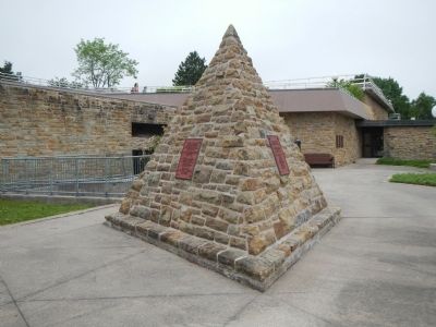
Alexander Graham Bell,
Teacher of the deaf
Humanitarian and inventor,
Became the first member of
The Telephone Pioneers of America,
On November, 2, 1911.
The Telephone Pioneers of America,
Are proud to dedicate this cairn
To . . . — — Map (db m79993) HM
Near Chebucto Street (Nova Scotia Route 205), on the right when traveling west.
English:
The Park commemorates the humanitarian and scientific achievements of Alexander Graham Bell (1847-1922) and his associates
Frederick W. Baldwin • John A.D. McCurdy • Glenn H. Curtiss • Thomas E. Selfridge
Most of the . . . — — Map (db m80007) HM
Near Chebucto Street (Nova Scotia Route 205) 0.2 kilometers east of Jones Street, on the left when traveling east.
English:
In the summer and fall of 1918, the valiant Canadian Corps, 100,000 strong, spearheaded a series of costly allied victories, now known as "Canada's Hundred Days" that led to the Armistice. During the First World War, more . . . — — Map (db m139694) HM
On Chebucto Street (Nova Scotia Route 205) close to Prince Street.
Commemorating The work of the Aerial Experiment Association which resulted in the first aeroplane flight within the British Empire made by J.A.D. McCurdy at Baddeck, Nova Scotia, on February 23, 1909. The Aerial Experiment Association was founded . . . — — Map (db m79992) HM
Near Chebucto Street (Nova Scotia Route 205) 0.2 kilometers east of Jones Street, on the left when traveling east.
English:In honor of the Aerial Experiment Association consisting of
Alexander Graham Bell
F. W. Baldwin
Glenn H. Curtiss
J. A. D. McCurdy
Thomas E. Selfridge
and of the Silver Dart which they
designed and built . . . — — Map (db m139879) HM
On Water Street close to Margaret Street, on the right when traveling north.
English: Derived from the Mi’kmaq name, ‘Abadak’, meaning “place with island near”, Baddeck’s first European settler was British officier James Duffus in 1819. He made his home on the “island near” and it was known . . . — — Map (db m80077) HM
On Shore Road (Nova Scotia Route 205) close to Twining Street, on the left when traveling west.
Commemorating
the founding of the
Home and School
Movement in Canada
December 18th, 1895
The
Parents Association
of Baddeck
held its first meeting on this, the site of the Baddeck academy.
The idea of such an . . . — — Map (db m79999) HM
Near Chebucto Street (Nova Scotia Route 205), on the right when traveling west.
English:
On February 23, 1909, more than 100 people witnessed the first successful powered flight in Canada, as the Silver Dart lifted off the ice of Baddeck Bay and flew 800 metres. The biplane, piloted by J. A. D. McCurdy, reached a . . . — — Map (db m79990) HM
On Chebucto Street (Nova Scotia Route 205) close to Queen Street, on the left when traveling west.
arrived in Baddeck in 1835. It is believed he was sent from Halifax by the executors of the estate of the late James Duffus in order to settle up his business affairs. Young Mr. Kidston, it is said, fell “madly in love” with the widow . . . — — Map (db m80006) HM
Near Chebucto Street (Nova Scotia Route 205) 0.2 kilometers east of Jones Street, on the left when traveling east.
English: Women in Canada and Newfoundland were profoundly affected by the First World War. Overseas, they served as paid nurses and volunteers. On the home front, they laboured in factories, worked the land, ran patriotic . . . — — Map (db m139699) HM
On Nova Scotia Route 312, on the right when traveling south.
English:
Bird Islands is actually made up of two individual islands - Hertford and Ciboux. Home to an ancient Mi’kimaq legend, the great deity, Ktchi’scam, molded prophet Glooscap out of the earth ad breathed life into him with a . . . — — Map (db m151126) HM
On Nova Scotia Route 312, on the right when traveling south.
English:
Settled, 1629, by Captain Charles Daniel, and site of an early Jesuit Mission. Selected, 1713, as a naval base and one of the principal places in Isle Royale, named Port Dauphin and strongly fortified. Its importance declined with . . . — — Map (db m80005) HM
On Cabot Trail, on the right when traveling south.
1st War - Veterans - 2nd War
Killed in Action 1914 - 1918
Thompson Brewer
George Donavan
Charles MacDonald
Killed in Action
1939 - 1945
Murdoch J. Ross
Joseph Doucette
Daniel Smith
Bert Nicks
An additional 83 veterans . . . — — Map (db m139871) WM
On Lighthouse Road just east of New Haven Road, on the right when traveling east.
English:
With its close proximity to abundant fishing grounds, sheltered cove and excellent fish-drying conditions, Neil's Harbour was a popular fishing base for both French and Scottish settlers in the 1700's.
Neil MacLennan, . . . — — Map (db m139870) HM
Near Cabot Trail close to Mackillop Road, on the left when traveling south.
English:
As clergyman, schoolmaster and magistrate, he moulded the character of this community for a generation. Born at Stoer Point, Assynt, Scotland, he emigrated to Pictou in 1817, led his band of Scots to St. Ann in 1820 and remained . . . — — Map (db m80004) HM
On Cabot Trail at South Ridge Road, on the right when traveling south on Cabot Trail.
In grateful memory of
the men who gave
their lives
in two World Wars
1939-1945
E.J. Cameron
D.C. MacDonald
T. J. MacDonald
R. N. MacInnes
H. J. MacLennan
C. MacLennan
E. MacLennan
N. MacLennan
J. A. MacNeil
1914-1918
M. . . . — — Map (db m139337) WM