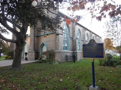
On King Street East (Provincial Highway 2) at Church Street, on the left when traveling east on King Street East.
This Anglican church was begun in 1851 to replace a frame building erected in 1820. Distinguished by the stepped battlements of its façade, the new building was designed in early Gothic Revival style by the noted architect Kivas Tully, who was . . . — — Map (db m90045) HM
On 3rd Street, 0.2 kilometers south of Albert Street, on the left when traveling south.
Largely financed by the citizens and town, Cobourg's railway to Peterborough was chartered 1852 and opened 1854. Like many others of this period, it suffered from excessive optimism, land speculation and faulty engineering. Ice made the . . . — — Map (db m90087) HM
On King Street west (Provincial Highway 2) at Matthew Street, on the right when traveling west on King Street west.
Leila Maria Koerber, a talented actress and singer known internationally as Marie Dressler, was born in Cobourg. About 1883 she joined a touring stock company, later gaining recognition on Broadway in a series of successful comedy productions, . . . — — Map (db m90090) HM
On King Street East (Provincial Highway 2) near College Street, on the right when traveling east.
This walk, sponsored by the Cobourg branch of the Architectural Conservancy of Ontario, honors Egerton Ryerson, one of the founders of Upper Canada Academy in 1832 and its second principal. The Academy, which later became Victoria College and . . . — — Map (db m90054) HM
On 3rd Street, 0.2 kilometers south of Albert Street, on the left when traveling south.
Saw and grist mills erected in this area during the first decade of the 19th century fostered the development here of a small settlement. The completion of the Kingston Road by 1817 facilitated its growth and within a decade it had a population of . . . — — Map (db m90089) HM
On University Avenue East at College Street, on the left when traveling east on University Avenue East.
The cornerstone of this building was laid June 7, 1832, and teaching began in 1836. First operated under a royal charter by the Weslayan Methodists as Upper Canada Academy, in 1841 it obtained a provincial charter under the name of Victoria . . . — — Map (db m90042) HM
On King Street West (Provincial Highway 2) west of 2nd Street, on the left when traveling west.
One of the finest public buildings in Canada, this imposing structure was built as an expression of civic pride and confidence in the future. It was begun in 1856 and opened by the Prince of Wales four years later. Designed by the renowned . . . — — Map (db m90084) HM
On King Street West (Provincial Highway 2) east of 3rd Street, on the right when traveling east.
This building, designed by the architect Kivas Tully in a Victorian version of the Palladian style, is representative of the finer public buildings of mid-nineteenth century Canada. One of the most impressive town halls in Ontario, it reflects the . . . — — Map (db m90086) HM
On King Street East (Provincial Highway 2) east of McGill Street, on the right when traveling east.
This resident of Cobourg was the province's leading stage-coach proprietor from about 1830 to 1856. His Royal Mail Line ran from Hamilton to Montréal, with links to other centres. In February, 1840, Weller drove the Governor-General, Charles . . . — — Map (db m90082) HM