Welcome to the Historical Marker Database
Public history cast in metal, carved on stone, or embedded in resin
Marker of the Week
Nuclear Accident at Three Mile Island Middletown, Pennsylvania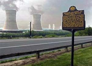 In commemoration of Earth Week, this marker reminds us of the events at Three Mile Island near Middletown, Pennsylvania. In 1979, it was the scene of the United States' "worst commercial nuclear accident" with released radiation, a damaged nuclear core and evacuations of thousands of people from the area. It's a cautionary tale that has forever affected the nuclear industry. Contributor Steve Fernie of Arlington, Virginia filed this entry in 2007.
Article fetched in less than 1 ms.
Take a Tour of the Database
Click on the star button in the menu above. Repeat. Every time you click, you will be shown a different entry at random.More Than 211 Thousand!
Hundreds added monthly. ...▼
The latest entry was published earlier today at 1:48 AM ET.
Historical Marker Facts
These counts are as of last night and also include war memorials.
How many historical markers are there in the United States? We’ve found 195,124 so far. Adding more daily.
What state has the most historical markers? We’ve found the most in Texas. New York, Pennsylvania, Virginia, and California round out the top five.
How many historical markers are there in Canada? We’ve found 4,501 so far. We’re always looking for more.
Entries Recently Added
Recently Modified Entries
Most Viewed Entries This Year
Tag Pages to Create Lists
When you are signed in, you will see these small buttons ➀ ➁ ➂ ➃ ➄ on marker pages and search results. Click on them to tag that marker. Return to the page to see what you've tagged and to create lists, maps, and spreadsheets.
To get started, click on to sign in. First time users can register from there. Tag and map your next weekend outing!
History Happened Here
National and global events all happened somewhere, and historical markers mark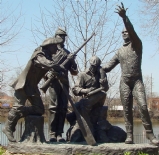
Frontiersman, Soldier,
Writer, Astronaut
Markers tell stories and point out facts. There is one at the site the northernmost battle of the U.S. Civil War and another at the southernmost point in the United States (can you guess where?). There is one next to a 17th century Japanese stone lantern symbolizing 20th century peace, and another one less than 20 miles away reminding us of the Nike missile sites that were built the same year the lantern was dedicated. They tell of battles,
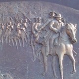
Generals Captured in their
Union Suits, Literally!
There are countless thousands of great stories marked by markers—and some boring ones too. Some markers simply recite facts while others are insightful, obscure, cryptic, patriotic, fascinating, sad, funny, or just downright bizarre. Many of those markers are on these pages, others are waiting for you to discover and add them to this database.
So hit the road and experience history first-hand yourself. History happened nearby.
Suggestions? Problems?
We want to hear from you. Send a note to the editors.Are You A Collector?
Do you collect historical markers? Would you like to start? If you’re a collector, or want to get started,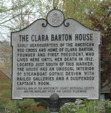
Clara Barton,
Steamboat Gothic Aficionado
You can add markers yourself. It's easy! Check marker submission guidelines, then click to get started. Adding photos, links and commentary is just as easy: go the marker's page and click on the links at the top or bottom of the page.
HMdb.org Cards
3½" x 2" wallet cards are available. |
Keep An Eye on Those Markers
Get a list of markers near where you live and work and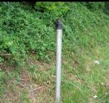 keep an eye out for them when you're out on the road. You would be surprised how many disappear in the course of a year.
To report a missing marker, use the “Correct This Page” link on the marker’s page and scroll down to the “Is Marker Missing?” section. A photo of the stump, hole in the ground, or place where the marker was is necessary for proof. Also, please take a few minutes and inform your local historical society.
Recommend This Website
Middle School History Project
Teachers! Are you looking for a history project idea that will actively involve your students and their parents? Take a look at this historical marker passport project used by teachers in the Wilson NY School District for 7th and 8th grade students. Download the customizable two-page Microsoft Word document by clicking here.Attention Historical Societies
Do we have entries for all of the historical markers in your area? Here is a suggestion for an article for your next newsletter that may get your membership to help fill in the gaps.Do you have some history that you want to publish on the Internet? HMdb.org can provide static hosting space at HistoryArchives.org at no charge. What you want to publish does not have to be related to a historical marker. For more information, contact an editor.