Myrtle Beach in Horry County, South Carolina — The American South (South Atlantic)
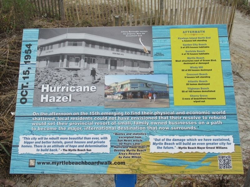
Hurricane Hazel
Oct. 15, 1954
Garden City Beach · 3 of 275 houses habitable
Surfside Beach · 4 of 70 houses habitable
Myrtle Beach · Most structures east of Ocean Blvd. destroyed or damaged
Windy Hill · 50 of 89 houses destroyed
Crescent Beach · 2 houses left standing
Atlantic Beach · 25 homes destroyed
Tilghman Beach · 50 of 100 houses demolished
Cherry Grove · 2 rows of beachfront houses wiped out
“This city will be rebuilt more beautiful than ever, with bigger and better hotels, guest houses and private homes. There is an attitude of hope and determination to build back.” – The Myrtle Beach Sun
“Out of the damage which we have sustained, Myrtle Beach will build an even greater city for the future.” - Myrtle Beach Mayor Ernest Williams
*Quotes and statistics excerpted from Sun News article “50 Years Later Hurricane Hazel Didn’t Destroy Myrtle Beach Area’s Resolve” by Zane Wilson
Topics. This historical marker is listed in this topic list: Disasters.
Location. 33° 41.513′ N, 78° 52.732′ W. Marker is in Myrtle Beach, South Carolina, in Horry County. Marker can be reached from the intersection of North Ocean Boulevard and 9th Ave N., on the right when traveling north. Located on the Myrtle Beach Boardwalk and Promenade. Touch for map. Marker is at or near this postal address: 100 9th Ave N, Myrtle Beach SC 29577, United States of America. Touch for directions.
Other nearby markers. At least 8 other markers are within walking distance of this marker. The King’s Highway (here, next to this marker); Marine Amphibious Assault (within shouting distance of this marker); Myrtle Beach Pavilions (within shouting distance of this marker); Salt Works (within shouting distance of this marker); The Bowery (within shouting distance of this marker); a different marker also named Hurricane Hazel (about 300 feet away, measured in a direct line); Hurricane Hugo (about 500 feet away); Grand Strand (about 600 feet away). Touch for a list and map of all markers in Myrtle Beach.
Also see . . .
1. Hurricane Hazel on Wikipedia. (Submitted on January 2, 2017, by Michael Herrick of Southbury, Connecticut.)
2. Myrtle Beach Boardwalk. (Submitted on January 2, 2017, by Michael Herrick of Southbury, Connecticut.)
Credits. This page was last revised on January 2, 2017. It was originally submitted on January 2, 2017, by Michael Herrick of Southbury, Connecticut. This page has been viewed 938 times since then and 22 times this year. Photos: 1, 2. submitted on January 2, 2017, by Michael Herrick of Southbury, Connecticut.

