Deadwood in Lawrence County, South Dakota — The American Midwest (Upper Plains)
Chinatown
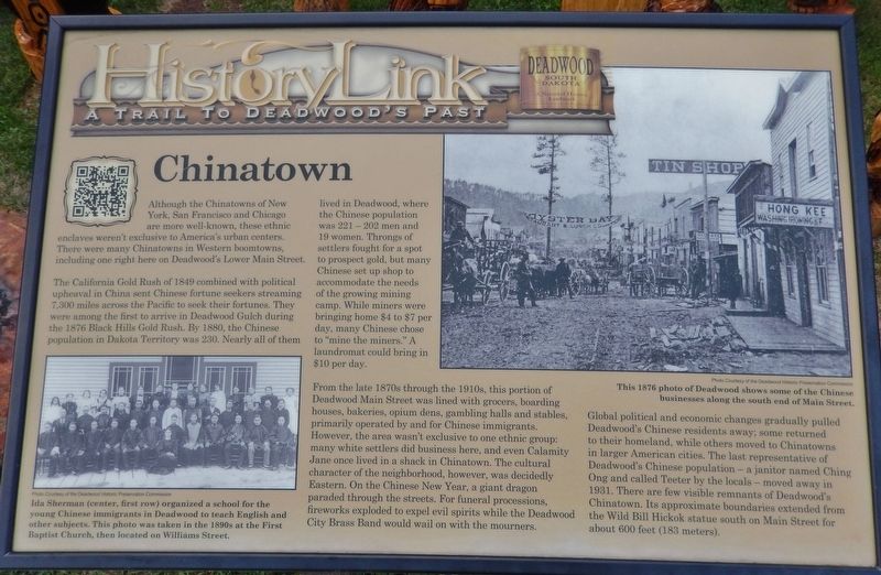
Although the Chinatowns of New York, San Francisco and Chicago are more well-known, these ethnic enclaves weren't exclusive to America's urban centers. There were many Chinatowns in Western boomtowns, including one right here on Deadwood's Lower Main Street.
The California Gold Rush of 1849 combined with political upheaval in China sent Chinese fortune seekers streaming 7,300 miles across the Pacific to seek their fortunes. They were among the first to arrive in Deadwood Gulch during the 1876 Black Hills Gold Rush. By 1880, the Chinese population in Dakota Territory was 230. Nearly all of them lived in Deadwood, where the Chinese population was 221 — 202 men and 19 women. Throngs of settlers fought for a spot to prospect gold, but many Chinese set up shop to accommodate the needs of the growing mining camp. While miners were bringing home $4 to $7 per day, many Chinese chose to "mine the miners." A laundromat could bring in $10 per day.
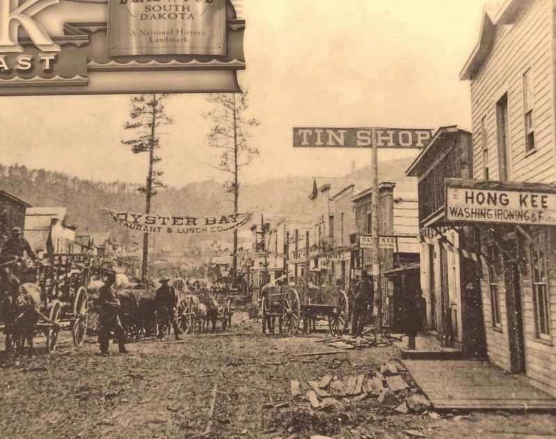
From the late 1870s through the 1910s, this portion of Deadwood Main Street was lined with grocers, boarding houses, bakeries, opium dens, gambling halls and stables, primarily operated by and for Chinese immigrants. However, the area wasn't exclusive to one ethnic group: many white settlers did business here, and even Calamity Jane once lived in a shack in Chinatown. The cultural character of the neighborhood, however, was decidedly Eastern. On the Chinese New Year, a giant dragon paraded through the streets. For funeral processions, fireworks exploded to expel evil spirits while the Deadwood City Brass Band would wail on with the mourners.
Global political and economic changes gradually pulled Deadwood's Chinese residents away; some returned to their homeland, while others moved to Chinatowns in larger American cities. The last representative of Deadwood's Chinese population — a janitor named Ching Ong and called Teeter by the locals — moved away in 1931. There are few visible remnants of Deadwood's Chinatown. Its approximate boundaries extended from the Wild Bill Hickok statue south on Main Street for about 600 feet (183 meters).
Erected by The Deadwood Historic Preservation Commission.
Topics. This historical marker is listed in these topic lists: Asian Americans • Industry & Commerce • Settlements & Settlers. A significant historical year for this entry is 1876.
Location. 44° 22.769′ N, 103° 43.616′ W. Marker is in Deadwood, South Dakota, in Lawrence County. Marker is on Main Street, 0.1 miles south of CanAm Highway (U.S. 85), on the left when traveling north. Marker is located beside the sidewalk, on the west side of the street. Touch for map
. Marker is at or near this postal address: 566 Main Street, Deadwood SD 57732, United States of America. Touch for directions.
Other nearby markers. At least 8 other markers are within walking distance of this marker. Historic Facade Replication (about 600 feet away, measured in a direct line); Wild Bill Hickok (about 600 feet away); Historic Site Saloon Number 10 (about 700 feet away); The Badlands (approx. 0.2 miles away); Wall & Main Street: Commercial Center (approx. 0.2 miles away); Jewish American Pioneers and Deadwood (approx. 0.2 miles away); Early Placer Mining Operations in Deadwood (approx. 0.2 miles away); Elizabethtown (approx. 0.2 miles away). Touch for a list and map of all markers in Deadwood.
Also see . . .
1. Deadwood Chinatown. Encyclopedia of the Great Plains website entry:
Joining another western gold rush, Chinese began to arrive in the Black Hills, Dakota Territory, from Montana, Colorado, and Wyoming in the mid-1870s. Their population soon increased to nearly 300. Most of them resided in the Deadwood-Lead area. Although some of the Chinese engaged in placer mining, an overwhelming majority of these Asian immigrants found their calling in service businesses. Encountering relatively mild racial prejudice, the Chinese immigrants were able to open their businesses anywhere in the region. Chinese-owned washhouses and restaurants dotted the city of Deadwood. Nevertheless, the voluntary congregation of
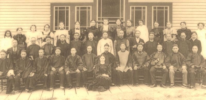
Courtesy of the Deadwood Historic Preservation Commission
3. Marker detail: School for Chinese Immigrants, c. 1890s
Ida Sherman (center, first row) organized a school for the young Chinese immigrants in Deadwood to teach English and other subjects. This photo was taken in the 1890s at the First Baptist Church, then located on Williams Street.
2. Deadwood’s Chinese underground. Underneath the Gold Nugget Trading Post lies a labyrinth of sorts, representing an important historic part of Deadwood — remnants of underground Chinatown. The flood of 1883 destroyed upper Main Street. Residents rebuilt on top of existing rock walls, creating the legendary Chinese tunnel system. They used them to deliver goods, for their laundry services, and there was an ordinance that said the Chinese were not allowed on Main Street after dark, so they would use the tunnels to go back and forth from Main Street to the Chinese district. (Submitted on July 15, 2018, by Cosmos Mariner of Cape Canaveral, Florida.)
Credits. This page was last revised on October 21, 2022. It was originally submitted on July 13, 2018, by Cosmos Mariner of Cape Canaveral, Florida. This page has been viewed 939 times since then and 124 times this year. Photos: 1. submitted on July 13, 2018, by Cosmos Mariner of Cape Canaveral, Florida. 2, 3, 4, 5. submitted on July 15, 2018, by Cosmos Mariner of Cape Canaveral, Florida. • Andrew Ruppenstein was the editor who published this page.
