Whitesville in Boone County, West Virginia — The American South (Appalachia)
Upper Big Branch Mine Explosion
— 5 April 2010 —
Inscription.
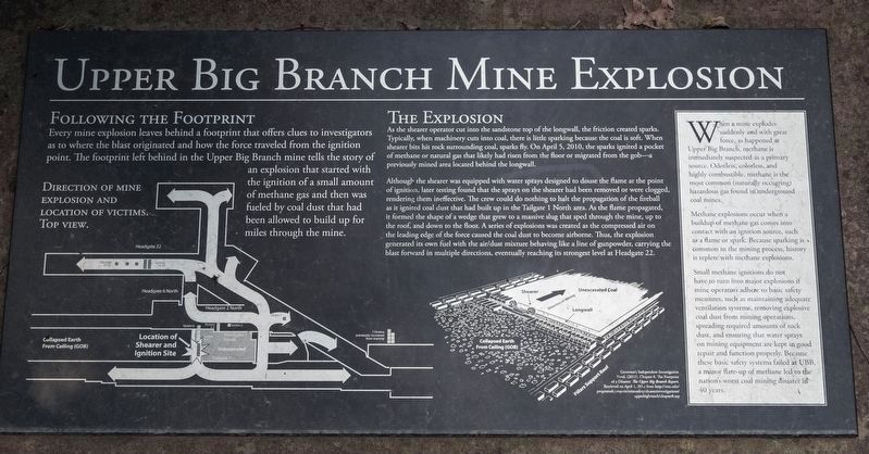
Following the footprint. Every mine explosion leaves behind a footprint that offers clues to investigators as to where the blast originated and how the force traveled from the ignition point. The footprint left behind in the Upper Big Branch mine tells the story of an explosion that started with the ignition of a small amount of methane gas and then was fueled by coal dust that had been allowed to build up for miles through the mine.
The Explosion. As the shearer operator cut into the sandstone top of the longwall, the friction created sparks. Typically, when machinery cuts into coal, there is little sparking because the coal is soft. When shearer bits hit rock surrounding coal, sparks fly. On April 5, 2010, the sparks ignited a pocket of methane or natural gas that likely had risen from the floor or migrated from the gob — a previously mined area located behind the longwall.
Although the shearer was equipped with water sprays designed to douse the flame at the point of ignition, later testing found that the sprays on the shearer had been removed or were clogged, rendering them ineffective. The crew could do nothing to halt the propagation of the fireball as it ignited coal dust that had built up in the Tailgate 1 North area. As the flame propagated, it formed the shape of a wedge that grew to a massive slug that sped through the mine, up to the roof, and down to the floor. A series of explosions was created as the compressed air on the leading edge of the force caused the coal dust to become airborne. Thus, the explosion generated its own fuel with the air/dust mixture behaving like a line of gunpowder, carrying the blast forward in multiple directions, eventually reaching its strongest level at Headgate 22.
(sidebar)
When a mine explodes suddenly and with great force, as happened at Upper Big Branch, methane is immediately suspected as a primary source. Odorless, colorless, and highly combustible, methane is the most common (naturally occurring) hazardous gas found in underground coal mines.
Methane explosions occur when a buildup of methane gas comes into contact with an ignition source, such as a flame or spark. Because sparking is common in the mining process, history is replete with Methane explosions.
Small methane ignitions do not have to turn into major explosions if mine operators adhere to basic safety measures, such as maintaining adequate ventilation systems, removing explosive coal dust from mining operations, spreading required amounts of rock dust, and ensuring that water sprays on mining equipment are kept in good repair and function properly. Because these basic safety
systems failed at Upper Big Branch Mine,
a minor flare-up of methane led to the
nation’s worst coal mining disaster in
40 years.
Topics. This historical marker is listed in these topic lists: Disasters • Industry & Commerce • Natural Resources. A significant historical date for this entry is April 5, 2010.
Location. 37° 58.765′ N, 81° 32.048′ W. Marker is in Whitesville, West Virginia, in Boone County. Marker is on Coal River Road (West Virginia Route 3) just west of Bridge Avenue, on the right when traveling east. Touch for map. Marker is in this post office area: Whitesville WV 25209, United States of America. Touch for directions.
Other nearby markers. At least 8 other markers are within 13 miles of this marker, measured as the crow flies. A different marker also named Upper Big Branch Mine Explosion (here, next to this marker); West Virginia Coal Mine Disasters (here, next to this marker); Big Coal River (a few steps from this marker); Upper Big Branch Miners Memorial (within shouting distance of this marker); Battle of Coal River (approx. 0.2 miles away); The Whitesville School (approx. 0.2 miles away); William S. Dunbar (approx. 11.4 miles away); Mary Ingles (approx. 13.1 miles away). Touch for a list and map of all markers in Whitesville.
Also see . . . Upper Big Branch Miners Memorial Website. (Submitted on August 5, 2019.)
Credits. This page was last revised on August 11, 2019. It was originally submitted on August 5, 2019, by J. J. Prats of Powell, Ohio. This page has been viewed 462 times since then and 112 times this year. Photos: 1, 2, 3. submitted on August 5, 2019, by J. J. Prats of Powell, Ohio.


