Nankin in Brooks County, Georgia — The American South (South Atlantic)
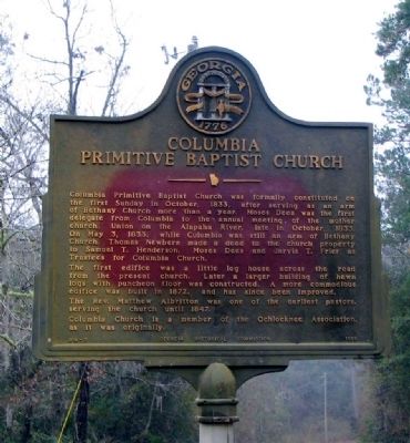
Columbia Primitive Baptist Church
The first edifice was a little log house across the road from the present church. Later a larger building of hewn logs with puncheon floor was constructed. A more commodious edifice was built in 1872, and has since been improved.
The Rev. Matthew Albritton was one of the earliest pastors, serving the church until 1847.
Columbia Church is a member of the Ochlocknee Association, as it was originally.
Erected 1953 by Georgia Historical Commission. (Marker Number 014-7.)
Topics and series. This historical marker is listed in this topic list: Churches & Religion. In addition, it is included in the Georgia Historical Society series list. A significant historical month for this entry is May 1980.
Location. 30° 39.754′ N, 83° 28.651′ W. Marker is in Nankin, Georgia, in Brooks County. Marker is on Radford Road (County Route 114) ¾ mile west of Madison Highway (Georgia Route 333), on the left when traveling west. The marker is at the church, on a unnamed dirt road leading south from Radford Road. Touch for map. Marker is in this post office area: Quitman GA 31643, United States of America. Touch for directions.
Other nearby markers. At least 8 other markers are within 10 miles of this marker, measured as the crow flies. Shiloh Methodist Church (approx. 4.4 miles away in Florida); Concord Missionary Baptist Church (approx. 5 miles away in Florida); Quitman United Methodist Church (approx. 9.6 miles away); Civil War Slave Conspiracy (approx. 9.8 miles away); Brooks County Veterans Monument (approx. 9.8 miles away); Brooks County (approx. 9.8 miles away); Our Confederate Dead (approx. 9.8 miles away); Quitman Veterans Memorial (approx. 9.8 miles away).
Credits. This page was last revised on January 26, 2020. It was originally submitted on December 27, 2008, by David Seibert of Sandy Springs, Georgia. This page has been viewed 1,857 times since then and 11 times this year. Photo 1. submitted on December 27, 2008, by David Seibert of Sandy Springs, Georgia. • Kevin W. was the editor who published this page.
Editor’s want-list for this marker. A wide view photo of the marker and the surrounding area together in context. • Can you help?
