Faber in Nelson County, Virginia — The American South (Mid-Atlantic)
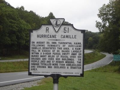
Hurricane Camille
Erected 1972 by Virginia Historic Landmarks Commission. (Marker Number R-51.)
Topics and series. This historical marker is listed in this topic list: Disasters. In addition, it is included in the Virginia Department of Historic Resources (DHR) series list. A significant historical year for this entry is 1969.
Location. 37° 50.698′ N, 78° 48.944′ W. Marker is in Faber, Virginia, in Nelson County. Marker is on Thomas Nelson Highway (U.S. 29) 0.1 miles east of Tidbit Trail, on the right when traveling east. Touch for map. Marker is in this post office area: Faber VA 22938, United States of America. Touch for directions.
Other nearby markers. At least 8 other markers are within 7 miles of this marker, measured as the crow flies. Boyhood Home of Colonel John Mosby (approx. 2.6 miles away); William H. Crawford (approx. 4.4 miles away); Nelson County / Albemarle County (approx. 4.7 miles away); Rockfish Church (approx. 4.9 miles away); a different marker also named Hurricane Camille (approx. 5.6 miles away); Nelson County World War Memorial (approx. 6.6 miles away); Nelson County World War II Memorial (approx. 6.6 miles away); Nelson County Courthouse (approx. 6.6 miles away).
Also see . . . Hurricane Camille. Article from the Encyclopedia Virginia. (Submitted on October 19, 2009, by Craig Swain of Leesburg, Virginia.)
Credits. This page was last revised on June 16, 2016. It was originally submitted on October 19, 2009, by Craig Swain of Leesburg, Virginia. This page has been viewed 1,938 times since then and 60 times this year. Photos: 1. submitted on October 19, 2009, by Craig Swain of Leesburg, Virginia. 2, 3. submitted on March 6, 2011, by Kevin W. of Stafford, Virginia.


