St. Florian in Lauderdale County, Alabama — The American South (East South Central)
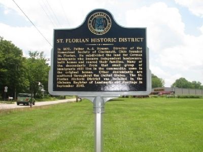
St. Florian Historic District
Erected by Alabama Historical Commission.
Topics and series. This historical marker is listed in this topic list: Settlements & Settlers. In addition, it is included in the Alabama Historical Commission series list. A significant historical month for this entry is September 2007.
Location. 34° 52.393′ N, 87° 37.438′ W. Marker is in St. Florian, Alabama, in Lauderdale County. Marker is at the intersection of Old Jackson Hwy and Co Rd 47/Old Jackson Hwy and Co Rd 30 St. Florian on Old Jackson Hwy. Touch for map. Marker is in this post office area: Florence AL 35630, United States of America. Touch for directions.
Other nearby markers. At least 8 other markers are within 3 miles of this marker, measured as the crow flies. St. Michael's Catholic Church (approx. 0.2 miles away); Wilson Family Cemetery 19th Century / Slave Cemetery 19th Century (approx. 1.6 miles away); Tate Springs Estate Early 1800’s (approx. 2.2 miles away); Shoals Creek Preserve Tract (approx. 2.3 miles away); Andrew Jackson's Military Road (approx. 2.4 miles away); Deibert Park (approx. 2.6 miles away); Larimore Home (approx. 2.7 miles away); Governor Hugh McVay Home Site and Cemetery (approx. 2.9 miles away). Touch for a list and map of all markers in St. Florian.
Credits. This page was last revised on June 16, 2016. It was originally submitted on September 3, 2010, by Sandra Hughes Tidwell of Killen, Alabama, USA. This page has been viewed 1,146 times since then and 81 times this year. Photos: 1, 2, 3, 4. submitted on September 3, 2010, by Sandra Hughes Tidwell of Killen, Alabama, USA. • Bill Pfingsten was the editor who published this page.


