Near Leming in Atascosa County, Texas — The American South (West South Central)
Battle of Medina
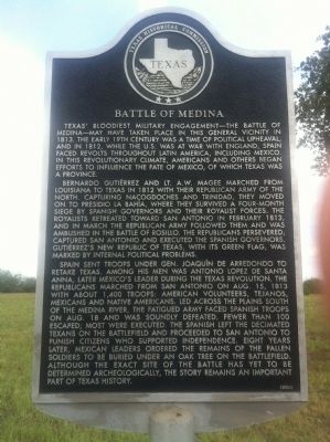
Texas' bloodiest military engagement -- the Battle of Medina -- may have taken place in this general vicinity in 1813. The early 19th century was a time of political upheaval, and in 1812, while the U.S. was at war with England, Spain faced revolts throughout Latin America, including Mexico. In this revolutionary climate, Americans and others began efforts to influence the fate of Mexico, of which Texas was a province.
Bernardo Gutiérrez and Lt. A.W. Magee marched from Louisiana to Texas in 1812 with their Republican Army of the North. Capturing Nacogdoches and Trinidad, they moved on to Presidio La Bahía, where they survived a four-month siege by Spanish governors and their Royalist forces. The Royalists retreated toward San Antonio in February 1813, and in March the Republican Army followed them and was ambushed in the Battle of Rosillo. The Republicans persevered, captured San Antonio and executed the Spanish governors. Gutiérrez's new Republic of Texas, with its green flag, was marked by internal political problems.
Spain sent troops under Gen. Joaquín de Arredondo to retake Texas. Among his men was Antonio Lopez de Santa Anna, later Mexico's leader during the Texas Revolution. The Republicans marched from San Antonio on Aug. 15, 1813 with about 1,400 troops: American volunteers, Tejanos, Mexicans and Native Americans. Led across the plains south of the Medina River, the fatigued army faced Spanish troops on Aug. 18 and was soundly defeated. Fewer than 100 escaped; most were executed. The Spanish left the decimated Texans on the battlefield and proceeded to San Antonio to punish citizens who supported independence. Eight years later, Mexican leaders ordered the remains of the fallen soldiers to be buried under an oak tree on the battlefield. Although the exact site of the battle has yet to be determined archeologically, the story remains an important part of Texas history.
Erected 2005 by State Historical Survey Committee. (Marker Number 13310.)
Topics. This historical marker is listed in these topic lists: Exploration • War of 1812. A significant historical month for this entry is February 1813.
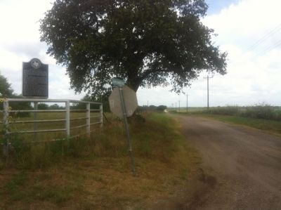
Location. Marker has been reported missing. It was located near 29° 6.525′ N, 98° 32.327′ W. Marker was near Leming, Texas, in Atascosa County. Marker was at the intersection of Old Applewhite Road and Bruce Road, on the right when traveling south on Old Applewhite Road. Touch for map. Marker was in this post office area: Leming TX 78050, United States of America. Touch for directions.
Other nearby markers. At least 8 other markers are within 9 miles of this location, measured as the crow flies. Kings Highway Camino Real — Old San Antonio Road (approx. 2.9 miles away); Shiloh Cemetery (approx. 3.2 miles away); a different marker also named Kings Highway Camino Real — Old San Antonio Road (approx. 3½ miles away); a different marker also named Kings Highway Camino Real — Old San Antonio Road (approx. 4.6 miles away); Poteet (approx. 5½ miles away); Brite Cemetery (approx. 6.7 miles away); Site of Jose Antonio Navarro Ranch Headquarters (approx. 8.3 miles away); Oak Island Methodist Church (approx. 8½ miles away). Touch for a list and map of all markers in Leming.
More about this marker. A contributor notes that the marker may be missing as of April 13, 2021 due to school construction at the location.
Credits. This page was last revised on April 16, 2021. It was originally submitted on June 20, 2012, by John A Hensarling of Campbellton, Texas. This page has been viewed 1,810 times since then and 86 times this year. Photos: 1, 2. submitted on June 21, 2012, by John A Hensarling of Campbellton, Texas. • Craig Swain was the editor who published this page.

