Downtown in Lincoln in Lancaster County, Nebraska — The American Midwest (Upper Plains)
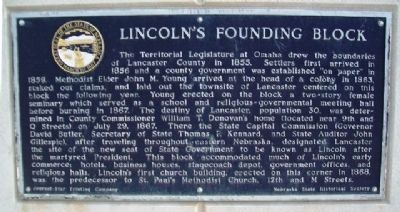
Lincoln's Founding Block
The Territorial Legislature at Omaha drew the boundaries of Lancaster County in 1855. Settlers first arrived in 1856 and a county government was established "on paper" in 1859. Methodist Elder John M. Young arrived at the head of a colony in 1863, staked out claims, and laid out the townsite of Lancaster centered on this block the following year. Young erected on the block a two-story female seminary which served as a school and religious-governmental meeting hall before burning in 1867. The destiny of Lancaster, population 30, was determined in County Commissioner William T. Donovan's home (located near 9th and Q Streets) on July 29, 1867. There the State Capital Commission (Governor David Butler, Secretary of State Thomas P. Kennard, and State Auditor John Gillespie), after traveling throughout eastern Nebraska, designated Lancaster the site of the new seat of State Government to be known as Lincoln after the martyred President. This block accommodated much of Lincoln's early commerce: hotels, business houses, stagecoach depot, government offices, and religious halls. Lincoln's first church building, erected on this corner in 1868, was the predecessor to St. Paul's Methodist Church, 12th and M Streets.
Erected by Journal-Star Printing Company and Nebraska State Historical Society . (Marker Number 254.)
Topics and series. This historical marker is listed in this topic list: Settlements & Settlers. In addition, it is included in the Nebraska State Historical Society series list. A significant historical date for this entry is July 29, 1867.
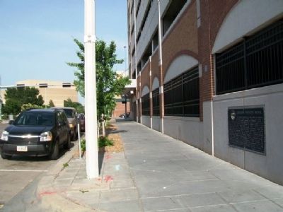
Location. 40° 48.943′ N, 96° 42.462′ W. Marker is in Lincoln, Nebraska, in Lancaster County. It is in Downtown. Marker is on Q Street west of 10th Street (U.S. 34), on the left when traveling west. Marker is on the wall near the northwest corner of the multi-level parking garage. Touch for map. Marker is in this post office area: Lincoln NE 68508, United States of America. Touch for directions.
Other nearby markers. At least 8 other markers are within walking distance of this marker. Original Site of St. Paul Methodist Church (within shouting distance of this marker); Lincoln Fixture Building (about 500 feet away, measured in a direct line); Ridnour Building (about 600 feet away); Huber Building (about 600 feet away); Veith Building (about 600 feet away); Harpham Building (about 600 feet away); H. P. Lau Building (about 700 feet away); U.S. Post Office and Courthouse (Old City Hall) (about 700 feet away). Touch for a list and map of all markers in Lincoln.
Also see . . . History of the City of Lincoln, Nebraska by Hayes & Cox (1889). Internet Archive website entry (Submitted on July 20, 2013, by William Fischer, Jr. of Scranton, Pennsylvania.)
Credits. This page was last revised on February 16, 2023. It was originally submitted on July 20, 2013, by William Fischer, Jr. of Scranton, Pennsylvania. This page has been viewed 606 times since then and 19 times this year. Photos: 1, 2. submitted on July 20, 2013, by William Fischer, Jr. of Scranton, Pennsylvania.

