Sackets Harbor in Jefferson County, New York — The American Northeast (Mid-Atlantic)
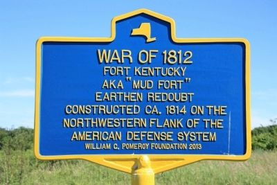
Fort Kentucky
Fort Kentucky
aka "Mud Fort"
earthen redoubt
constructed ca. 1814 on the
northwestern flank of the
American defense system
Erected 2013 by William G. Pomeroy Foundation.
Topics and series. This historical marker is listed in these topic lists: Forts and Castles • War of 1812. In addition, it is included in the William G. Pomeroy Foundation series list. A significant historical year for this entry is 1812.
Location. 43° 56.855′ N, 76° 7.811′ W. Marker is in Sackets Harbor, New York, in Jefferson County. Marker is on Ontario Street south of Washington Street, on the left when traveling south. This historical marker is located on park lands that are southwest of the Sackets Harbor Battlefield State Park, along a roadway that runs along the Lake Ontario shoreline. Touch for map. Marker is in this post office area: Sackets Harbor NY 13685, United States of America. Touch for directions.
Other nearby markers. At least 8 other markers are within walking distance of this marker. Smoothbore Muzzle Loader Cannon (about 300 feet away, measured in a direct line); The British Advance is Halted (about 300 feet away); The British Observation Point (about 400 feet away); British Attack on Sackets Harbor (about 400 feet away); The Landing Area (about 500 feet away); American Dragoon Commander Wounded (approx. 0.2 miles away); a different marker also named Smoothbore Muzzle Loader Cannon (approx. 0.2 miles away); Welcome to Sackets Harbor Battlefield (approx. ¼ mile away). Touch for a list and map of all markers in Sackets Harbor.
Also see . . . Sackets Harbor Battlefield - National Archives. National Register of Historic Places documentation (Submitted on February 25, 2024, by Anton Schwarzmueller of Wilson, New York.)
Credits. This page was last revised on February 25, 2024. It was originally submitted on July 26, 2014, by Dale K. Benington of Toledo, Ohio. This page has been viewed 440 times since then and 22 times this year. Photos: 1, 2, 3, 4. submitted on July 26, 2014, by Dale K. Benington of Toledo, Ohio.


