Ogdensburg in St. Lawrence County, New York — The American Northeast (Mid-Atlantic)
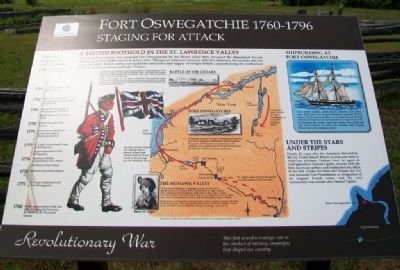
Fort Oswegatchie 1760-1796
Staging for Attack
— Revolutionary War —
This fort served a strategic role in the conduct of military campaigns that shaped our country.
A British Foothold in the St. Lawrence Valley
Fort de la Présentation was renamed Fort Oswegatchie by the British when they occupied the abandoned French mission at the end of the French & Indian War. Though on American territory after the American Revolution, the fort remained under British control and aided the settlement and supply of refugee British Loyalists along the north shore of the St. Lawrence River and Lake Ontario.
In September 1775, Captain George Forster led soldiers of the 8th Regiment of Foot (The King's Regiment) from Fort Oswegatchie along, with militia and Iroquois allies to Les Cedres, 28 miles west of Montreal, where they defeated Continental troops defending a small stockade.
Forster's forces pushed onto the Island of Montreal where American troops counterattacked. With the help of two four-pounder guns captured at Les Cedres, Forster prevented Brigadier General Benedict Arnold's soldiers from pursuing his forces across the Ottawa River.
[Map captions read]
Burgoyne's army moved up Lake Champlain to reach the Hudson River.
Fort Oswegatchie
Originally named Fort de la Présentation, the fort was built by French missionary Abbé François Picquet in 1749 to serve as a mission to the Iroquois and supply base for French forays into the interior of the American continent.
The Mohawk Valley
During General Burgoyne's campaign to divide the colonies by taking control of the Hudson River, Colonel Barry St. Leger's forces likely stopped at Fort Oswegatchie. They were on their way to capture Fort Stanwix at the head of the Mohawk River. The siege failed, and St. Leger's force could not proceed down river to link with Burgoyne's army at Albany.
British forces at Oswegatchie and their Indian allies continued to support raids into the Mohawk Valley. They attacked Fort Stanwix and raided Fort Dayton, Canada Creek, and Ellice's Mill at Little Falls, taking food, forage, and livestock.
St. Leger's plan to join Burgoyne was thrwarted at Fort Stanwix. Raiding parties entered the Oswego River, boated across Lake Oneida and up Wood Creek to the portage into the Mohawk River.
Map based on an 18th century drawing, distortions resulted from the incomplete data available at the time.
Shipbuilding at Fort Oswegatchie
Two armed vessels, called snows (rhymes with cows), were built here; the 16-gun Haldimand and the 18-gun Seneca. The St. Lawrence River at the time flowed through stretches of rapids that were passable by small boats only. By building the vessels above the rapids, they could sail into Lake Ontario to reach the Oswego and Niagara Rivers and other strategic points.
Under the Stars and Stripes
Nearly 20 years after the American Revolution, the Jay Treaty forced Britain to evacuate forts in American territory. Nathan Ford, an agent of land speculator Samuel Ogden, arrived with the first American settlers and established his office in the fort. Under the Stars and Stripes, the fort was renamed Fort Presentation in recognition of its original French name, and the new community was named after Samuel Ogden.
Timeline of British Occupation
1796 Americans take control of the fort.
1783 Hostilities ended by the Treaty of Paris.
1782 British forces from Fort Oswegatchie raid Ellice's Mill at Little Falls.
1781 Cornwallis surrenders to Washington at Yorktown.
British forces raid Canada Creek.
1780 British forces raid Fort Dayton.
1779 British forces attack Fort Stanwix and take 40 Americans prisoner.
1777 St. Leger's unsuccessful siege of Fort Stanwix.
1776 Americans declare independence from Britain.
1775 American Revolution begins.
1771 The 16-gun Haldimand built at Fort Oswegatchie.
1760 Britain takes control of the fort after

Photographed By Larry Gertner, May 15, 2021
3. Fort de La Presentation
Fort website homepage
Click for more information.
Click for more information.
Erected by Fort de la Présentation Association.
Topics and series. This historical marker is listed in these topic lists: Forts and Castles • Patriots & Patriotism • Settlements & Settlers • War, US Revolutionary. In addition, it is included in the Great Lakes Seaway Trail National Scenic Byway series list. A significant historical month for this entry is September 1775.
Location. 44° 41.667′ N, 75° 30.073′ W. Marker is in Ogdensburg, New York, in St. Lawrence County. Marker is on the Downtown Arterial (New York State Route 68) west of Commerce Street, on the right when traveling west. Touch for map. Marker is in this post office area: Ogdensburg NY 13669, United States of America. Touch for directions.
Other nearby markers. At least 8 other markers are within walking distance of this marker. Fort la Présentation (here, next to this marker); Fort de la Présentation - 1749-1759 (here, next to this marker); Fort Lévis - 1760 (here, next to this marker); The Battle of Ogdensburg (here, next to this marker); Aka Se We':Ka Tsi (Oswegatchie) (here, next to this marker); Fort de la Présentation (here, next to this marker); Abbe Picquet 1708 -1781 (about 400 feet away, measured in a direct line); Mission Fort (about 500 feet away). Touch for a list and map of all markers in Ogdensburg.
Also see . . .
1. History of Fort Oswegatchie. 1000 Islands: An International Tourism Destination entry (Submitted on August 1, 2014, by William Fischer, Jr. of Scranton, Pennsylvania.)
2. Fort Oswegatchie During The American Revolution. NYY 360 entry (Submitted on February 12, 2021, by Larry Gertner of New York, New York.)
Credits. This page was last revised on December 25, 2023. It was originally submitted on August 1, 2014, by William Fischer, Jr. of Scranton, Pennsylvania. This page has been viewed 830 times since then and 79 times this year. Photos: 1. submitted on August 1, 2014, by William Fischer, Jr. of Scranton, Pennsylvania. 2. submitted on July 28, 2014, by William Fischer, Jr. of Scranton, Pennsylvania. 3. submitted on May 23, 2021, by Larry Gertner of New York, New York.

