Saint John in Saint John County, New Brunswick — The Atlantic Provinces (North America)
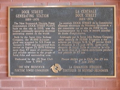
Dock Street Generating Station
Le Centrale Dock Street
— 1889-1976 —
The New Brunswick Electric Power Commission’s DOCK STREET PLANT, built on this site in 1889, was the longest continually operating electrical generation station in the world.
Built by the Saint John Railway Company, the 18,000 kilowatt plant was acquired by N B Power on January 1, 1948 and was retired from service on August 23, 1976 following more than 87 years of continuous and reliable service to the people of Saint John and surrounding area.
June 23, 1983
French
La centrale DOCK STREET de la Commission d’énergie électrique de Nouveau-Brunswick a été construite sur ce site en 1889 et son fonctionnement lui a valu le record mondial de durée d’exploitation.
Aménagée par la Saint John Railway Company, cette centrale de 18,000 kilowatts a été achetée par Energie N.-B. le 1er janvier 1948 et déclassée le 23 août 1976, après avoir desservi de façon fiable et continue la ville de Saint-Jean et la région avoisinante pendant une période de 87 ans.
le 23 juin 1983
Erected 1983 by New Brunswick Electric Power Commission.
Topics. This historical marker is listed in this topic list: Industry & Commerce. A significant historical month for this entry is January 1832.
Location. 45° 16.365′ N, 66° 3.975′ W. Marker is in Saint John, New Brunswick, in Saint John County. Marker can be reached from Smythe Street. Touch for map. Marker is in this post office area: Saint John NB E2L, Canada. Touch for directions.
Other nearby markers. At least 8 other markers are within walking distance of this marker. Partridge Island (within shouting distance of this marker); Canada’s Original City (within shouting distance of this marker); Saint John Harbour Defensive Network (about 120 meters away, measured in a direct line); Defending the Harbour (about 120 meters away); Electrifying the Uptown (about 150 meters away); Oland Family Breweries (about 180 meters away); The Landing of the Loyalists (about 210 meters away); Saint John – The Working Port (approx. 0.3 kilometers away). Touch for a list and map of all markers in Saint John.
More about this marker. This marker is located at Market Square next to the Saint John River. Access is by walking along the Harbour Passage Tail
Also see . . . In the Beginning - Electricity Comes to New Brunswick. NBPower.com's history of electric power in New Brunswick: ...The 1890s also ushered in the era of electric-powered public transit systems.The Consolidated Electric Company, incorporated in 1892, announced plans to electrify and extend the existing horsepowered street railway system in Saint John. Six electrified horse cars were purchased in Boston and poles and wires were erected.The system required more electricity than the existing plants could supply so a new powerhouse with a 133 horsepower generator was constructed on the corner of Union and Dock Streets.The first electric trolley cars appeared on the streets of Saint John on March 31, 1893…. (Submitted on October 2, 2014.)
Credits. This page was last revised on June 16, 2016. It was originally submitted on September 29, 2014, by Barry Swackhamer of Brentwood, California. This page has been viewed 530 times since then and 27 times this year. Photo 1. submitted on September 29, 2014, by Barry Swackhamer of Brentwood, California. • Andrew Ruppenstein was the editor who published this page.
Editor’s want-list for this marker. Photo of the marker and its surroundings. • Can you help?
