Pierrepont in St. Lawrence County, New York — The American Northeast (Mid-Atlantic)
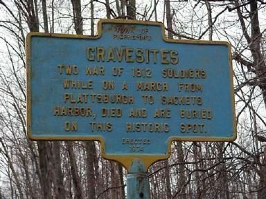
War of 1812 Gravesites
Inscription.
Two War of 1812 soldiers while on a march from Plattsburgh to Sackets Harbor, died and are buried on this historic spot.
Erected 1974 by Town of Pierrepont.
Topics. This historical marker is listed in this topic list: War of 1812. A significant historical year for this entry is 1812.
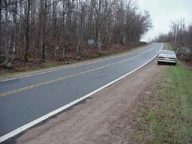
Location. 44° 33.967′ N, 74° 59.139′ W. Marker is in Pierrepont, New York, in St. Lawrence County. Marker is on Russell-Pierrepont Road (County Route 24) 1.3 miles south of New York State Route 56, on the left when traveling north. Google maps refers to it as Brown Bridge Road. Touch for map. Marker is in this post office area: Colton NY 13625, United States of America. Touch for directions.
Other nearby markers. At least 8 other markers are within 7 miles of this marker, measured as the crow flies. Cox's Mill (approx. 3.2 miles away); This was the First Road in the Town of Parishville (approx. 4.7 miles away); Patriot Burials (approx. 5.9 miles away); The History of Sunday Rock (approx. 6 miles away); Site of Log Cabin of Luke Brown (approx. 6 miles away); Bayside Cemetery (approx. 6.3 miles away); Home and Country (approx. 6.3 miles away); Jerry Welsh Gymnasium (approx. 6.6 miles away).
More about this marker. It is not a good area for parking a vehicle.
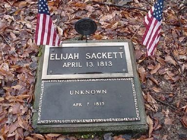
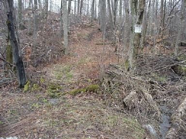
Regarding War of 1812 Gravesites. Two soldiers in War of 1812 died and were buried here. Two graves are about 20-30 feet from side of road down small but maintained path.
Also see . . . Anne Cady's Inventory of 1812 Soldiers Gravesite- Pierrepont, NY. RootsWeb website entry (Submitted on November 29, 2008, by Kevin W. of Stafford, Virginia.)
Additional commentary.
1. 1812 Soldiers’ Graves Will Be In Pierrepont Hands
The below is the text from the article by Deidre Kelly, originally published in the Daily Courier-Observer, Friday, on August 2, 2002. The source is linked above.
PIERREPONT--A small historical site featuring two War of 1812 soldiers’ graves along County Route 24 will now be officially deeded to the town of Pierrepont.
Town attorney Charles B. Nash told the town board a parcel of land near the site was recently surveyed and the people interested in the adjacent lot wanted to make sure it is deeded to the town.
Nash noted the land probably belonged to the town at one time, but by signing the deed, the town’s ownership would be official.
Town Supervisor William Ford signed the necessary documents to ensure the town legally owns the historic property, which is now badly overgrown with waist-high weeds and brush. The cost of filing the documents is $65. Nash said it was basically a matter of cleaning up the ownership issue.
The town will now be responsible for taking care of the 0.95 acre plot near the telephone tower base, which will initially entail clearing out brush and making paths. Once the preliminary work is done, the upkeep will consist of keeping the site mowed.
The graves are located near the back of the property, about 280 feet off the road. Town Clerk Norma V. Casolara said people would probably enjoy walking back to view the graves if there were clear trails and definite grave markers. Now the only way a person can tell the graves are even located at the site is by the blue historical sign by the road.
Nash suggested a Boy Scout looking to earn his Eagle Scout badge might want to consider taking over the project. He said it would be a great way to research some local history and serve the community.
"There’s probably an interesting story behind the soldiers," Nash said.
Ford noted he had stopped at the site many times to view the graves, but had no luck finding them because he didn’t realize they were so far back.
Nash included a record map of of the grave sites with the deed so future generations would always be aware with their exact location.
— Submitted November 29, 2008, by Kevin W. of Stafford, Virginia.
2. RE: Elijah Sackett
This Elijah Sackett may very well be the Elijah Sackett that is referred to in the Military Minutes of the Council of Appointment, State of New York 1783-1821, Volume 4, on pages 498, 935 and 1090.
This Elijah Sackett was born 31 Jan. 1768 at Sheffield, Berkshire Massachusetts USA and Died on 7 April 1813. He was Married to Dorothy Buell. In 1800 he was with the Washington County NY Militia serving under Lt. Col. Commandant Solomen, Kings Regt., as an Ensign (Page 498). In 1807 he was promoted to Lt.
Elijah Sacket was with Col. Solomon Bakers Regt (pp. 934-935) of the Brigade of Militia of Washington Co. New York. Warren Ferriss was the Brigadier General there. It states on pg. 1090 that in 1809 that Lt. vice Sacket moved.
— Submitted December 27, 2010, by Patricia Regan of Cape Vincent, New York USA.
Credits. This page was last revised on February 12, 2022. It was originally submitted on November 26, 2008, by Phil Garringer of Colton, New York. This page has been viewed 2,859 times since then and 63 times this year. Last updated on October 10, 2014, by Russell Nelson of Potsdam, New York. Photos: 1. submitted on November 26, 2008, by Phil Garringer of Colton, New York. 2, 3, 4. submitted on November 29, 2008. • Bill Pfingsten was the editor who published this page.


