Near Fort Washington in Prince George's County, Maryland — The American Northeast (Mid-Atlantic)
Battery Decatur and Disappearing Guns
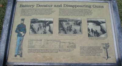
American coastal defenses were modernized from the 1890s to 1910 with the development of the Endicott System. Emphasis in military tactics shifted the masonry fortifications to more effective weapons based on rifled steel guns, improved breech-loading systems, better propellants (gunpowder), and reinforced concrete gun emplacements.
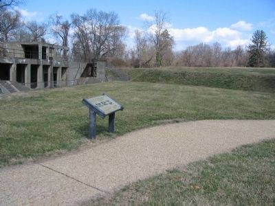
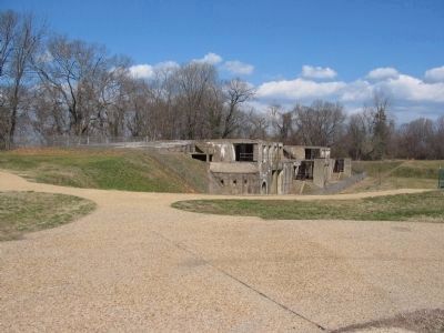
Here you will see the remains of Battery Decatur, a reinforced concrete emplacement completed in 1891. It mounted two 10-inch disappearing guns similar to the Fort Monroe rifled gun shown in the photographs below. The lower rooms of the battery were for shot, shell, and powder storage with cranes and hoists that moved the heavy ammunition up to the gun platforms.
Topics. This historical marker is listed in these topic lists: Forts and Castles • Military. A significant historical year for this entry is 1910.
Location. 38° 42.77′ N, 77° 1.951′ W. Marker is near Fort Washington, Maryland, in Prince George's County. Marker can be reached from Fort Washington Road , on the right when traveling south. Located in Fort Washington Park, between the parking lot and the visitors center. Touch for map. Marker is at or near this postal address: 13551 Fort Washington Road, Fort Washington MD 20744, United States of America. Touch for directions.
Other nearby markers. At least 8 other markers are within walking distance of this marker. Fort Washington Park (within shouting distance of this marker); Capital Guardian (within shouting distance of this marker); a different marker also named Capital Guardian (within shouting distance of this marker); a different marker also named Capital Guardian (within shouting distance of this marker); Main Gateway (about 600 feet away, measured in a direct line); The Northwest Demi-Bastion (about 700 feet away); The Water Battery (approx. 0.2 miles away); New Guns for an Old Fort (approx. 0.2 miles away). Touch for a list and map of all markers in Fort Washington.
More about this marker. The marker displays a series of photographs showing cannon of the type described in action. In the first the crew is Breech-loading a projectile into the rifled gun. Next the crew is Bringing up the propellant charge. Finally The gun has fired and recoiled below the parapet, ready to be reloaded.
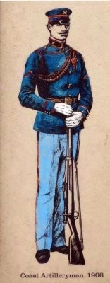
On the left a drawing shows a dress uniform of a Coast Artilleryman circa 1906.
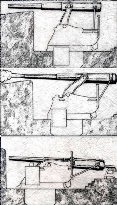
In the lower center a line drawing demonstrates the Ingenious disappearing gun carriages used recoil energy to lower the gun out of sight of the enemy for reloading and servicing. These 10-inch guns had a firing range of approximately seven miles.
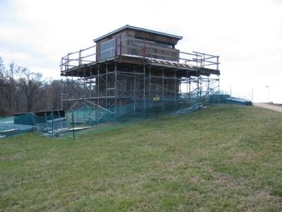
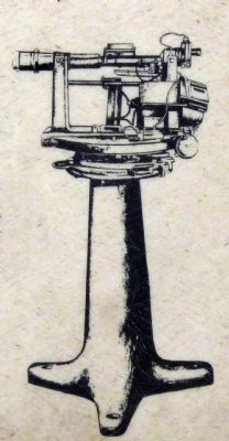
On the lower right a drawing of a gun sight is captioned: The guns were aimed and fired by means of complex range finding and fire control equipment centered in the Battery Commander's Station, visible to your left. This Depression Position Finder, mounted in the tower, located the target exactly.
Also see . . .
1. Coast Defenses of the Potomac. National Park Service page detailing the post-Civil War defenses of the nation's capital. (Submitted on May 26, 2008, by Craig Swain of Leesburg, Virginia.)
2. Battery Decatur. National Park Service Fort Washington Park

Photographed By Craig Swain
3. Battery Decatur
The open areas on the lower level were for storage of ammunition and supplies. The guns were mounted on two disappearing carriages in the center of the structure, with their mounts divided by a traverse, seen here in the center of the battery structure. On the far right, between the path and the battery, is the sunken road that would have connected to a similar, but larger, 12-in gun battery. That battery was never completed.
Additional commentary.
1. Battery Decatur
Additional details are offered on a brochure from the National Park Service:
- Originally named "Emplacement B," it was changed to honor Commodore Stephen N. Decatur in 1900.
- Work began on the battery in 1893, but was delayed waiting for the proper gun and carriages. Not until 1897 were the guns mounted.
- The guns were Model 1888 10-inch Rifled Cannon. These measured over 30 feet in length and weighted 67,200 pounds. The disappearing carriage weighed an additional 196,000 pounds.
- The guns could fire approximately one round every four minutes originally. Later with improved fire control and hoist equipment this increased to one round every 15 seconds.
- The recoil of the gun raised a 73,000 pound counter balance. When released, the counter balance brought the gun back to firing position. Much like a giant see-saw.
- The battery construction
contained 45 feet of concrete with an additional 53 feet of earth to protect the guns, crew, and ammunition.
- The battery was renovated in 1903-1905 with new equipment to service the guns (speeding the loading process).
-The battery was manned by about 95 personnel, including 3 officers. Battery A, 4th U.S. Artillery manned the fort until 1904. Later in 1905, the battery was re-designated 37th Company, Coast Artillery. By 1909 the 119th Coast Artillery Company took over the assignment.
- From 1898 onward, measures were taken to camouflage the battery. The concrete was painted darker colors. In addition trees and shrubs were placed in front of the works.
- The Battery included a unique set of rifle ports to protect the emplacements from the rear. This was not replicated on any other battery constructed during the time period. Additionally a sunken path was constructed to allow passage to another planned battery of 12-inch guns.
- The guns were dismounted in 1917 and sent to France for use as railroad guns during World War I.
— Submitted May 26, 2008, by Craig Swain of Leesburg, Virginia.
Photographed By Craig Swain, March 1, 2008
6. Side Profile of the Battery
Note the sunken area behind the emplacement and the "built up" earth in front of the battery. Since several different concrete mixing techniques were used, and local river sand was a primary ingredient, the battery has not weathered well.
Photographed By Allen C. Browne, December 7, 2013
8. Disappearing Guns
Ingenious disappearing carriages used recoil to lower the gun out of sight of the enemy for reloading and servicing. These 10-inch guns had a firing range of approximately seven miles.
close-up of three images on marker (re-arranged)
Photographed By Allen C. Browne, December 7, 2013
9. Depression Position Finder
The guns were aimed and fired by means of complex range finding and fire control equipment centered in the Battery Commander's Station, visible to your left. This Depression Position Finder, mounted in the tower, located the target exactly.Close-up of image on marker
Credits. This page was last revised on June 22, 2022. It was originally submitted on May 26, 2008, by Craig Swain of Leesburg, Virginia. This page has been viewed 2,266 times since then and 31 times this year. Photos: 1, 2, 3, 4, 5, 6. submitted on May 26, 2008, by Craig Swain of Leesburg, Virginia. 7, 8, 9. submitted on December 10, 2013, by Allen C. Browne of Silver Spring, Maryland.
