Near Caraquet in Gloucester County, New Brunswick — The Atlantic Provinces (North America)
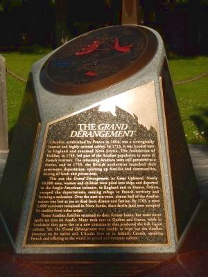
Le Grand Dérangement
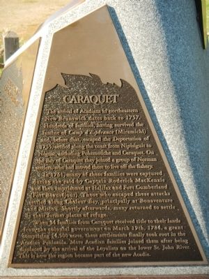
Caraquet
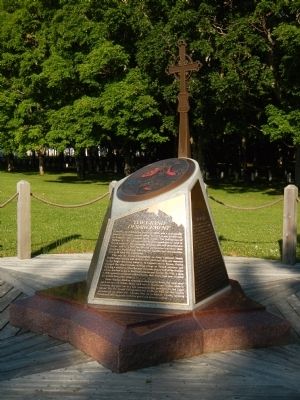
L’Acadie, established by France in 1604, was a strategically located and highly coveted colony. In 1713, it was handed over to England and renamed Nova Scotia. The foundation of Halifax, in 1749, led part of the Acadian population to move to French territory. The remaining Acadians were still perceived as a threat, and in 1755, the British authorities launched their systematic deportation, splitting up families and communities, seizing all lands and possessions.
This was the Grand Dérangement or Great Upheaval. Nearly 10,000 men, women, and children were piled into ships and deported to Anglo-American colonies, to England and to France. Others escaped the deportation, seeking refuge in French territory and forming a resistance. Over the next ten years, almost half of the Acadian nation was lost at sea or died from disease and famine. By 1765, a mere 1,600 survivors remained in Nova Scotia, their fertile land now occupied by settles from other areas.
Some Acadian families returned to their former home, but most never again set eyes on Acadie. Many took root in Quebec and France, while in Louisiana they gave rise to a new community that produced the rich Cajun culture. Yet, the Grand Dérangement was unable to wipe out the Acadian presence on its native soil. L’Acadie lives on in Atlantic Canada, speaking French and offering to the world its proud and dynamic culture.
The arrival of Acadians in northeastern New Brunswick dates back to 1757. Hundreds of families, having survived the famine of Camp d’Espérance (Miramichi) and, before that, escaped the Deportations of 1755, settled along the coast from Nipisiguit to Néguac, including Pokemouche and Caraquet. On the Bay of Caraquet they joined a group of Norman settlers, who had moved there to live off the fishery.
In 1751, many of these families were captured during the raid by Captain Roderick MacKenzie and then imprisoned at Halifax and Fort Cumberland (Fort Beauséjour). Those who escaped these attacks settled along Chaleur Bay, principally at Bonaventure and Mistou. Shortly afterwards, many returned to settle in their former places of refuge.
When 34 families from Caraquet received title to their lands from the colonial government on March 19th, 1784, a grant comprising 14,500 acres, these settlements finally took root in the Acadian Peninsula. More Acadian families joined them after being displaced by the arrival of the Loyalists on the lower St. John River. This is how the region became part of the new Acadie.
French:
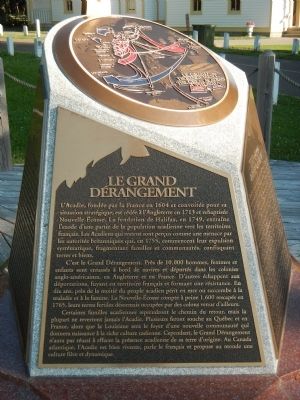
L’Acadie, fondée par la France en 1604 et convoitée pour sa situation stratégique, est cédée à l’Angleterre en 1713 et rebaptisée Nouvelle-Écosse. La fondation de Halifax, en 1749, entraîne l’exode d’une partie de la population acadienne vers les territories français. Les Acadiens qui restent son perçus comme un menace par les autorités britannique qui, en 1755, commençant leur expulsion systématique, fragmentant familles et communautés, confisquant terres et bien.
C’est la Grand Dérangement. Près de 10 000 hommes, femmes et enfants son entassés à bord de navires et déportes dans les colonies anglo-américaines, en Angleterre et en France. D’autres échappent aux déportations, fuyant en territoire français et formant une résistance. En dix ans, près de la moitié du peuple acadien périt en mer ou succombe à la maladie et à la famine. La Nouvelle-Écosse compte à peine 1 600 rescapés en 1765, leur terres fertiles désormais occupées par des colons venus d’ailleurs.
Certaines familles acadiennes reprendront le chemin du retour, mais le plupart ne reverront jamais l’Acadie. Plusieurs feront souche au Québec et en France, alors que la Louisiane sera le foyer d’une nouvelle communauté qui donnera naissance à la riche culture canadienne. Cependant, le Grand Dérangement n’aura pas réussi à effacer la présence acadienne de sa terre d’origine. Au Canada atlantique, l’Acadie est bien vivante, parle le français et propose au monde une culture fière et dynamique.
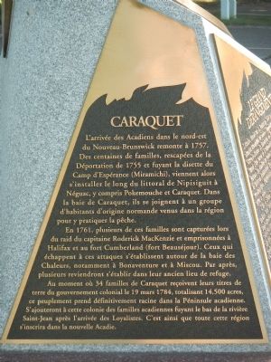
L’arrivée des Acadiens dans le nord-est de Nouveau-Brunswick remonte à 1757. Des centaines de families, rescapées de la Déportation de 1755 en fuyant la disette du Camp d’Espérance (Miramichi), viennent alors s’installer le long du littoral de Nipisiguit à Néguac, y compris Pokemouche et Caraquet. Dans la baie de Caraquet, ils se joignent à un groupe d’habitants d’origine normande venus dans la région pour y pratiquer le pêche.
En 1761, plusieurs de ces familles sont capturées lors du raid du capitaine Roderick MacKenzie et emprisonnées à Halifax et au fort Cumberland (fort Beauséjour). Ceux qui échappent à ces attaques s’établissent autour de la baie des Chaleurs, notamment à Bonaventure et à Moscou. Par après, plusieurs reviendront s’établir dans leur ancien lieu de refuge.
Au moment ou 34 familles de Caraquet reçoivent leur titres de terre du gouvernement colonial le 19 mars 1984, totalisant 14 500 acres, ce peuplement prend définitivement racine dans la Péninsule acadienne. S’ajouteront à cette colonie des familles acadiennes fuyant le bas de la rivière Saint-Jean après l’arrivée des Loyalists. C’est ainsi qui toute cette région d’inscrira dans la nouvelle Acadie.
Erected 2007 by The Acadian Odyssey.
Topics and series. This historical marker is listed in this topic list: Disasters. In addition, it is included in the Acadian History series list. A significant historical month for this entry is March 1755.
Location. 47° 46.442′ N, 65° 0.679′ W. Marker is near Caraquet, New Brunswick, in Gloucester County. Marker can be reached from West St. Peter Boulevard (New Brunswick Route 11) close to Sainte Ann Street North, on the left when traveling east. Touch for map. Marker is at or near this postal address: 579 West St Peter Boulevard, Caraquet NB E1W 1A2, Canada. Touch for directions.
Other nearby markers. At least 1 other marker is within walking distance of this marker. The Return of the Acadians (about 120 meters away, measured in a direct line).
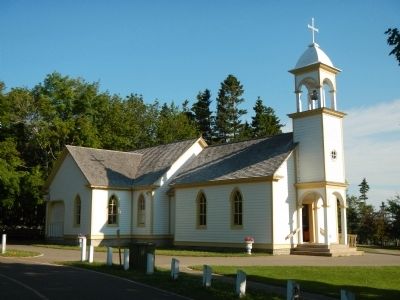
More about this marker. This monument is located near the Sainte-Anne-du-Bocage Shrine.
This is one of a planned 38 similar monuments on The Grand Dérangement (The Great Upheaval) to be erected by The Acadian Odyssey. Only eight have been placed so far.
Also see . . . Expulsion of the Acadians - Wikipedia. The Expulsion of the Acadians, also known as the Great Upheaval, the Great Expulsion and Le Grand Dérangement, was the forced removal by the British of the Acadian people from the present day Canadian Maritime provinces of Nova Scotia, New Brunswick, Prince Edward Island —an area also known as Acadie.[5] The Expulsion (1755–1764) occurred during the French and Indian War (the North American theatre of the Seven Years' War) and was part of the British military campaign against New France. (Submitted on February 1, 2015, by Barry Swackhamer of Brentwood, California.)
Additional keywords. Le Grand Dérangement
Credits. This page was last revised on June 16, 2016. It was originally submitted on February 1, 2015, by Barry Swackhamer of Brentwood, California. This page has been viewed 582 times since then and 48 times this year. Photos: 1, 2, 3, 4, 5, 6. submitted on February 1, 2015, by Barry Swackhamer of Brentwood, California. • Andrew Ruppenstein was the editor who published this page.
