Ranchester in Sheridan County, Wyoming — The American West (Mountains)
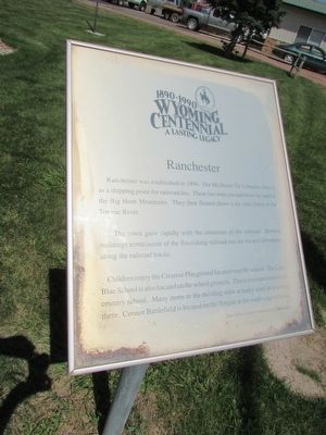
Ranchester
Ranchester was established in 1894. The McShane Tie Company used it as a shipping point for railroad ties. These ties were cut and hewn by hand in the Big Horn Mountains. They then floated down a six mile flume to the Tongue River.
The town grew rapidly with the extension of the railroad. Historic buildings reminiscent of the flourishing railroad era are located downtown along the railroad tracks.
Children enjoy the Creative Playground located near the school. The Little Blue School is also located on the school grounds. This is a restored one-room country school. Many items in the building were actually used in teaching there. Connor Battlefield is located on the Tongue at the south edge of town.
Erected 1990 by Sheridan County Centennial Committee.
Topics. This historical marker is listed in this topic list: Notable Places.
Location. 44° 54.533′ N, 107° 10.059′ W. Marker is in Ranchester, Wyoming, in Sheridan County. Marker is on Dayton Street (U.S. 14), on the right when traveling west. Marker is on Dayton Street, between 1st and 2nd Avenues. Touch for map. Marker is in this post office area: Ranchester WY 82839, United States of America. Touch for directions.
Other nearby markers. At least 8 other markers are within 6 miles of this marker, measured as the crow flies. Connor Battlefield (approx. 0.2 miles away); Connor Battlefield State Historic Site (approx. 0.3 miles away); Connor Battlefield State Park (approx. 0.4 miles away); The Battle of Tongue River (approx. 0.4 miles away); Bozeman Trail (approx. 3.2 miles away); Stagecoach Roads in Sheridan County (approx. 3.2 miles away); Tongue River Crossing (approx. 3.2 miles away); First Woman Mayor in Wyoming (approx. 5.2 miles away). Touch for a list and map of all markers in Ranchester.
Credits. This page was last revised on June 16, 2016. It was originally submitted on September 4, 2015, by Bill Coughlin of Woodland Park, New Jersey. This page has been viewed 321 times since then and 11 times this year. Photos: 1, 2, 3. submitted on September 4, 2015, by Bill Coughlin of Woodland Park, New Jersey.


