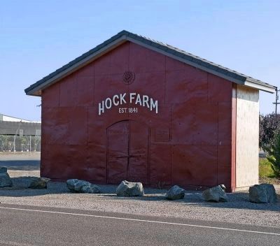
Yuba City in Sutter County, California — The American West (Pacific Coastal)
Hock Farm
— Established in 1841 —
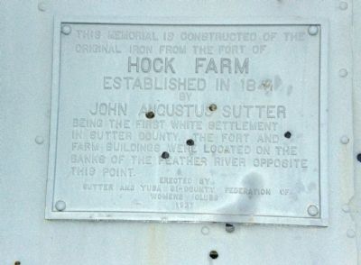
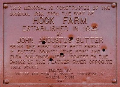
This memorial is constructed from the original iron from the fort of
Established in 1841
by
John Augustus Sutter
Erected 1927 by Sutter and Yuba Bi-County Federation of Womens Clubs.
Topics. This historical marker is listed in this topic list: Settlements & Settlers. A significant historical year for this entry is 1841.
Location. 39° 3.09′ N, 121° 36.95′ W. Marker is in Yuba City, California, in Sutter County. Marker is at the intersection of Garden Highway and Messick Road, on the right when traveling north on Garden Highway. Touch for map. Marker is at or near this postal address: 5230 Garden Highway, Yuba City CA 95991, United States of America. Touch for directions.
Other nearby markers. At least 8 other markers are within 6 miles of this marker, measured as the crow flies. Sutter's Hock Farm (approx. one mile away); Marysville Migrant Labor Campsite (approx. 2 miles away); Arboga Assembly Center (approx. 2.2 miles away); Masonic Temple Corner Stone (approx. 5.9 miles away); Sam Brannan Park (approx. 5.9 miles away); Chinese Rock Wall (approx. 6 miles away); Bok Kai Temple (approx. 6 miles away); Teegarden House (approx. 6 miles away). Touch for a list and map of all markers in Yuba City.
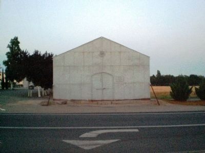
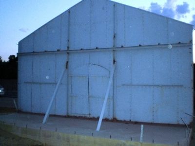
More about this marker. This is a peculiar memorial, standing ghost-like as a reminder of something long vanished. The text on the marker indicating that it had been built from the remains of a fort on the Hock Farm is somewhat at odds with various historical accounts, which would have that the metal building was a storehouse. But the distinction between a fort and a storehouse may be much greater now than it would have been back then.
The marker is on the memorial facade, to the right of the door.
Regarding Hock Farm. John Augustus Sutter is famous for being, in essence, the father of Sacramento, having established a trading post, and then fort and settlement, within what are now that city's limits. In 1841 he established the Hock Farm, roughly a day's horseback ride north of Sacramento. It was the first large-scale agricultural development in Northern California, with vineyards, orchards, and livestock. After gold was discovered at Sutter's Mill in Coloma in January 1848, a gold rush of epic proportions was unleashed. The ensuing chaos and deteriorating conditions at his fort in Sacramento led Sutter to retire, with his family, to the Hock Farm in 1850. Floods destroyed much of the farm in 1862, but he continued to live there until a fire in 1865 burned down his house, after which
he and his family moved to Pennsylvania. Sutter died in 1880.
Accounts vary as to the meaning of "Hock" in the farm's name, as it is either thought to be derived from the German word "hoch", meaning "high" (or in this sense, northwards) or be a corruption of the name of a former Native American settlement which was in the vicinity.
Other than the metal panels that make up the memorial, nothing more remains to be seen of the Hock Farm. The former farm site is on private land and currently planted in orchards.
Related marker. Click here for another marker that is related to this marker. A marker at the site of Sutter's Mill.
Also see . . . City of San Francisco's Virtual Museum Website John Sutter Webpage. This site provides a reasonably detailed and balanced biography of John Sutter, using both historical and autobiographical sources. (Submitted on July 9, 2008, by Andrew Ruppenstein of Lamorinda, California.)
Additional commentary.
1. Update
I was at the marker site July 17, 2011 and found your picture to be quite old. The metal building now has all four sides erected and painted. There is another marker on stone erected 100 feet on Hwy 99 just before the turnoff.
— Submitted July 18, 2011, by Danielle E. Cossu-Ferrara of Chico, California.
2. Sutter's Hock Farm, house
Sutter's house remains, with the second floor removed. It is located next to the levee.
— Submitted October 17, 2014, by Francis E. Coats of Yuba City, California.
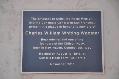
Photographed By Michael Kindig, April 5, 2014
5. Charles William Whiting Wooster Marker
and the Consulate General in San Francisco
present this plaque in honor and memory of
Charles William Whiting Wooster
Rear Admiral and one of the
founders of the Chilean Navy,
born in New Haven, Connecticut, 1780
He died on August 17, 1848, at
Sutter's Hock Farm, California
November, 2013
Credits. This page was last revised on June 16, 2016. It was originally submitted on July 9, 2008, by Andrew Ruppenstein of Lamorinda, California. This page has been viewed 2,743 times since then and 61 times this year. Photos: 1. submitted on July 9, 2008, by Andrew Ruppenstein of Lamorinda, California. 2. submitted on November 12, 2011, by Alvis Hendley of San Francisco, California. 3, 4. submitted on July 9, 2008, by Andrew Ruppenstein of Lamorinda, California. 5. submitted on April 8, 2014, by Michael Kindig of Elk Grove, California. 6. submitted on November 13, 2011, by Alvis Hendley of San Francisco, California. • Kevin W. was the editor who published this page.
