Dresden in Weakley County, Tennessee — The American South (East South Central)
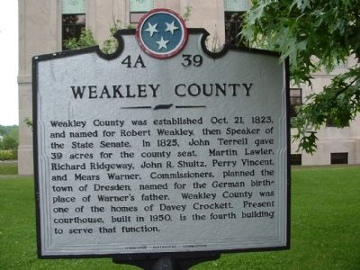
Weakley County
Erected by Tennessee Historical Commission. (Marker Number 4A 39.)
Topics and series. This historical marker is listed in this topic list: Settlements & Settlers. In addition, it is included in the Tennessee Historical Commission series list. A significant historical year for this entry is 1823.
Location. 36° 17.512′ N, 88° 42.513′ W. Marker is in Dresden, Tennessee, in Weakley County. Marker is at the intersection of West Main Street (Tennessee Route 89/54) and North Poplar Street, on the right when traveling west on West Main Street. Touch for map. Marker is at or near this postal address: 116 W Main St, Dresden TN 38225, United States of America. Touch for directions.
Other nearby markers. At least 8 other markers are within 16 miles of this marker, measured as the crow flies. Weakley County Tennessee Confederate Memorial (a few steps from this marker); New Salem Cumberland Presbyterian Church (approx. 4.1 miles away); Janes Mill (approx. 6.8 miles away); The University of Tennessee at Martin (approx. 9.2 miles away); Civil War Skirmish (approx. 9.8 miles away); Bethel College (approx. 15.2 miles away); Harris-Collier-Holland Farm (approx. 15.3 miles away); James Monroe McKenzie (approx. 15.4 miles away).
Also see . . . Weakley County, Tennessee. (Submitted on February 3, 2012, by Bernard Fisher of Richmond, Virginia.)
Credits. This page was last revised on December 28, 2018. It was originally submitted on January 29, 2012, by Ken Smith of Milan, Tennessee. This page has been viewed 895 times since then and 23 times this year. Last updated on May 12, 2015, by J. Makali Bruton of Accra, Ghana. Photos: 1, 2. submitted on January 29, 2012, by Ken Smith of Milan, Tennessee. 3. submitted on December 28, 2018, by Cosmos Mariner of Cape Canaveral, Florida. • Bill Pfingsten was the editor who published this page.


