Ninety Six in Greenwood County, South Carolina — The American South (South Atlantic)
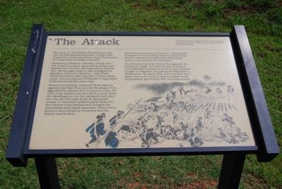
The Attack
Suddenly, a farmer, casually riding near the American lines, spurred his gorse and dashed into the fort through heavy Patriot fire. He brought word to the beleaguered garrison that Lord Rawdon, with 2000 reinforcements was only two or three days away. Greene learned of Rawdon's approach from his scouts the same day.
Greene reluctantly ordered a final assault against the Star Fort and the Stockade Fort, signaling by cannon fire at noon on June 18. fifty men rushed into the ditch to pull down the sandbags on the fort parapets and open the way for the main body of American troops. A volunteer assault party from the fort circled from behind and charged the Americans with fixed bayonets. About fifty patriots were killed of wounded and the attack was broken.
After three-quarters of an hour, "seeing little Prospect of succeeding without heavy Loss," Greene ended the attack and ordered his army to retreat toward Charlotte.
The British had held Ninety Six against the American siege, but they could not keep it. Lord Rawdon arrived in June 21 and ordered Cruger to abandon the post and withdraw to Charleston. By early July, the trenches were filled, the town burned, and stockade walls demolished, and Ninety Six was abandoned.
Erected by National Park Service.
Topics. This historical marker is listed in these topic lists: Forts and Castles • War, US Revolutionary. A significant historical month for this entry is June 1892.
Location. 34° 8.765′ N, 82° 1.132′ W. Marker is in Ninety Six, South Carolina, in Greenwood County. Marker can be reached from South Cambridge Street. Marker is located near the entrance to Star Fort. Touch for map. Marker is in this post office area: Ninety Six SC 29666, United States of America. Touch for directions.
Other nearby markers. At least 8 other markers are within walking distance of this marker. The Forlorn Hope (here, next to this marker); The Mine (within shouting distance of this marker); The Star Fort (within shouting distance of this marker); Covered Way (within shouting distance of this marker); The Rifle Tower (within shouting distance of this marker); The Well (within shouting distance of this marker); Second Approach Trench (about 300 feet away, measured in a direct line); Second Parallel (about 300 feet away). Touch for a list and map of all markers in Ninety Six.
More about this marker. This is the twelfth marker on the Ninety Six Historical Park Walking Tour.
Also see . . . Ninety Six National Historic Site. (Submitted on September 8, 2008, by Brian Scott of Anderson, South Carolina.)
Additional commentary.
1. Pvt. Thomas Purdham, 2nd Virginia
Thomas Purdham was born ca. 1751 in Culpeper County, Virginia. He enlisted for 18 months in late June 1780 in Culpeper Co., Virginia in company commanded by Captain Harrison in the regiment commanded by Colonel John Green of Culpeper "in the line of the state of Va. and second Va. Regiment." The regiment arrived in Petersburg or Richmond from there under the command of Captain Williams and served until Dec. 1781 but did not receive discharge until Jan. 18, 1782 in the town of Salisbury, N.C.
Thomas Purdham was among those severely wounded in battle of the Star Fort (Ninety-Six) in South Carolina on June 18, 1781 by a bayonet through the body. Despite his wound, he survived the war and died sometime after 1827. He resided in the central Shenandoah Valley after the Revolutionary War.
— Submitted July 5, 2009, by Robert H. Moore, II of Winchester, Virginia.
Credits. This page was last revised on November 20, 2020. It was originally submitted on September 8, 2008, by Brian Scott of Anderson, South Carolina. This page has been viewed 944 times since then and 18 times this year. Photos: 1, 2, 3. submitted on September 8, 2008, by Brian Scott of Anderson, South Carolina. • Craig Swain was the editor who published this page.


