Near Manzanita in Tillamook County, Oregon — The American West (Northwest)
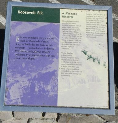
Roosevelt Elk
A Lifesaving Resource
Elk provided a reliable food source for local Native Americans, explorers, and early settlers. During their winter sojourn at Fort Clatsop (1805-1806), the Lewis and Clark Expedition relied heavily on elk. “It we find that the Elk have left us,” noted William Clark in his journal on March 5, 1806, “we have determined to assend the (Columbia) river slowly and endeaver to precure Subsistance. . . .”
Wanton slaughter and commercial hunting brought the stateís elk population to the brink of extinction by the late 1890s - only a few small herds remained in remote areas of the Coast Range. Oregonís Legislature protected elk in 1899, and it was thirty years before hunting was again allowed.
During the 1960s, and 1970s, elk transplanted by the state from the North Coast, re-populated the Cascade and Coast ranges. Today, thousands of these majestic animals thrive along this coast, providing recreation opportunities for hunters and wildlife viewers. Jewell Meadows Wildlife Area, 10 miles north of Highway 26, is an excellent place to view elk.
Erected by Oregon Department of Transportation.
Topics and series. This historical marker is listed in this topic list: Animals. In addition, it is included in the Lewis & Clark Expedition series list. A significant historical date for this entry is March 5, 1806.
Location. 45° 44.673′ N, 123° 57.64′ W. Marker is near Manzanita, Oregon, in Tillamook County. Marker is on Oregon Coast Highway (U.S. 101) near Meadow Loop, on the left when traveling north. Touch for map. Marker is in this post office area: Manzanita OR 97130, United States of America. Touch for directions.
Other nearby markers. At least 8 other markers are within walking distance of this marker. Oswald West (here, next to this marker); In Harmony with Nature (here, next to this marker); Neahkahnie Mountain (here, next to this marker); a different marker also named Oswald West (here, next to this marker); Safety and Beauty (about 700 feet away, measured in a direct line); From Footpath to Highway (about 700 feet away); The First People (about 800 feet away); Uncanny Neahkahnie (about 800 feet away). Touch for a list and map of all markers in Manzanita.
Credits. This page was last revised on February 5, 2018. It was originally submitted on February 5, 2018, by Barry Swackhamer of Brentwood, California. This page has been viewed 258 times since then and 29 times this year. Photos: 1, 2. submitted on February 5, 2018, by Barry Swackhamer of Brentwood, California.

