Reno in Washoe County, Nevada — The American Mountains (Southwest)
N.C.O. Railroad Depot
1910

Photographed by D-Mo, October 30, 2015
1. N.C.O. Railroad Depot Marker
This building was constructed as a passenger depot for the Nevada-California-Oregon Railroad, a narrow-gauge line connecting Reno with northern California and southern Oregon.
It began operations in 1882 as the Nevada and California Railroad. Reno was its headquarters with a roundhouse, repair shops, and a storage yard situated at this location. Northward expansion of the line terminated at Lakeview, Oregon, January, 1912.
In 1917, the Western Pacific Railroad purchased the N.C.O. line from Reno to Herlong, California, and standard gauged it. The depot continued to serve the traveling public until 1937.
State Historical Marker
Erected by Nevada State Park System - Troop 76 Boy Scouts of America. (Marker Number 210.)
Topics. This historical marker is listed in this topic list: Railroads & Streetcars. A significant historical month for this entry is January 1912.
Location. 39° 31.864′ N, 119° 48.579′ W. Marker is in Reno, Nevada, in Washoe County. It can be reached from E 4th St (Nevada Route 647). It is to the right of the side entrance, inside the fence. Touch for map. Marker is in this post office area: Reno NV 89512,
this page online

Regionally, this marker is in the Sierra Nevada and in the Lake Tahoe Basin. It is also in the American Mountain West. Globally, it is in North America, the Western Hemisphere, the Western World, and the Anglosphere. Historically, it finds itself in what was once New Spain and also Mexico’s Alta California.
Other nearby markers. At least 8 other markers are within walking distance of this marker: The Reno Depots (approx. 0.2 miles away); Mizpah Hotel (approx. ¼ mile away); “The Biggest Little City in the World” (approx. 0.3 miles away); "Sister Act" (approx. 0.3 miles away); Jacob Davis's Tailor Shop (approx. 0.3 miles away); Salvation Army (approx. 0.3 miles away); Votes for Women (approx. 0.4 miles away); The Reno Arch (approx. 0.4 miles away). Touch for a list and map of all markers in Reno.
Another marker is no longer nearby. Reno at the Crossroads (was approx. 0.4 miles away but has been replaced with another marker now near it).
Additional commentary.
1.
The replacement marker has been relocated to the side entrance of the brewery, as seen in Photo 2.
— Submitted December 21, 2024, by Marc Belanger of Reno, Nevada.

Photographed by D-Mo, October 2015
2. N.C.O. Railroad Depot Side Entrance and Marker

via Wikimedia Commons (Public Domain)
3. N.C.O. Railroad Depot Marker
The depot was listed in the National Register of Historic Places for its association with the Nevada-California-Oregon Railway, for the railroad development of Nevada, and for its distinctive architecture.

Photographed by Douglass Halvorsen, December 14, 2013
4. N.C.O. Railroad Depot Marker
This photo shows it at its original location at the street entrance.

Photographed by Douglass Halvorsen, December 14, 2013
5. N.C.O. Railroad Depot 4th Street Entrance
This photo shows the original location of this historical marker, to the left of the entrance.
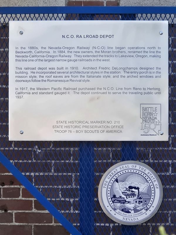
Photographed by Ysterdad, May 25, 2026
6. N.C.O. Railroad Depot Marker
Updated text
Credits. This page was last revised on July 9, 2026. It was originally submitted on February 5, 2018, by Douglass Halvorsen of Klamath Falls, Oregon. This page has been viewed 649 times since then and 61 times this year. Photos: 1, 2. submitted on July 3, 2023, by Nevada Traveler of Reno, Nevada. 3, 4, 5. submitted on February 5, 2018, by Douglass Halvorsen of Klamath Falls, Oregon. 6. submitted on June 6, 2026, by Ysterdad of Concord, California. • Andrew Ruppenstein was the editor who published this page.
