
Eastport in Annapolis in Anne Arundel County, Maryland — The American Northeast (Mid-Atlantic)
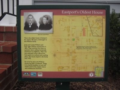
Eastport's Oldest House
Photographed by F. Robby, January 15, 2008
1. Eastport's Oldest House Marker
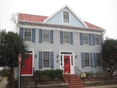
This is the oldest house in Eastport. For nearly 100 years it belonged to the Williams family.
Jonas and Louisa Williams and their eight children moved here in 1876. They used the first floor as a grocery store, selling homemade sauerkraut to neighbors. After she was widowed, Louisa offered her front parlor as a school and a polling place. The house stayed in the family until 1972.
For all of its years, the Williams House has been a landmark. Today, it is a bed and breakfast inn and still retains much of its original charm and architectural character.
[Caption:]
The Williams House is shown in green on this 1908 Sanborn Map. Note the pink rowhouses of Murphy's Row on Port Lane nearby.
Erected by Chesapeake Bay Gateways Network, Annapolis Maritime Museum, Four Rivers Garden Club. (Marker Number 7.)
Topics. This historical marker is listed in these topic lists: Education • Industry & Commerce • Notable Buildings • Settlements & Settlers. A significant historical year for this entry is 1876.
Location. This marker has been replaced by another marker nearby. It was located near 38° 58.42′ N, 76° 28.748′ W.
this page online

Regionally, this marker was in Central Maryland. It was also in the American Mid-Atlantic and in the Chesapeake Bay Region. Globally, it was in the North Atlantic Region, North America, the Western Hemisphere, the Western World, and the Anglosphere. Historically, it found itself in what was once one of the original Thirteen Colonies and also the Antebellum South.
Other nearby markers. At least 8 other markers are within walking distance of this location: A different marker also named Eastport's Oldest House (a few steps from this marker); a different marker also named Murphy's Row (within shouting distance of this marker); Heather's Hangout (about 400 feet away, measured in a direct line); The Glass Works (about 500 feet away); a different marker also
Photographed by F. Robby, January 15, 2008
2. The Williams House
Other markers no longer nearby. Murphy's Row (was within shouting distance of this marker but has been replaced with another marker now near it); a different marker also named The Glass Works (was about 500 feet away but has been replaced with another marker now near it); The Start of Something Big (was about 600 feet away but has been replaced with another marker now near it); Fort Horn (was about 700 feet away but has been permanently removed); The Fort at Horn Point (was about 700 feet away but has been replaced with another marker now near it); a different marker also named Three Great Boat Yards, One Location (was about 700 feet away but has been replaced with another marker now near it).
Credits. This page was last revised on October 26, 2025. It was originally submitted on February 23, 2008, by F. Robby of Baltimore, Maryland. This page has been viewed 2,694 times since then and 39 times this year. Last updated on March 11, 2018, by Devry Becker Jones of Washington, District of Columbia. Photos: 1, 2. submitted on February 23, 2008, by F. Robby of Baltimore, Maryland. • Bill Pfingsten was the editor who published this page.
