The Arrival of the Railroad
⎯⎯⎯
L'Arrivée du Chemin de Fer
this page online
[Photo captions, left to right, read]
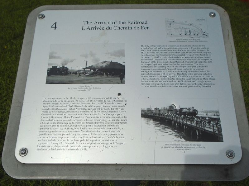
• Union Station circa early 1900's
• Train with salmon fishing on the lakefront circa early 1900's
Le développement de la ville de Newport a été grandement modifié par l'arrivée du chemin de fer au milieu du 19e siècle. En 1863, venant du sud, le Connecticut and Passumpsic Railroad, [arrivait] à Newport. Puis, en 1873, une deuxième ligne, le Missisquoi and Clyde Rivers Railroad Company (connu, aussi, sous le nom de « Southeastern ») reliait Newport avec Richford à l'ouest. En 1887, un réseau de voies ferrées, partant de la frontière sud du Vermont, longeait la rivière Connecticut et venait se connecter avec d'autres voies ferrées à Newport pour former le Boston and Maine Railroad. Le chemin de fer a contribué au soutien des deux industries principales de Newport : le bois et le tourisme. Les grandes cours à bois et les moulins à scie
[Légendes photo, de gauche à droite, lisez]
• La « Union Station » (La Gare de l'Union) circa early 1900's
• Un train servant à la pêche au saumon au bord du lac circa early 1900's
Erected by Memphremagog Historical Society. (Marker Number 4.)
Topics. This historical marker is listed in these topic lists: Entertainment • Industry & Commerce • Railroads & Streetcars. A significant historical year for this entry is 1863.
Location. 44° 56.209′ N,

Regionally, this marker is in the Northeast Kingdom. It is also in the American Northeast and in New England. Globally, it is in North America, the Great North Woods, the Western Hemisphere, the Western World, and the Anglosphere. Historically, it finds itself in what was once the Viceroyalty of New France and also the Vermont Republic.
Other nearby markers. At least 8 other markers are within walking distance of this marker: Pomerleau Park (within shouting distance of this marker); Tour Boats on the Lake / Les Bateaux de Randonnée sur le Lac (within shouting distance of this marker); Newport's Hotels and Tourism / Les Hotels de Newport et le Tourisme (about 300 feet away, measured in a direct line); The Lane Opera House / Le « Lane Opera House » (about 400 feet away); Northern Forest Canoe Trail (about 600 feet away); Early 19th Century Newport / Newport au dèbut du 19e siècle (about 600 feet away); Hebard Building Site History / Histoire du site de l'Édifice Hebard (about 700 feet away); Newport's Splendid Years / Les Belles Années de Newport (approx. 0.2 miles away). Touch for a list and map of all markers in Newport.
Also see . . . Historical Walking Tour of Newport, Vt. Brochure. (Submitted on August 30, 2018, by William Fischer, Jr. of Reynoldsburg, Ohio.)
Credits. This page was last revised on January 25, 2020. It was originally submitted on August 30, 2018, by William Fischer, Jr. of Reynoldsburg, Ohio. This page has been viewed 531 times since then and 44 times this year. Photos: 1, 2, 3. submitted on August 30, 2018, by William Fischer, Jr. of Reynoldsburg, Ohio.
