Poipu in Kauai County, Hawaii — Hawaiian Island Archipelago (Pacific Ocean)
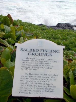
Sacred Fishing Grounds
The Hawaiians divided each island into sections—called ahupua‘a—that stretched from the mountains to the sea. The wall to your left is a reconstructed remnants of Kaua‘i’s past: it marks the boundary between the ahupua‘a of Weliweli and Pa‘a. You are now standing in Weliweli. Keoneloa Bay is in Pa‘a.
Erected by Po‘ipū Beach Foundation. (Marker Number 7.)
Topics. This historical marker is listed in these topic lists: Notable Places • Political Subdivisions.
Location. 21° 52.374′ N, 159° 26.508′ W. Marker is in Poipu, Hawaii, in Kauai County. Marker can be reached from Pe‘e Road south of Poipu Road, on the left when traveling south. It is at the end of the north parking lot of The Point at Poipu Resort, past Building 9. Turn left into the first parking lot on Pe‘e Road after the fourth speed bump. Touch for map. Marker is in this post office area: Koloa HI 96756, United States of America. Touch for directions.
Other nearby markers. At least 8 other markers are within 2 miles of this marker, measured as the crow flies. Keoneloa Bay (a few steps from this marker); Makawehi & Pā‘ā Dunes (approx. 0.3 miles away); Pu‘uwanawana Volcanic Cone (approx. ¾ mile away); Po‘ipū Beach Park (approx. 0.8 miles away); Kihāhouna Heiau (approx. one mile away); Hapa Road (approx. 1.1 miles away); Pā‘ū a Laka (Moir Gardens) (approx. 1.2 miles away); Hanaka‘ape Bay & Kōloa Landing (approx. 1.8 miles away). Touch for a list and map of all markers in Poipu.
Credits. This page was last revised on February 10, 2023. It was originally submitted on October 22, 2008, by J. J. Prats of Powell, Ohio. This page has been viewed 1,580 times since then and 26 times this year. Photos: 1, 2. submitted on October 22, 2008, by J. J. Prats of Powell, Ohio.

