East Langdon in Kent, England, United Kingdom — Northwestern Europe (the British Isles)
East Langdon
East Langdon
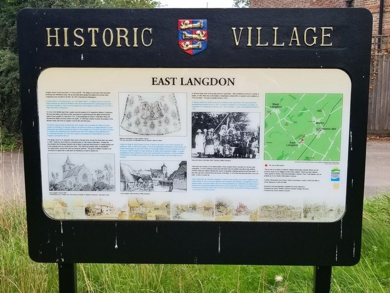
For most of the Middle Ages East Langdon was the property of St. Augustine's Abbey in Canterbury. We know the Abbey must have lost the ownership for a period because the abbot recovered the rights to East Langdon in a law suit in 1110. It lost possession for good in 1538 when Henry VIII dissolved the Abbey and took control of its lands. In 1542 East Langdon became the property of the Masters family, who lived at Langdon Court for the next 250 years.
The village church of St. Augustine dates back to Norman times, though the West tower was added in 1892. Inside the church there is a beautiful piece of 15th century embroidery. It shows the Annunciation (the Archangel Gabriel's visit to Mary) in gold and silver thread on a velvet background. It was originally worn as a cloak by the rector. The church has another rarity; an Elizabethan hour glass stand, used by the rector for timing his sermons. The grave of William Forestall in the churchyard is topped with a slab which he intended as a seat for passers-by.
In Victorian times most of the people worked in agriculture. Other inhabitants worked in a variety of trades. In 1847 there was a shoemaker, a shopkeeper, a blacksmith, a carpenter and a publican at"The Four Bells". The pub eventually closed in 1976.
There were two schools run by elderly ladies in East Langdon before education for all was made compulsory. In 1872 a National school was built which had one teacher and about sixty children. Until the 1950s the children followed the custom of parading a Mayday garland around the parish. A boy and a girl were crowned King and Queen of the May. In 1914 they had what was then a very rare treat — a ride in a motor car.
This is one of a series of Historic Village information panels which can be found in most of our villages in the Dover district. There are also Historic Town panels in Dover, Deal and Sandwich. Historic Town Trail leaflets can be picked up in our Visitor Information Centres
Further information from Dover Visitor Information Centre or Dover Museum
Research and photographs supplied by Dover Museum.
Designed by Dover District Council Creative Design Services.
Produced by Dover District Council.
( photo captions )
- East Langdon 1892 A watercolour by J L Roget, son of the famous compiler of 'Roget's Thesaurus', who lived in Deal
- Medieval embroidery in East Langdon Church This very rare piece of embroidery was the Rector’s cape (or cloak).
- East Langdon 1929. Courtesy of Mike Saunders
- King and Queen of the May 1920. Courtesy of Mike Saunders
Topics. This historical marker is listed in this topic list: Settlements & Settlers. A significant historical year for this entry is 1291.
Location. 51° 9.98′ N, 1° 20.166′ E. Marker is in East Langdon, England, in Kent. Marker is at the intersection of Church Lane and The Street, on the right when traveling north on Church Lane. Touch for map. Marker is in this post office area: East Langdon, England CT15 5FE, United Kingdom. Touch for directions.
Other nearby markers. At least 8 other markers are within 5 kilometers of this marker, measured as the crow flies. Martin Mill (approx. one kilometer away); Blériot’s 1909 Landing Site (approx. 4 kilometers away); Louis Blériot 1909 (approx. 4 kilometers away); Dover’s defences (approx. 4.2 kilometers away); Arthur’s Hall (approx. 4.2 kilometers away); Buildings of Dover Castle (approx. 4.2 kilometers away); Medieval Dover (approx. 4.3 kilometers away); Dover’s early history (approx. 4.3 kilometers away).
Also see . . . East Langdon on Wikipedia. (Submitted on January 15, 2019, by Michael Herrick of Southbury, Connecticut.)
Credits. This page was last revised on January 27, 2022. It was originally submitted on January 15, 2019, by Michael Herrick of Southbury, Connecticut. This page has been viewed 141 times since then and 16 times this year. Photos: 1, 2. submitted on January 15, 2019, by Michael Herrick of Southbury, Connecticut.

