Near Ammon in Bonneville County, Idaho — The American West (Mountains)
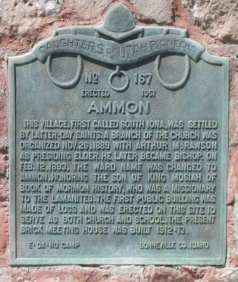
Ammon
Erected 1951 by Daughters of Utah Pioneers, Camp, Bonneville Co. Idaho. (Marker Number 167.)
Topics and series. This historical marker is listed in these topic lists: Churches & Religion • Settlements & Settlers. In addition, it is included in the Daughters of Utah Pioneers series list.
Location. 43° 28.214′ N, 111° 58.04′ W. Marker is near Ammon, Idaho, in Bonneville County. Marker is at the intersection of Central Avenue and Molen Street, on the right when traveling south on Central Avenue. Touch for map. Marker is at or near this postal address: 3000 Central Avenue, Idaho Falls ID 83406, United States of America. Touch for directions.
Other nearby markers. At least 8 other markers are within 5 miles of this marker, measured as the crow flies. Farmers' and Merchants' Bank (approx. 4 miles away); The Odd Fellows (approx. 4 miles away); Taylor's Bridge (approx. 4.1 miles away); Eagle Rock Ferry (approx. 4.1 miles away); Upper Snake River Valley Irrigation (approx. 4.2 miles away); Eagle Rock Meeting House (approx. 4.2 miles away); Eagle Rock Crossing (approx. 4.2 miles away); The Idaho Falls LDS Hospital and School of Nursing (approx. 4.2 miles away).
More about this marker. This marker is on L.D.S Church grounds.
Credits. This page was last revised on October 3, 2019. It was originally submitted on October 3, 2019, by Barry Swackhamer of Brentwood, California. This page has been viewed 351 times since then and 35 times this year. Photos: 1, 2. submitted on October 3, 2019, by Barry Swackhamer of Brentwood, California.

